Walk
Loop
7.75miles
(12.47km)
4 hours

Walking

Legbourne Walk Two

Legbourne

A lovely circular walk through the gently rolling wooded landscape close to Legbourne on the edge of the Lincolnshire Wolds.

Starting point
Village pump at the junction of Church Lane and Station Road
Louth
LN11 8LL
Grid reference: TF 367 843

  • ParkingParking
  • RefreshmentsRefreshments
  • Dog FriendlyDog Friendly

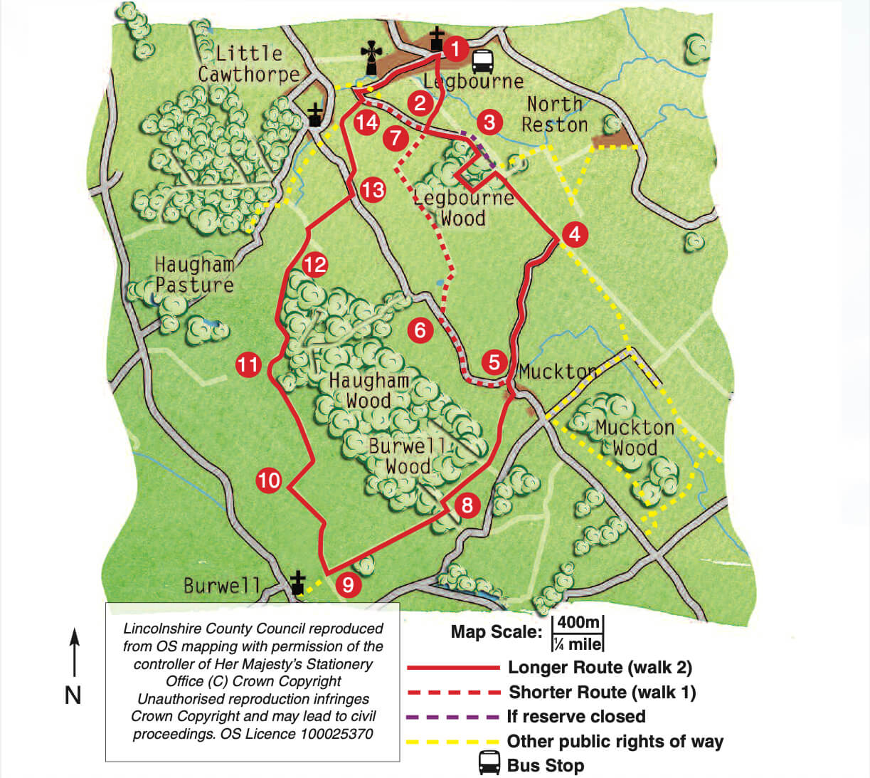
Legbourne lies on the eastern edge of the Lincolnshire Wolds in an area known as the Middle Marsh. These lovely walks make the most of the gently rolling wooded landscape of the area. On a clear day you will be rewarded with views of the coast.

The Lincolnshire Wolds is an Area of Outstanding Natural Beauty (AONB). Rolling chalk hills and areas of sandstone and clay underlie the attractive wolds landscape. Inhabited since prehistoric times the appearance of the countryside today has been influenced by past and present agricultural practices. A priory was founded in Legbourne around 1150 by Robert FitzGilbert for Cistercian nuns and dissolved by Henry VIII in the 16th century. All that remains of the priory now are earthworks. All Saints' church, in the middle of the village, was built in the late 14th century and restored in the mid 19th century.

The decorative village water pump was built in 1877 by Canon Overton, in memory of his mother, to provide water for his parishoners and for “wayfarers”. It was the village’s water supply until mains water arrived in 1953.

Legbourne Wood is one of the few remaining ancient woodlands in eastern Lincolnshire and is owned and managed by the Lincolnshire Wildlife Trust. Ancient woods like this which have had continuous woodland cover since 1600 are rich in wildlife. Oak and ash trees dominate the canopy and there are over 60 different species of wildflower including primrose, bluebell, sweet woodruff, wood sorrel and wood anemone.

Haugham and Burwell woods, is classified as ancient woodland and is privately owned. Two Bronze Age round barrows are located within the wood. Now covered and hidden by trees they would have originally been prominent in the landscape at 20m (65 ft) in diameter and 2m (6 ft) high with gently sloping sides.

As you walk through the woods and along the edges look out for muntjac deer. These small deer, approximately 19 in (48cm) were introduced into Britain around 1900 when the Duke of Bedford brought them from Asia to his Woburn estate in Bedfordshire. Escapees from the estate have bred and spread across the country, preferring woodland or scrub areas.

  • 1From the village pump, cross the main road with care and follow the public footpath opposite diagonally across the field. At the road turn left and after 50m turn right between two houses to a bridge. Cross the bridge, turn left and follow the footpath beside a ditch to another bridge. Cross the bridge and follow the footpath to a track.
  • 2Turn right to a road. Turn left and follow the road as it becomes a track and bridleway.
  • 3On the right is the entrance to Legbourne Wood nature reserve. Enter the reserve and follow the track straight ahead, the line of the old railway. Access to the wood is by kind permission of Lincolnshire Wildlife Trust, please keep to the waymarked route and keep dogs on leads. After approximately 300m turn right into the woodland and follow the waymarked walk through the wood to return to the track. Leave the reserve through the gate on the right and turn right along the bridleway. If Legbourne Wood reserve is closed, instead of entering the reserve, continue ahead along the bridleway and past the second entrance to the reserve.
  • 4After approximately 700m at a junction of bridleways, turn right. At the lane turn left.
  • 5At the T junction turn left and follow the road. At the top of the slope, as the road bends left, turn right onto the public footpath. Walk in front of the cottage and then straight on into and across the field. Follow the footpath straight across the next field to the corner of a wood. Continue ahead beside the wood and then cross a track and continue straight on.
  • 6(Shorter route see Legbourne - walk one)
  • 7(Shorter route see Legbourne - walk one)
  • 8At the corner turn left and then right into the woodland. Leave the wood and follow the footpath across the field, on a grass track, and then alongside a small wood to a junction of footpaths. (To visit Burwell turn left).
  • 9Turn right and follow the track.
  • 10At a junction of tracks turn right along the footpath. After approximately 0.25 miles (450m) turn left to follow the sign across the field. Cross the ditch and carry straight on across the next field to the corner of the wood. Continue on in the same direction along the wood edge.
  • 11At the junction with a track bear right across the field corner to the wood. Follow the path up the side of the wood and then around the wood to a waymarker.
  • 12Turn left to walk along a track across the field to a tree and hedge. Turn left and after approximately 120m turn right over a bridge.
  • 13At the road turn left. After approximately 70m turn right and then after 20m turn left over a bridge. Follow the footpath across the field to a gap in the hedge ahead and then straight on to a stile in the next hedge. Bear slightly right across the next field to a stile in the hedge, to the right of the telegraph pole. Walk straight ahead along the field edge to the corner. Turn right, over a stile and footbridge, and then after 15m turn left.
  • 14Bear right across the field to a gate in the hedge and walk straight on beside the hedge of the next field. Go through kissing gates and along a track to a road. Turn left. Follow the road, as it bends right by the ford, to return to the centre of Legbourne and the starting point.

This walk uses quiet roads, field paths and woodland paths.

You may encounter stiles and livestock.

more information

Starting point

Village pump at the junction of Church Lane and Station Road

Louth

LN11 8LL

Grid reference: TF 367 843