Things to look out for
Tick off the landmarks and points of interest you spot along this route as you go.
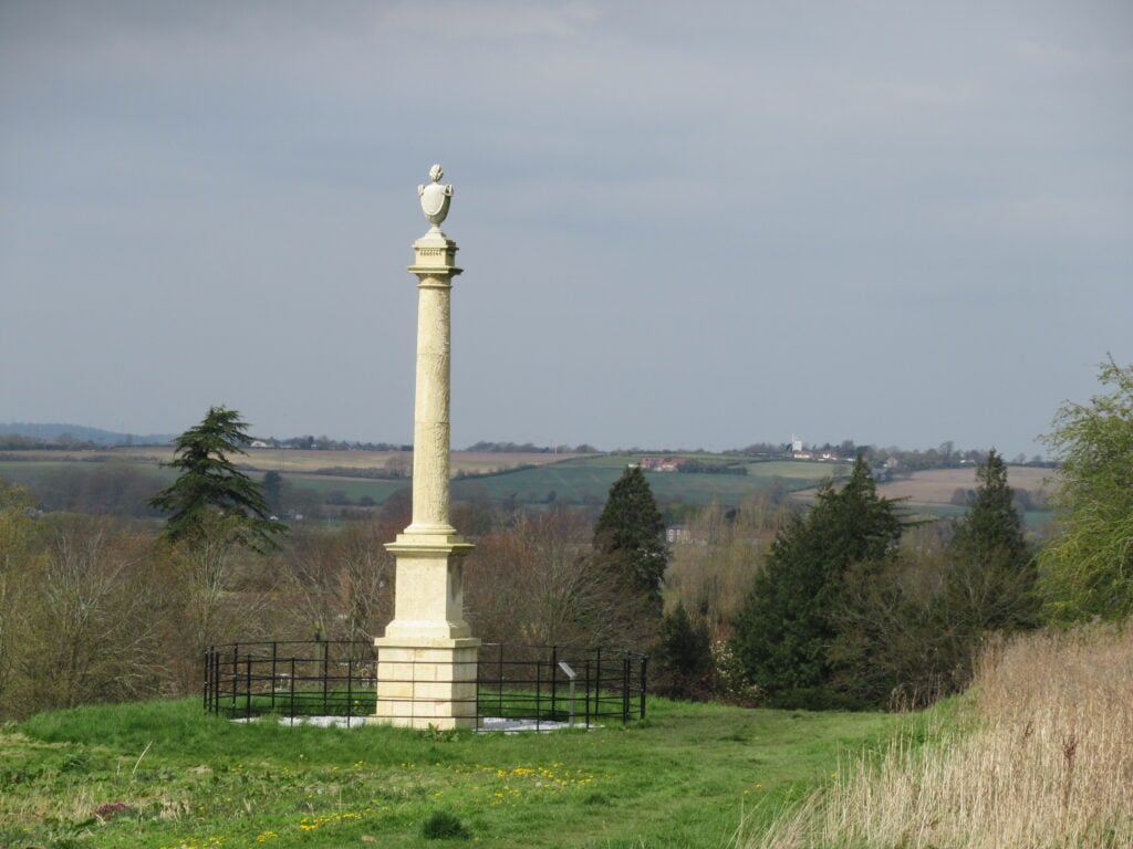
Bigby monument
Erected in 1790 by Edward and Ann Weston of Somerby Hall to commemorate 29 years together.


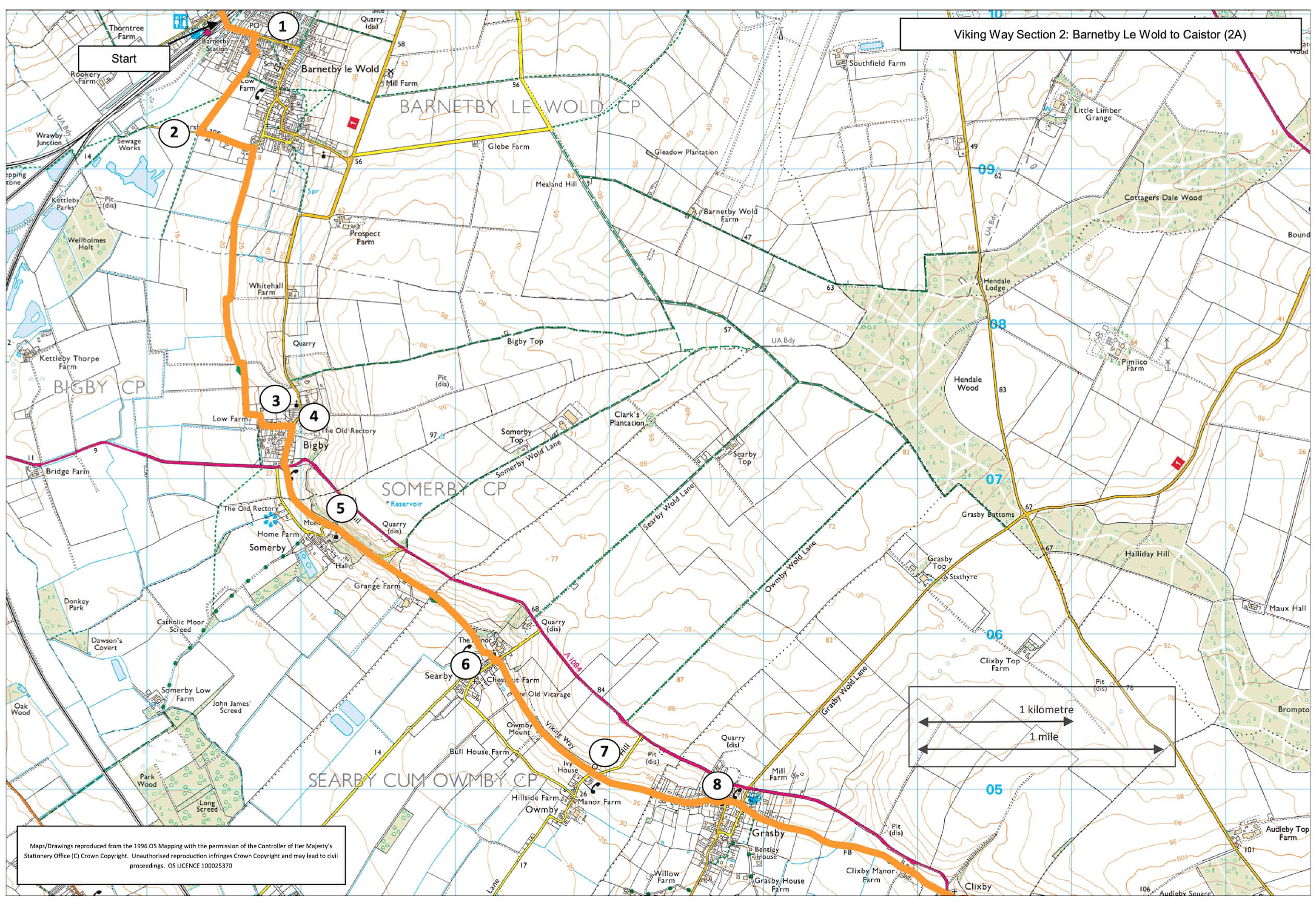
- 1Walk under the railway bridge and take the third turning on the right, St Marys Avenue. At the car parking area at the end of the road turn right onto a bridleway. At the barn and where the track bends left, bear slightly right to continue in the same direction between a hedge and fence.
- 2At the road turn left. As it bends to the left turn right onto a footpath. Where the stone track bends left leave the track and continue straight ahead. At the field corner turn left and then right over a bridge by a telegraph pole. Walk straight ahead under the line of poles. At the field edge turn right and then almost immediately left. At the end of the field and at a track turn left and after approx. 30m turn right beside a hedgerow. At the field corner cross two bridges and turn left along the filed edge. Follow the path left around a paddock to a track.
- 3Turn right and then follow the road to the left and to T- junction.
- 4Turn right along Main Street to another T- junction. Cross this busy road with care and continue along the footpath ahead across meadows to a road.
- 5At the road bear left uphill and follow the road for approx. 350m, bear right onto the lane for Grange Farm. Follow the path past the farm and ahead to a road in Searby village.
- 6Turn left and follow the road through the village to a T-junction. Turn left and then right onto a public footpath and follow it to a road.
- 7Cross the road and continue along the footpath to the edge of Grasby village. Continue ahead along the road and past the church.
- 8At the junction with Church Hill keep straight on. At the next junction bear right onto Clixby Lane and head out of Grasby. At the end of the lane follow the footpath ahead along the field edge, across a field, alongside a wood and then across another field to a farm. Walk past the farm buildings and keep straight ahead along the driveway to a road.
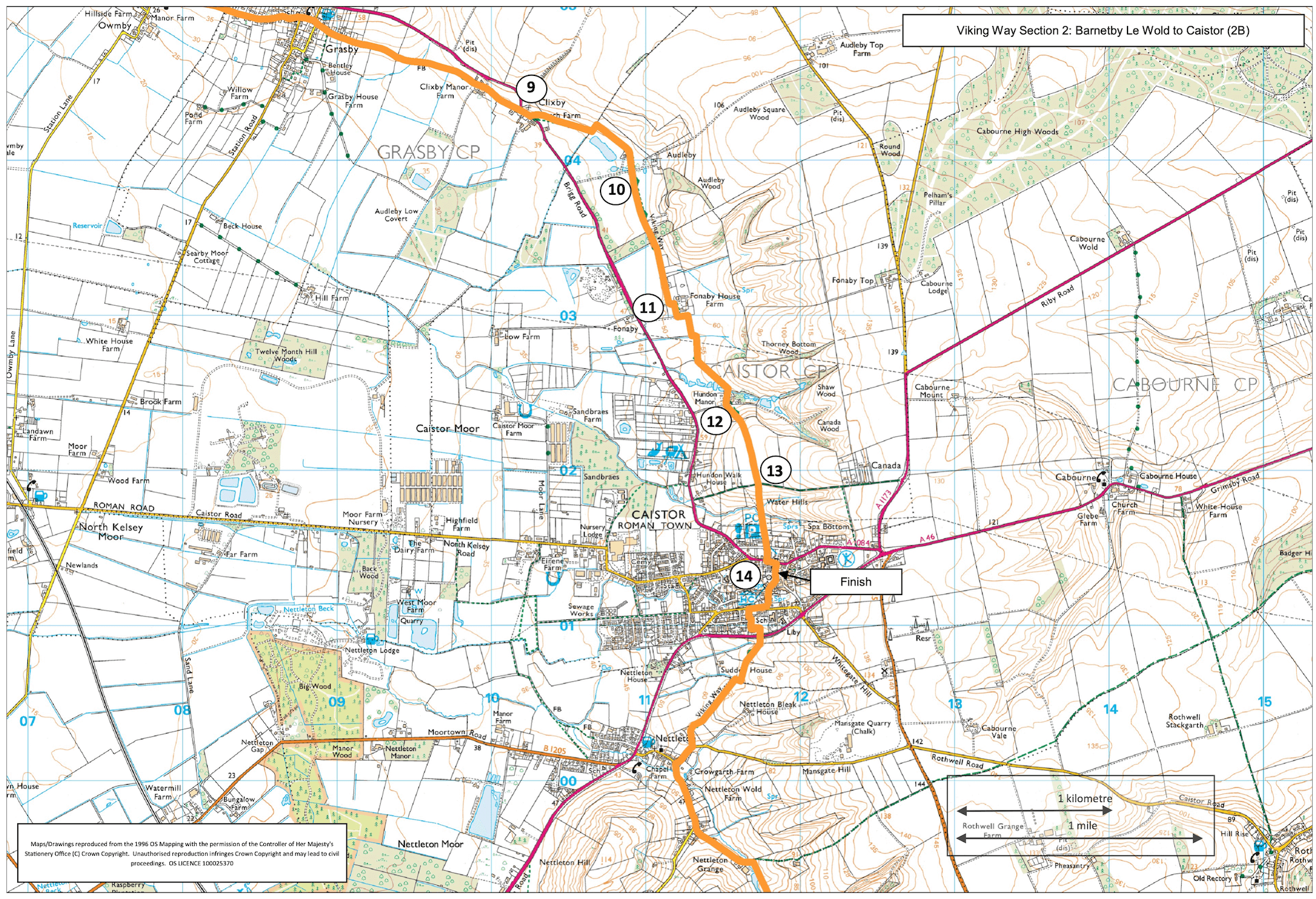
- 9Turn right and walk along the verge for approx. 60m. Take on this busy road, cross the road and follow the footpath opposite by bearing right across the field to the corner. Walk straight across the next field to a hedge, go through the gap and turn left and then after approx. 40m turn right and follow the path straight on to the left corner of the small wood/hedge ahead. Continue ahead between the hedge and fence and then continue along the fence line to walk past a pond to a lane.
- 10Cross the lane and continue straight on along the track and then path into the wood ahead. Walk through the wood and then straight on along the field edge, past a house to a lane.
- 11Turn left and just before the house gates turn right and walk between the fences to the edge of an arable field. Turn left and walk along the field edge to the corner. Go into the next field and turn right and walk along the field edge. At the corner leave the field, bear left to a gate/stile. Enter the field, turn right and follow the field edge to a bridge. Cross the bridge and bear left across the field to fingerpost and bridge. Follow the path over the bridge and then straight on across the paddocks to a lane.
- 12Cross the lane and bear left uphill and continue ahead across the fields to a junction with a bridleway.
- 13Continue straight ahead along the footpath, between hedges and then past cottages to a road. Cross the road and continue along a walled alley to another road.
- 14Turn left and then right to reach Caistor Market Place.