Walk
Loop
3.5miles
(5.63km)
1 hour
45 mins

Walking

Denton & Harlaxton Short Walk

Denton and Harlaxton

This walk is set in and around two rural villages that lie at the edge of the Trent and Belvoir Vales, where the land rises to join the Kesteven Uplands, to the south-east and Leicestershire Wolds, to the south-west. Here is a more mixed farming character than is often associated with Lincolnshire.
Here you may hear or see a buzzard.

Underlying this area are Lower to Middle Jurassic rocks, laid down around 180 million years ago. These rocks contain iron ore, and by the middle twentieth century parts of this landscape had been transformed by opencast extraction of the ore and construction of railways to carry it to blast furnaces in Northamptonshire.

Denton is an attractive stone village set in parkland. Its name being Saxon for farmstead in the valley.

Many houses were built during the 19th and 20th century from the local golden ironstone. Much of the land surrounding the village is owned by the Welby family who moved into the area during Tudor times and once lived in Denton Manor until it was taken down in 1939. The gate house can still be seen at the crossroads on the Grantham Road.

St Andrew’s church was founded around 1200 with later 14th and 16th century alterations and additions and inside stands a 1714 life sized marble figure of Richard Welby.

Many of the cottages in the pretty village of Harlaxton were rebuilt by the Gregory family between 1790 and 1854 in the cottage orné style.

The building of the current Harlaxton manor was started in 1832 by Anthony Salvin and was continued by William Burn. The old manor house was demolished around 1840.

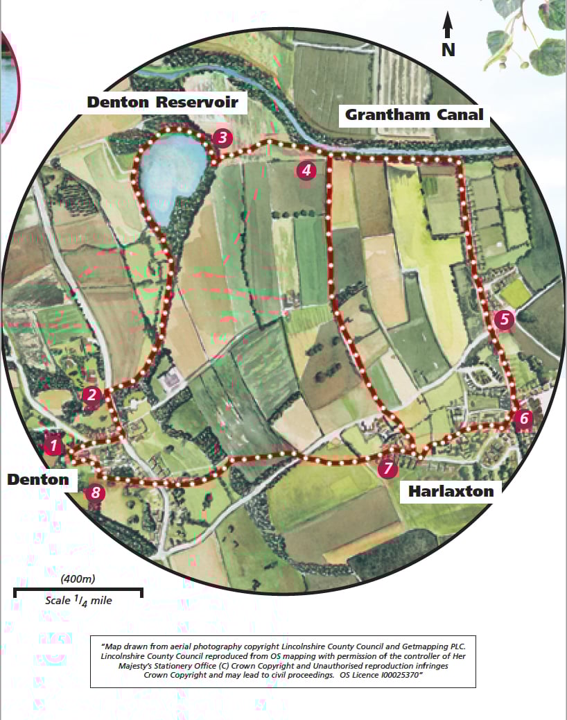
Starting point: At St Andrew’s Church, Denton
Grid reference: SK 865 325.

  • Linked to Public TransportLinked to Public Transport
  • RefreshmentsRefreshments
  • Dog FriendlyDog Friendly

As you leave the village the last row of cottages on the right are former almhouses built in 1869. In the central gable a recessed panel contains a shield bearing the Welby Arms.

The reservoir was built to supply the Grantham Canal and can hold 277 million litres (61 million gallons) of water. It is home to a variety of birds including coot, moorhen, mallard, heron and great crested grebe. Grebes usually lay 4 eggs which take about 4 weeks to hatch into distinctively striped chicks which are often carried on the back of the parents.

The canal was built in 1793 and runs 33 miles (53 km) from the River Trent in Nottingham to the Grantham basin, with a fall of only 150 feet (43 metres). Coal, coke, lime, building materials were transported from Nottingham to Grantham and agricultural produce was taken in the opposite direction. The canal was a success until the Nottingham to Grantham railway opened in 1851. The canal was closed in 1929 and is now maintained by the British Waterways Board. Sections of the towpath now form part of the National Cycle Route.

As you walk across the field, between point 7 and 8, look out for Belvoir Castle on the horizon ahead of you. Ancestral home to the Duke and Duchess of Rutland a castle has stood on the site since Norman times. The medieval castle was largely rebuilt in the 19th century.

Horse Chestnut trees were introduced to Britain in the late 16th century from the Balkans and were often grown in ornamental avenues for their decorative white candle like flowers which appear in May.

The impressive house opposite the church is Leys House which was built as a school in 1720 and restored in 1855.

  • 1From the church follow the road around to the right and past the Welby Arms and school. Go straight over the first junction and at the second turn left onto Casthorpe Road.
  • 2Approximately 100m after the cottages, cross the stream and turn right onto the public footpath and follow it along a track and across the field to the far right hand corner up a bank. Cross a track (the old mineral railway line) and carry on beside the the feeder stream to the reservoir. Walk 3/4 of the way around the reservoir (approximately 800m or 1/2 mile).
  • 3Turn left onto a public footpath which goes down some steps and across a bridge. Carry on in the same direction between two hedges and then along a field edge/track. At the field corner go over the bridge ahead and follow the footpath across/around the field to the far corner. Go through the gap in the hedge. The Grantham Canal is now on your left.
  • 4Turn right. Go through a field gate to join a track which will lead you uphill to the road. Cross the road (take care crossing this busy road) and walk down Rectory Lane to the corner and turn right onto West End. Rejoin the walk directions at point 7.
  • 7Cross the road and walk along West End and continue straight on through a gate and bear diagonally right across the field aiming to the right of the line of trees in the hedge, to the main road. Cross the road with care and take the footpath diagonally left across the field aiming for Denton Church tower, just visible above the trees in the distance. Cross the old railway line again and continue in the same direction over a footbridge, then walk to the far right hand corner of the field. Follow this path back to Denton Main Street.
  • 8Cross the road and follow the public footpath between two cottages almost immediately opposite. Cross the bridge and continue straight on under the horse chestnut trees to a gate. Turn right down the road and follow the public footpath on the left behind the school, to return to the church.

This walk uses roadside pavements, field paths and tracks. There are stiles and you may encounter livestock.

more information

Starting point: St Andrew’s Church, Denton, NG32 1LG

Grid reference: SK 865 325.