


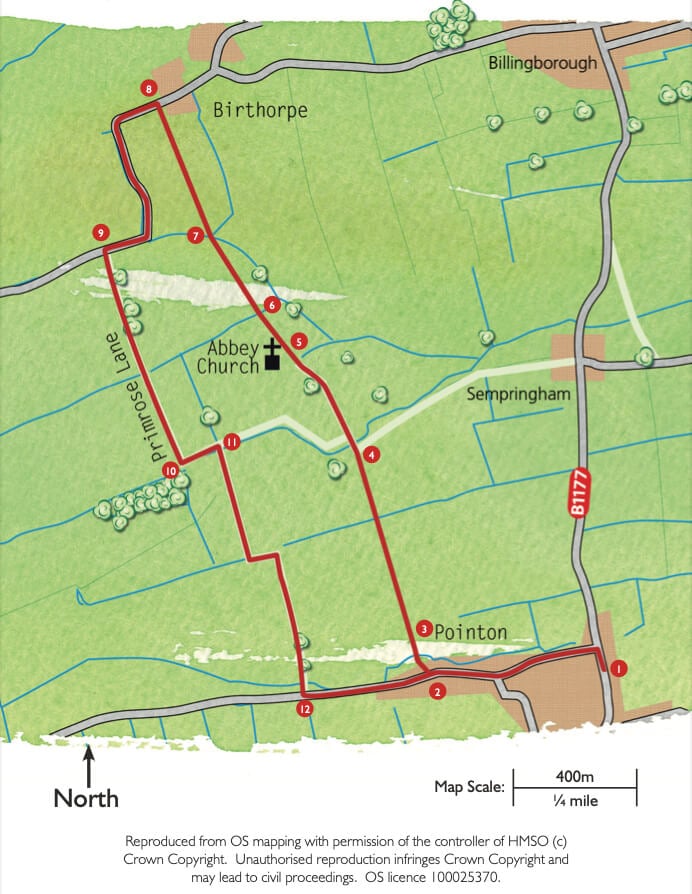
- 1Walk along West Road past the Primary School on the right and look out for a kissing gate on the right just past the post box.
- 2Walk through the kissing gate and cross the field diagonally to a second gate.
- 3Go through the gate and over a small bridge. The footpath now continues straight ahead, northwards, between arable fields rising gently and giving views all around. As you go over the crest of the hill you will see the pinnacles of Sempringham Abbey (the church of St Andrew) coming into view centre left ahead. To the right you can see Billingborough church spire and on a clear day, Boston Stump nearly 20 miles away. Cross a small footbridge continuing in a straight line.
- 4The path eventually leads to a bridge over the Marse Dyke and a rough road. Continue in the same direction along this road towards the Abbey church.
- 5At the church gates take the footpath, straight ahead, following the churchyard wall on your left. Ignore the path that turns right and carry straight on.
- 6Cross the wooden footbridge and follow the footpath across the field towards the left of a small group of trees ahead.
- 7At the left end of the trees cross the bridge. Continue straight up the hill across the arable field. You will soon see the barns at Birthorpe come into view. Pass the barns tightly on their left-hand side to a road.
- 8Turn left along the road and follow it as it bends left.
- 9The road then bends to the right and after 150 metres reaches a track on the left signposted as a restricted byway. Follow this historic byway, known as Primrose Lane, with trees on your left and a hedge on your right. After 300 metres you keep straight on along a narrower enclosed stretch of track with trees on both sides. After another 400 metres the trees finish on the right and you come to a T-junction in the path.
- 10At the T- junction in the path turn left towards the Abbey.
- 11After 200 metres turn right over a large wooden bridge over the Marse Dyke and walk up the hill. Near the top of the hill the track bends to the left and then to the right. Keep on the track and reaching the brow of the hill you will get a view of the old vicarage at Pointon ahead, followed by much of Pointon Village to the left.
- 12Where the track finishes at the road turn left. You are now back on West Road, Pointon and by walking 1 km (2/3 miles) along the road you will come back to your starting point at Pointon High Street.