Walking

Wragby & Goltho Walk Long

Wragby,Goltho

A lovely walk through the Lincolnshire Limewoods area taking in new and established woodland, the site of a deserted medieval village and an isolated chapel.

Starting point
Market Place
Wragby
LN8 5QU
Grid reference: TF 132 780

  • ParkingParking
  • Linked to Public TransportLinked to Public Transport
  • RefreshmentsRefreshments
  • Dog FriendlyDog Friendly

The Lincolnshire Limewoods area, between Wragby, Bardney and Woodhall Spa, is a great place to explore with ancient woodlands, medieval abbey ruins, and a wealth of wildlife and history.

The Lincolnshire Limewoods are the most important examples of small-leaved lime woodland remaining in Britain and have been designated as a National Nature Reserve (NNR). These woodlands date back to prehistoric times and are believed to be one of the few remaining examples of wildwood with continuous woodland cover for the last 8000 years. They provide a range of habitats for a variety of wildlife.

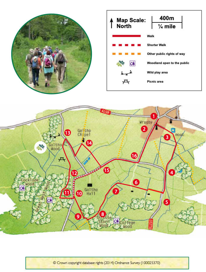
Owned and managed by Forestry England, Cocklode and Great West Woods are part of the Bardney Limewoods NNR and are examples of the best small-leaved lime woodland in Britain. Made up of mixed broadleaved trees look out for oak, silver birth, yew, small-leaved lime and hazel.

You will walk through Goltho Wood, a major habitat creation scheme by the Woodland Trust. New native woodlands, meadows, ponds and wetlands have been created, helping to extend adjacent woodlands and provide additional habitats for wildlife. Paths, picnic benches and a wild play area have also been provided.

St. George’s chapel is the only surviving building on the site of the deserted medieval village known as Goltho, meaning ‘the enclosure where marigolds grow’. Evidence suggests that the area was first occupied during the Roman period and then again in the Anglo-Saxon period and by the 12th century there was a thriving village. By the beginning of the 15th century much of the village was abandoned after harsh winters resulted in poor harvests.  An earlier stone church stood on the site of St. George’s and remains of tombstones set in the chapel floor indicate that there was a chapel on the site by the 13th century. St. George’s probably dates from the 16th century, with an 18th century chancel and Victorian bellcote. It is looked after by the Churches Conservation Trust. Sadly, in 2013 a fire destroyed the interior and roof of the chapel.

  • 1Leave the Market Place along Bardney Road, towards the old windmill.
  • 2Turn left along Mill View Road. At the end of the road continue straight on along a public footpath to the edge of the old cemetery.
  • 3Turn right and follow the footpath across the field to a hedge. Cross the bridge and continue along the footpath, ignoring a footpath on the left, to walk beside a hedge and drain to a road.
  • 4Turn left. Take care around the bends on this stretch of road (the verge on the right hand side of the road is wider).
  • 5After 400m turn right along a public footpath and follow the edge of the field straight ahead. At the end of the hedge turn left beside some trees and after approx. 80m turn right across the field to the corner of the woodland. Continue straight ahead alongside the woodland to a drive.
  • 6Walk across the drive and bear slightly left heading towards the hedge to the left of the telegraph pole ahead. Go through the gap in the hedge and bear left, cutting across the corner of the field, to the hedge. Follow the hedge and drain on the left. Where the drain bends left at a telegraph pole continue straight on across the field to a bridge over a drain.
  • 7Cross the bridge, turn left and walk beside the drain for approx. 150m. Where the drain bends to the left, walk ahead across the field bearing left to a fingerpost sited on the edge of an area of tree planting. Bear left to a bridge. Cross the bridge and bear right towards the woodland edge andbear right towards the woodland edge and fingerpost, walking through another area of planted trees.
  • 8At the finger post turn right. At the bridge and junction of footpaths turn right over a second bridge and follow the field edge straight on to a bridge into the woodland. Follow the path through the woodland.
  • 9At the woodland edge bear right through an area of tree planting and across the field heading to the right hand edge of the wooded area on the opposite side of the field. Walk through the trees to the road.
  • 10Turn left and then right into Cocklode and Great West Wood. This is a working woodland so please follow any signs or requests. Follow the main track into the woodland for 250m until you reach a path on your right – turn right.
  • 11Follow the path through the wood and then some young trees onto the Woodland Trust site, then continue straight on (middle path) through the area of planted trees to a kissing gate, with bridge beyond, that will come into view.
  • 12Walk through the gate and over the bridge, straight ahead to another gate. Go through the gate and follow the path up the slope. At the fence line and hedge turn left and follow it past the sculpture. Follow the path straight ahead, between two field gates until a bridge on your left. Cross the bridge and turn right to follow the hedgerow to a kissing gate and road.
  • 13Turn right and walk along the road for approximately 400m. Turn left along a public footpath heading towards the chapel amongst the trees in the field. Enter the church yard.
  • 14Follow the footpath out of the churchyard through the hedge on the right. Walk straight across the field to a bridge in the corner. Cross the bridge and follow the track straight onto a road and turn left.
  • 15Follow the road to a junction.
  • 16Turn left to return to the Market Place in Wragby.

The walk uses roadside paths, field paths, roads and forest tracks. There are no stiles. You may encounter livestock.

more information

Starting point

Market Place

Wragby

LN8 5QU

Grid reference: TF 132 780