Walk
Loop
5.5miles
(8.85km)
2 hours
45 mins

Walking

Stainfield & Apley Hardy Gang Walk Long

Stainfield,Apley

This walk goes through the small villages of Stainfield and Apley as well as through areas of new tree planting and the mature woodland of Hardy Gang Wood, one of the nationally important Bardney Limewoods. The walk uses quiet roads, field paths and woodland paths. It may be muddy in places if wet, especially through the woodland. You may encounter stiles on this walk.

Starting point
Stainfield and Apley Village Hall
Stainfield
Market Rasen
LN8 5JJ
Grid reference: TF 108 732

  • ParkingParking
  • RefreshmentsRefreshments
  • Dog FriendlyDog Friendly

The Lincolnshire Limewoods is an area between Wragby, Bardney and Woodhall Spa. It is a fantastic place to explore with ancient woodland, medieval religious ruins and a wealth of wildlife.

The Lincolnshire Limewoods are the most important examples of small-leaved lime woodland remaining in Britain and several have been collectively designated as the Bardney Limewoods National Nature Reserve. The woods provide a range of habitats for a variety of wildlife.

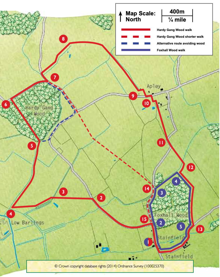
The brick church of St Andrew in Stainfield was built in 1711 on a north-south orientation. The lumps and bumps in the fields either side of the road are remnants of Stainfield deserted medieval village, the last remains of the village being cleared by Sir Philip Tyrwhitt to create formal gardens in the early 17th century.

Part of the church nave and tower is all that remains above ground of the medieval Barlings Abbey. Earthworks around the wall indicate other buildings of the monastery. The abbey was founded in 1154 by the Premonstratensians (named after Prémontré in France where the first house was founded). The abbey was closed in 1537 after the abbot and four canons were implicated in a rebellion against the closure of monastries by Henry VIII, and hanged.

Hardy Gang Wood is part of the Bardney Limewoods National Nature Reserve and is a Site of Special Scientific Interest (SSSI). Look out for small-leaved lime, ash, hazel and pedunculate oak as well as a variety of wild flowers in the spring including the common spotted orchid.

  • 1Leave the car park and turn left along the road.
  • 2Follow the road as it bends to the left (signed Langworth). After approximately 900m turn left off the road and onto a bridleway. Walk across the fields by bearing right towards the right hand corner of the copse. At the fingerpost, cross the bridge and go through the gate.
  • 3Turn left and follow the field edge for approximately 150m to a fingerpost. Bear right across the field towards a wooden fingerpost to the right of an area of scrub. The remains of Barlings Abbey can be seen ahead.
  • 4At the fingerpost, if you want to visit Barlings Abbey turn left and follow the bridleway over the bridge. To continue the walk turn right (along the Viking Way). Walk straight ahead, alongside the hedgerow and ditch until you reach a gate and bridge at the edge of the woodland on your left (approximately 900 metres).
  • 5 Enter the woodland and follow the bridleway straight ahead through the wood. The route through the wood can get very wet and muddy. If you want to avoid the wood, bear right across the field to a gate and fingerpost at the road. Turn left and follow the road for approximately 500m to a junction. Turn left and at the next junction bear right and rejoin the directions at point 7.
  • 6 At the road turn right and walk 500m to a road junction.
  • 7Turn left (signed Bullington) and after 70m turn right onto a footpath. Follow the path along the edge of an area of planted trees.
  • 8At the edge of the arable field bear right to a bridge and fingerpost that will come into view. Cross the bridge and walk straight ahead along the right hand side of the ditch. At the end of the ditch walk straight across the field ahead and then along the hedge and fence line.
  • 9 At the end of the field turn left and after 50m, and before the gate, turn right along a footpath behind some buildings and then around the edge of a garden to a road.
  • 10 At the road turn left and after approximately 80m turn right onto a footpath. Follow the track for approximately 90m before turning right into a field and following the field edge straight ahead. At the end of the barn turn left over a stile and immediately turn right and walk along the field edge to a road.
  • 11 At the road turn right and after approximately 100m turn left onto a footpath across the field, through some trees and across a bridge.
  • 12Turn right and walk alongside the drain. After 150m turn left onto a footpath beside a woodland, Foxhall Wood.
  • 13 At the road turn right, walk past the church, and at the T-junction turn right to return to the starting point.

The walk uses quiet roads, woodland paths, field paths and tracks. You may encounter stiles and livestock.

more information

Starting point

Stainfield and Apley Village Hall

Stainfield

Market Rasen

LN8 5JJ

Grid reference: TF 108 732

more about the trail

Viking Way

The Viking Way is a long distance - 147 mile way-marked trail spanning from the River Humber through Lincoln to Oakham in Rutland. The route is signposted with an icon of a Viking helmet on a yellow disk.