Walk
Loop
3.75miles
(6.04km)
2 hours

Walking

Long Sutton Walk One

Long Sutton

Long Sutton is a small market town in South Holland with many fine buildings from the 18th century. In 1307 Long Sutton was on the sea bank and Walpole Cross Keys was five miles away on the sea bank in Norfolk, separated by marshland. In 1640 three miles of the marsh was enclosed by Cornelieus Vermuyden and Long Sutton was no longer on the sea bank. In 1831 Cross Keys Embankment together with a bridge designed by John Rennie over the newly dug Nene Outfall Cut made it possible for a direct route from Norfolk into Lincolnshire. Two coaching inns in Long Sutton, the Bull Hotel and the Crown and Woolpack were well placed for passing travellers.The name Long Sutton comes from the Old English, Sutton meaning village to the south and Long being a description of a long straggling village. This walk will explore the town and surrounding open countryside.

Walk location: Long Sutton lies 8 km (5 miles) east of Holbeach.
Starting point: Market House, Market Street, Long Sutton.

  • ParkingParking
  • Linked to Public TransportLinked to Public Transport
  • RefreshmentsRefreshments
  • Dog FriendlyDog Friendly

The Market House or Corn Exchange was built in 1856 with money raised by the sale of shares. The building had space for a corn exchange, a market house, a public room for meetings and retiring rooms.

The building became the centre of town life. As well as markets and produce shows, musical evenings were regularly held. The need for the corn exchange started to decline during the 1920s when farmers started going to corn exchanges in Spalding and Wisbech. The Market House passed into private ownership and became a garage. The garage moved to a new location in the 1960s and by the end of the 20th century the building had fallen into disrepair.

In 1999 a group of local people began the long process of restoring the building to its present glory. It is now used as an information and community centre

St Mary’s church dates from the late 12th century and many Norman features are still present. The magnificent leaded spire stands 162 feet tall and is the tallest of its type in the country. It was built to the same design as the spire in Chesterfield

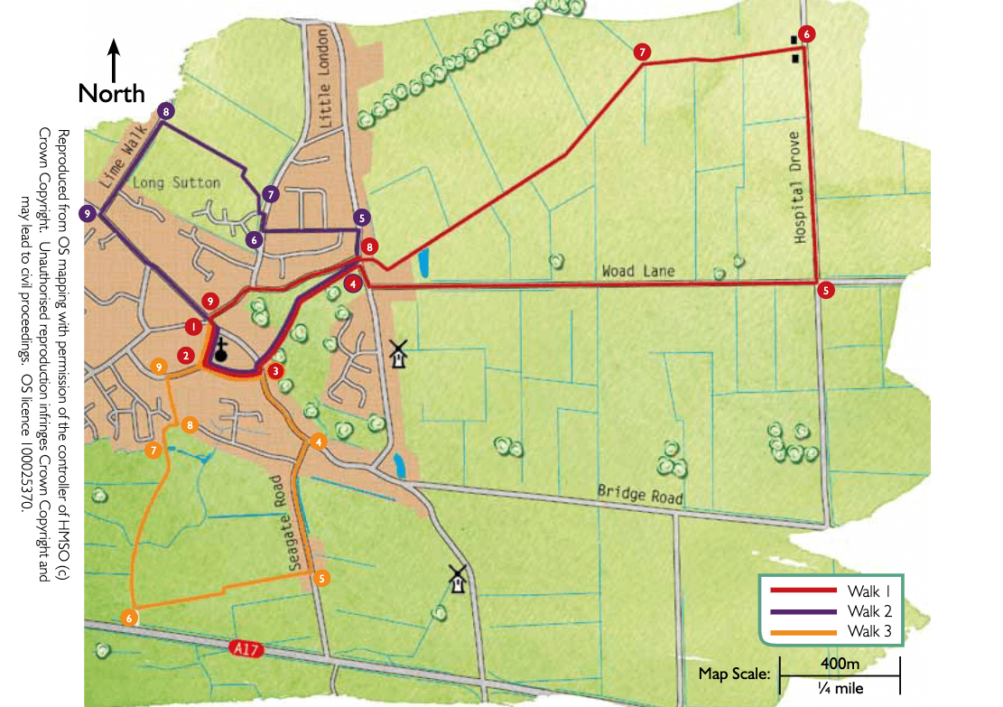
Hospital Drove marks the boundary between Long Sutton Common and the former estate of the Governors of Guys Hospital. The hospital owned the land between 1746 and 1919 when it was purchased by the Ministry of Agriculture and the large farms were turned into smallholdings

  • 1Leave the Market House and turn right. Take the second turn on the right, Market Place.
  • 2At the War Memorial and church turn left and follow the public footpath between the car park and churchyard. Continue along the edge of the churchyard to a road.
  • 3Turn left and after approximately 40m cross the road with care and walk straight ahead along the public footpath between two houses and into the park. Follow the surfaced path straight on through the park to a road. Look out for the whale bones!
  • 4At the road turn right and then left along Woad Lane. Take care along this road, traffic can be fast moving.
  • 5After approximately one mile (1.5 kilometres) turn left onto Hospital Drove.
  • 6After approximately 0.5 miles (800m) turn left along a public footpath between the two houses. Follow the track for approximately 200m before turning left along the footpath across the field, towards the pylon. At the drain continue straight ahead keeping the drain on your right.
  • 7At the junction with another drain turn left and then right over the bridge. Turn left and follow the field edge and drain. Follow the path along the field edges, behind the houses and then left in front of two bungalows to a road.
  • 8Cross the road and continue straight ahead along Park Road past the Masonic Hall.
  • 9At the T-junction with Market Street turn right to return to the start point.

The walk uses roadside pavements, roads and field paths. There is approximately one mile of road walking.

There are no stiles or livestock.

more information

Starting point: Market House, Market Street, Long Sutton, PE12 9DD

Grid reference: TF 431 230