


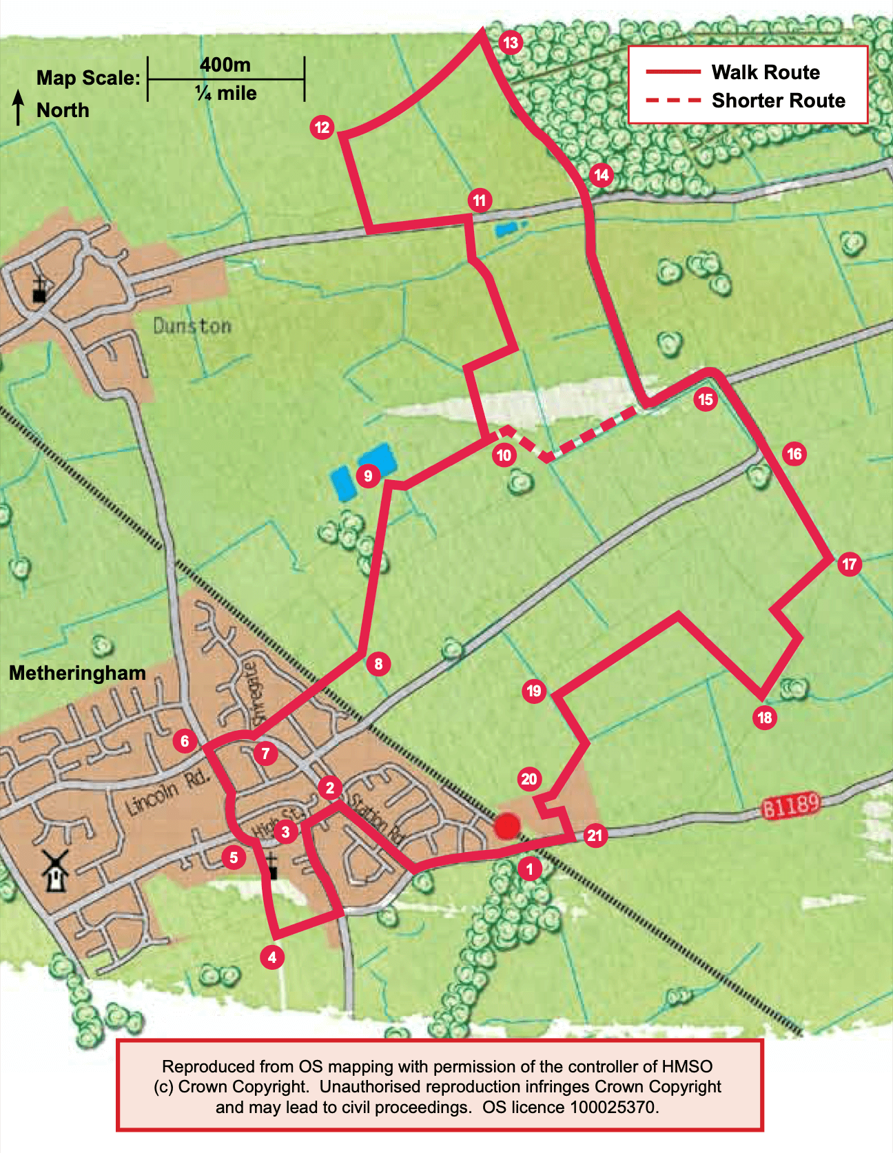
- 1Leave the Station and turn right. Walk along Station Road for approximately 650m.
- 2Turn left onto High Street (next to the petrol station).
- 3Turn left onto Drury Street and after approximately 300m and at a road junction turn right onto a public footpath.
- 4At a junction of footpaths and the corner of the cemetery turn right along the path towards the church.
- 5At the High Street turn left. Follow the High Street to its junction with Lincoln Road.
- 6Turn right and cross the road at the pedestrian crossing, turning right to continue in the same direction.
- 7Cross Shiregate and after 20m turn left onto the public footpath by the side of the pond. Just past the pond, at the junction of paths, continue straight ahead along the path behind the houses. Cross the road and follow the footpath almost straight ahead. Cross the railway line with care and continue along the path straight ahead.
- 8Cross the bridge and bear diagonally left across the field to a gate into the woodland. Follow the path through the wood and then out over a bridge and diagonally left across the field to another bridge. Cross the bridge and bear diagonally right across the field.
- 9At the field edge and junction with a restricted byway turn right.
- 10After approximately 300m, and at a junction with a footpath, turn left along the footpath and follow it as it bends. It will finally bend to the right, in front of a barn, to a road.
- 11Turn left along the road and after 300m turn right onto a restricted byway.
- 12After 300m and at a junction with a footpath turn right towards Nocton Wood.
- 13At the edge of the woodland turn right along a restricted byway.
- 14At the road continue straight ahead along Prior Lane. Follow the lane as it bends left then right.
- 15At a road junction, and grass triangle, continue straight on.
- 16At the next bend leave the lane and carry straight on along a restricted byway.
- 17After approximately 400m turn right onto a public footpath. Walk straight across the field to a hedge. Turn left and follow the field edge and then continue straight on into a small area of trees.
- 18Leave the woodland over a bridge and turn right. At the corner of the field cross the bridge and continue straight on. At the next corner turn left and walk along the field edge.
- 19Turn left at the field corner and after 150m turn right onto another footpath and then almost immediately turn left to follow the path around the edge of an industrial unit to a roadway.
- 20Follow the road through the industrial estate by turning left, left and then right to reach the road.
- 21Turn right and follow the roadside path back to the station.