


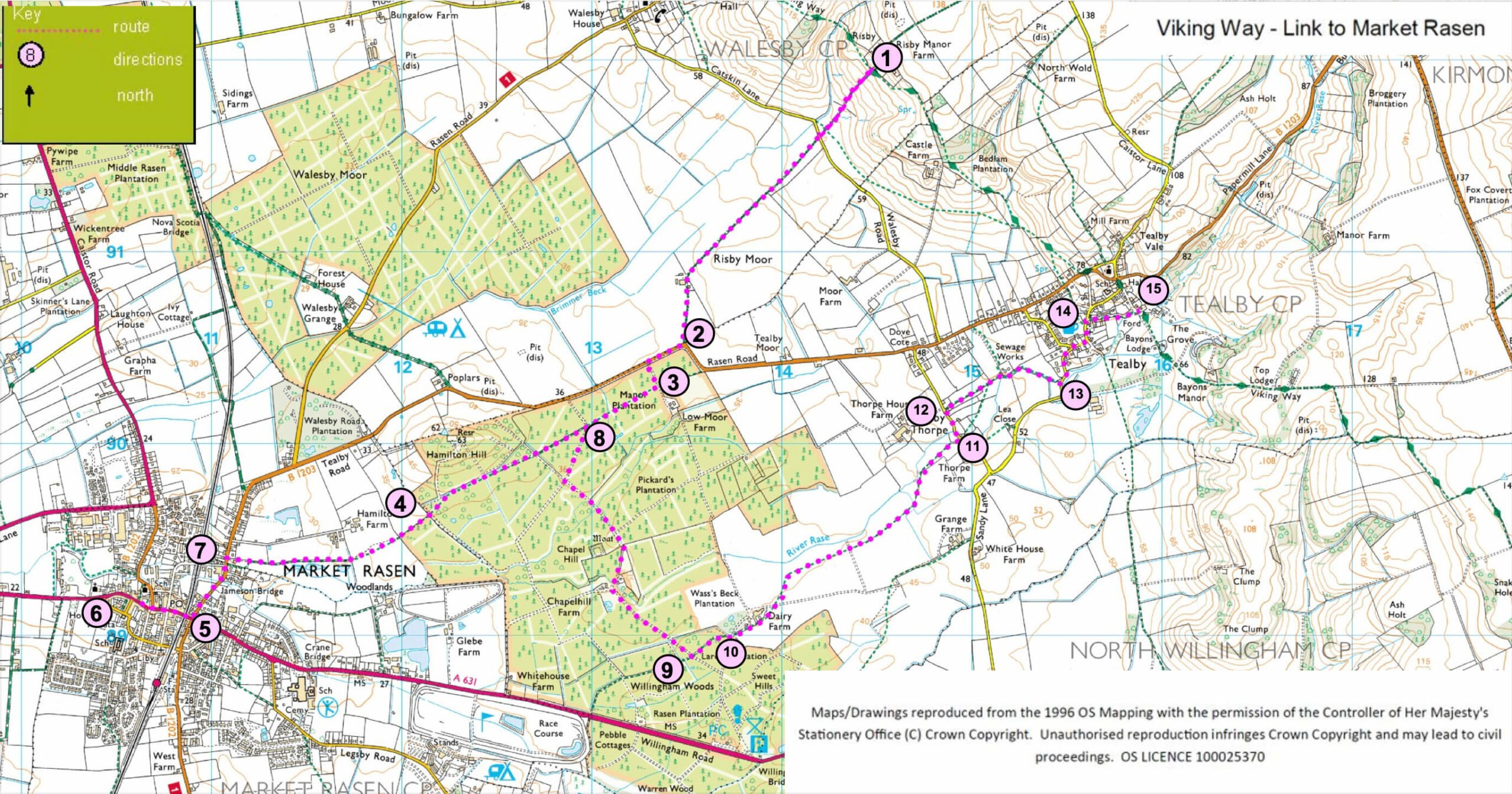
- 1Risby (Viking Way) to Market Rasen - At Risby, where the Viking Way crosses a bridleway (and farm drive), turn right off the Viking Way and follow the bridleway downhill to a road. Cross the road and continue straight ahead along the bridleway and track. Follow the bridleway between a house and barns and on to a road.
- 2Turn right and follow the roadside path for approx. 200m. Turn left onto track into the woods.
- 3After approx. 100m turn right onto a public footpath. Follow the path through the woods, ignoring tracks on the left and right, to the edge of the woods and a field (approx. one mile).
- 4Follow the footpath straight on across the field, beside flood ponds and on to a residential road. Walk straight on to a T-junction
- 5Turn left and at the traffic lights turn right to the centre of Market Rasen.
- 6Market Rasen to Tealby (Viking Way) - From the Market Square, with your back to the church, turn left along Queen Street. Go under the railway bridge and turn left along Jameson Bridge Street.
- 7Turn right onto the public footpath, opposite Waterloo Street, and follow it past flood ponds and across fields to enter Willingham Woods. Continue straight on along the public footpath through the woods. At a junction of paths and tracks continue straight on along the path (following the line of telegraph poles).
- 8At a junction with a forest track turn right and follow the track as it bears left. Just past the house and by the barn bear left keeping to the track for approx. 500m Turn left onto a public footpath.
- 9At the track bear left (ignoring the track on the left) along the farm road.
- 10Continue straight on past the houses and then bear left across the small field. Continue in the same direction across the next fields to a bridge. Cross the bridge and bear left across the first field and then bear right across the next field to a road.
- 11Turn left and walk past the ford.
- 12Turn right onto the public footpath and walk straight on along the field edges. At the sewage works bear right. Walk along the field edge, cross the river, to a road.
- 13Turn right onto the public footpath and walk straight on along the field edges. At the sewage works bear right. Walk along the field edge, cross the river, to a road.
- 14Turn right along The Smooting.
- 15At the road turn right to rejoin the Viking Way. (Turn left to visit the village shop).