(9.66 km)
Walking
Viking Way Shorts Cherry Willingham, Reepham and Fiskerton
Cherry Willingham, Reepham, Fiskerton
The Parade, Cherry Willingham
LN3 4JE
TF 031 727
what3words
 Parking
- Linked to Public Transport
 Refreshments
- Dog Friendly


Cherry Willingham
Welcome to Cherry Willingham! This large village on the outskirts of Lincoln has been around since the Norman invasion, recorded in the Domesday Book as ‘Gullingham’. The reference to cherries was added in 1373, when the village name was recorded as ‘Cherwellyngham’. The ‘Willingham’ refers to ‘a homestead belonging to the family of Willingas’ in Old English, while the Cherry refers to – you guessed it! Cherry trees, a word from Middle English.
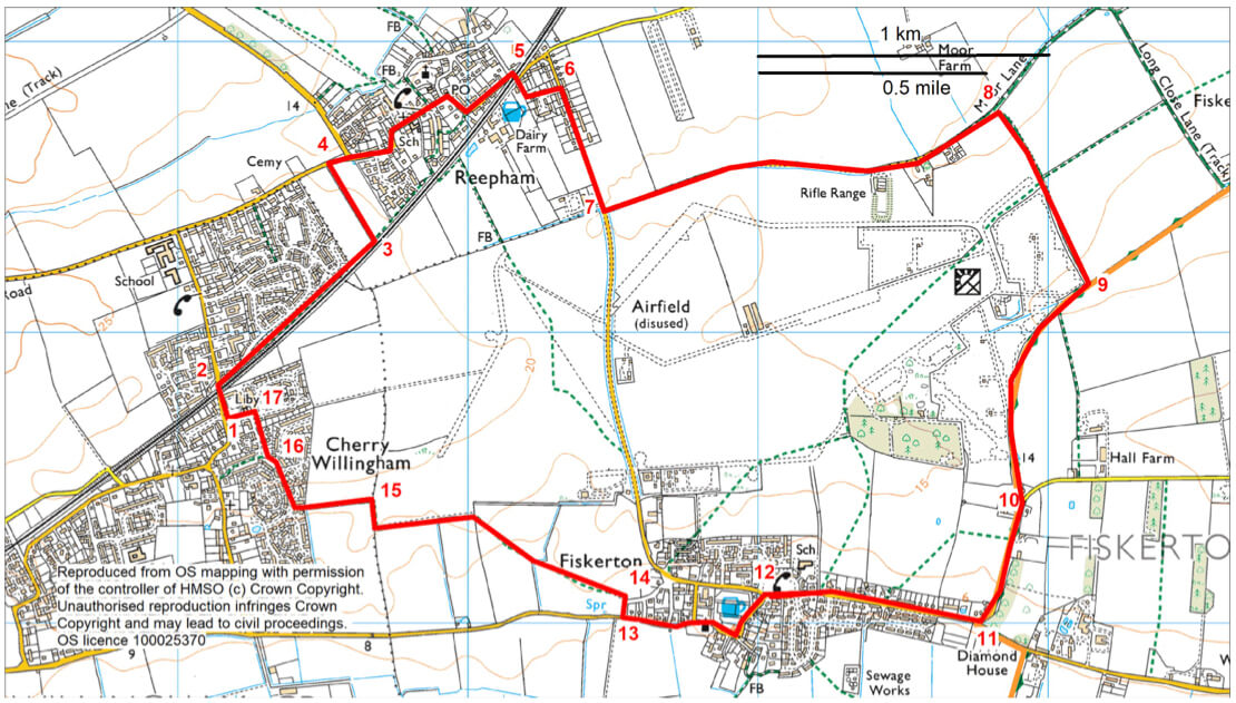
- 1From The Parade turn right and walk north along Croft Lane and over the level crossing.
- This railway was constructed by the Manchester, Sheffield and Lincolnshire Railway in 1848. The narrow-gated crossing dates to around 1900.
- 2Turn immediately right onto a public footpath and follow it beside the railway line for approximately 750m to a junction with another public footpath.
- 3Turn left and follow footpath along the field edge to a road.
- 4Turn right into Reepham village. Walk through the village along High Street and then Station Road.
Reepham
Reepham has existed since at least 664, mentioned in Anglo-Saxon charters. Its name there is Refham, and surprisingly this name has changed very little in the last 1500 years. The name means ‘reeve’s homestead’, referring to the reeve of Peterborough Abbey.
On the curve of High Street is a beautiful building from the mid-1700s, which has been turned into two cottages. Further along the road is the Reepham Methodist Church, which was originally built as a Wesleyan Methodist Chapel in 1893, and probably replaced an earlier chapel built on the same site. At the next curve of the road is Bartlegarth House opposite the village shop. It is striking looking building, which was originally built as a farmhouse in the late 18th century and underwent alterations in the 19th century. Three flakes of prehistoric flint were found in a garden nearby, suggesting there have been people working and living in the area for over 3000 years.
- 5Go over the level crossing and almost immediately turn right onto a public footpath between a house and bungalow and follow it to a road. Turn left to a T-junction.
- On the left hand side of you is the former Reepham Station. It was built in 1848 as part of the Lincoln to Barnetby Line, and operated for nearly 120 years, finally closing in 1965.
- 6Turn right. Walk along the pavement and the verge out of the village.
- In the area around you as you head out towards the fields, there is evidence for Romano-British activity. Finds such as pottery, spearheads, coins and a bronze brooch were found all over these fields. During excavations, ditches and gullies containing Roman finds were also uncovered. A geophysical survey in 2019 discovered more ditches and pits, which suggests there was a lot of Romano-British activity.
- 7Turn left onto a public bridleway and follow it along the tarmac lane and then grass track for approximately 1.5 km (nearly a mile) to a junction with another bridleway.
- Please note - this section of the route passes a rifle range. Shooting takes place when the red flags are flying.
- Look out for the planted hedges alongside the track. Hedges like these, using native species such as hawthorn, blackthorn and hazel are important as wildlife corridors. They form a link between areas of woodland. They are also important in themselves as places that wildlife can live, feed and shelter. As you near the turn off to the public bridleway, you enter the area of the former RAF Fiskerton. It was opened in January 1943 for the Lancaster squadrons based there. Nearly 2000 personnel were stationed here during the war. Buildings on the site included: a bomb dump, officers mess, gymnasium, chapel, naafi, living quarters, airmen’s mess, sergeants mess, WAAF living quarters and mess, mortuary, ambulance station and sewage works. It closed at the end of the war in 1945 and most of these buildings have been demolished.
- 8Turn right and follow the field edge to a junction with a public footpath.
- Continue straight ahead along the bridleway.
- 9At the junction with another bridleway and Viking Way turn right. The walk will now follow the Viking Way to Fiskerton village and then onto Cherry Willingham.
- Compare these hedges of hawthorn, blackthorn and elder to those planted earlier in the walk. You can see how a mature hedgerow is a great place for wildlife to make its home. In Autumn, the hedges will be full of berries which will attract a variety of birds.
- Follow the Viking Way between hedges to a junction with a tarmac lane.
- 10Turn right and follow the road to a T-junction.
- On your right is a view of Fiskerton, and further in the distance is Lincoln cathedral, a magnificent landmark that people have been spotting on the horizon from this very spot for nearly 1000 years.
- 11Turn right towards Fiskerton village.
Fiskerton
The village of Fiskerton is also mentioned in Anglo-Saxon Charters in 664 AD – in this it is recorded as – Fiskerton. Its name comes from ‘fiscere’, Old English for ‘fisherman’, and ‘tun’, which is Old English for an enclosure, farmstead, or village.
Fiskerton lies within the Lincolnshire Limewoods, an area that contains the most important examples of small-leaved lime woodland remaining in Britain. Many of the woodlands are designated a National Nature Reserve. Some woodlands date back to pre-historic times and provide a range of habitats for a wide variety of wildlife. An information board by the Village Hall has more information.
- Walk past the Village Hall to the Green.
- 12Bear left along the road signed Cherry Willingham.
- Walk past the pub and church.
- The St Clement’s Church of Fiskerton dates from the 11th century, with features from the 12th-17th centuries.
- Opposite the church to your right is the Manor House. This dates from the mid-18th century constructed of limestone rubble and red brick.
- 13Take the third road on the right, Plough Lane.
- 14At the top of the slope turn left onto a public footpath. Bear diagonally right across the first field to a bridge.
- Continue in same direction across the next field to the left of the field corner.
- Follow the path along the edge of the next field and at the corner turn right, through the hedge, and then left to follow the path beside the ditch and then turn right around the field corner.
- 15At a fingerpost turn left and follow the path to the road and Cherry Willingham village.
- Cherry Willingham was notable in the 14th and 15th centuries for its poverty. In 1342 the inhabitants had been exempted from tax ‘because of their poverty’ – though the villagers seemed to survive the Black Death. But it was still very small and poor. After the Second World War the village expanded rapidly from 15-20 households to 129 households. These numbers quadrupled over the later 20th century.
- 16Turn right and then right again along Dale Avenue to a T-junction.
- 17Turn left to The Parade.
At a leisurely pace this walk will take approximately three hours to complete. The walk uses a mixture of surfaced paths, tracks, field paths and roads. There are no stiles or livestock.
nearby walking routes
Bracebridge Walk
Branston To Lincoln Walk
Dunholme, Nettleham & Scothern Walk
Fiskerton Long Walk
Fiskerton Short Walk
Heighington Walk One
Heighington Walk Two
Scothern, Dunholme & Nettleham Dunholme Walk
Scothern, Dunholme & Nettleham Nettleham Walk
Scothern, Dunholme & Nettleham Scothern Walk
Stainfield & Apley Foxhall Wood Walk
Stainfield & Apley Hardy Gang Walk Long
Stainfield & Apley Hardy Gang Walk Short
Viking Way 08 Through Lincoln Walk
Viking Way 09 Lincoln To Wellingore Walk
map
more about the trail
Viking Way
The Viking Way is a long distance - 147 mile way-marked trail spanning from the River Humber through Lincoln to Oakham in Rutland. The route is signposted with an icon of a Viking helmet on a yellow disk.