


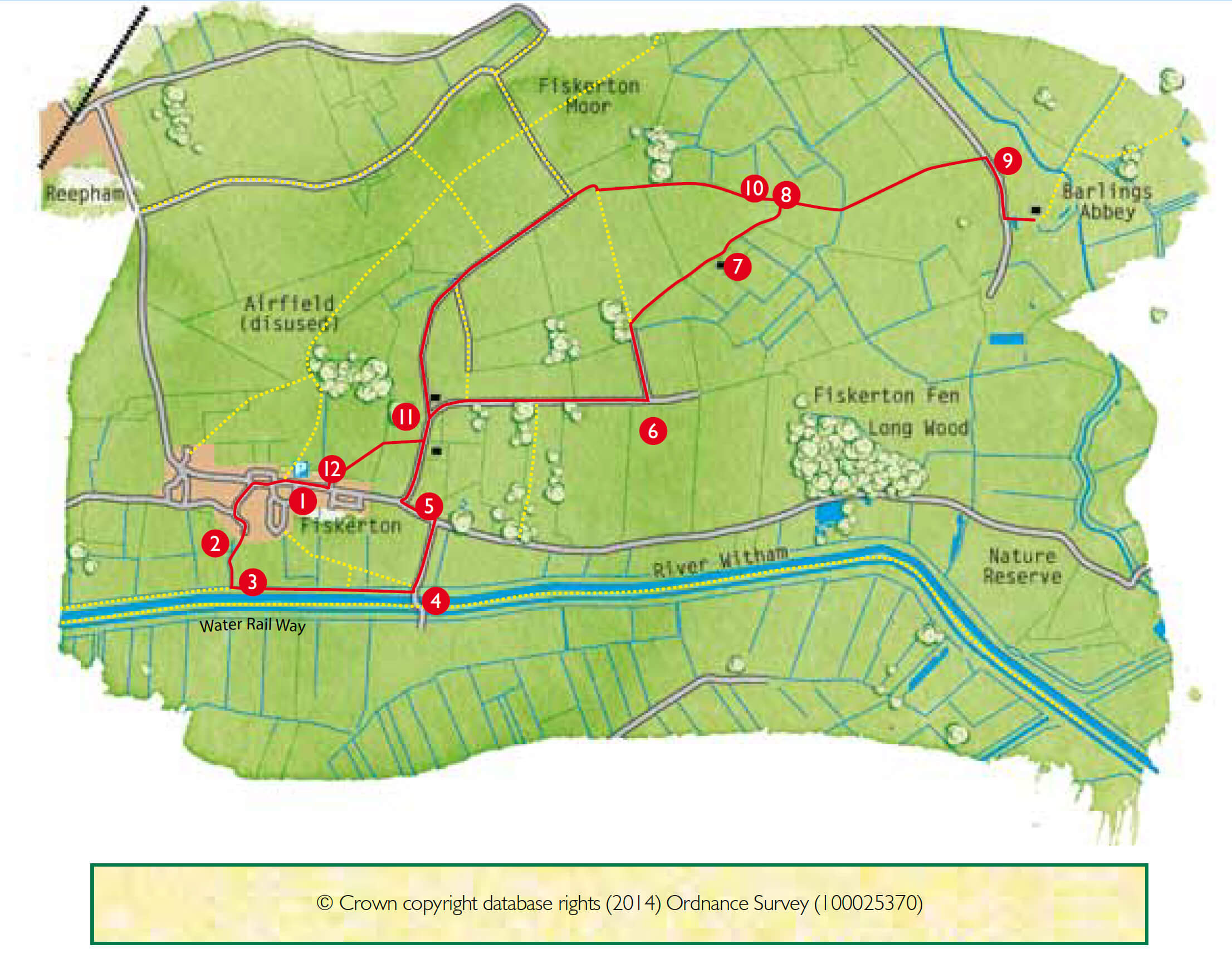
- 1With your back to the Village Hall cross the road, turn right and follow the road past the village green and pub. Turn left along Nelson Road.
- 2As the road bends to the left, turn right along the public footpath, between two houses, to emerge into a field. Turn right towards the River Witham and admire the view to the Cathedral on the right.
- 3Cross the bridge, climb up the bank and turn left along the public footpath on top of the bank beside the River Witham.
- 4At the footbridge over the river, turn left and follow the lane to a T-junction.
- 5Cross the road, turn left and take the first right along Hall Lane, a public bridleway. Continue along the lane ignoring first a public footpath, then a public bridleway and a second public footpath on the left and a public footpath on the right.
- 6At the end of the surfaced lane, after approximately one mile (1.5 kilometres) from the start of Hall Lane, turn left along the public bridleway. Walk straight on along the track, keeping the woodland on your left and ignoring the public bridleway on your left.
- 7When you reach the house at the end of the track, continue in the same direction on the bridleway along the field edge with the hedge and fence on your right. Walk for approximately 300m to the field corner and a gap in the hedge. Go through this and turn left, following the field edge to the corner where the bridleway meets a footpath.
- 8Turn right and walk across the field by bearing right towards the white cottages and bridge, when it comes into view. You are now walking on the Viking Way, Lincolnshire’s 147 mile long distance footpath that links the Humber to Rutland Water. Cross the bridge and bear slightly left to walk alongside the hedge (keeping it on your left) to the road.
- 9At the road turn right. After approximately 100m turn left onto a public bridleway towards Ferry House Farm. Turn right in front of the houses and through a gate to the remains of Barlings Abbey. Retrace your steps back to the road. Turn right and then left to return on the same footpath, over the bridge and across the field to the junction of paths and bridleway in the field corner.
- 10Continue along the bridleway in the same direction along the Viking Way (waymarked with a Viking helmet), through the gap in the hedge and then along a field edge and grass track. Go over a bridge and through a small copse. Continue on the Viking Way in the same direction along a hedge-lined path for about one mile (1.5 kilometres) ignoring a bridleway on the left, two on the right and a footpath on the left. Continue along the bridleway to emerge onto Hall Lane next to the bungalows.
- 11Turn right and after approximately 150m turn right onto the public footpath. Walk straight across the field to a gate in the hedge. Bear left across the next field heading towards the left-hand side of the bungalows. Go through the gap in the hedge and follow the path between the house and hedge to a road.
- 12Turn left and at the T-junction turn right and follow the road back to the Village Hall.