


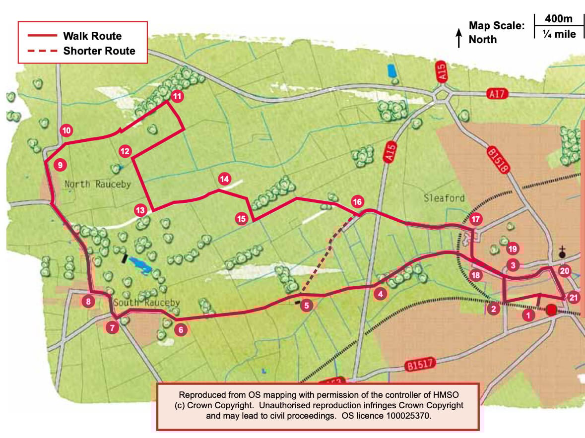
- 1Leave the station and cross the road. Turn left and then immediately right along a path between two fences. At the end of the path turn left, signed site of Sleaford castle.
- 2At the junction with a road turn right.
- 3Just after Electric Station Road turn left along the public footpath beside the river Slea. Follow the path beside the river, crossing over an old railway line, for approximately 0.75 miles (1.2 kilometres) to the junction with the A15.
- 4Follow the path to the right, cross the busy road with care, turn left and rejoin the path beside the river. Cross a footbridge and after approximately 250m, leave the river bank and bear right across the field to the end of the hedge.
- 5Walk straight ahead beside the fence, past the farm and along the field edges. At the junction of paths, at a track, continue straight on along the field edges for approximately 0.66 miles (1000m).
- 6Follow the path as it bears right into an area of woodland. Follow the path to the right past a metal sculpture (called In the Field) to a road and turn left.
- 7At a T-junction turn right and follow the road into the village.
- 8At the Bustard Inn turn right along Tom Lane and walk into and through North Rauceby village.
- 9At the end of the village turn right onto a public footpath opposite Chapel Lane. Bear diagonally left across the field to rejoin the road at the end of the old hedge line across the field.
- 10At the road turn right onto a public footpath and stone track. Follow the track along the field edges and then alongside a woodland. Walk alongside the woodland for approximately 300m.
- 11Turn right onto a public footpath that runs alongside a line of conifer trees.
- 12At the junction of tracks turn right along a footpath towards the spire of North Rauceby church. Follow the track as it bends left past more conifers.
- 13At the end of the track turn left along Drove Lane, an old Drove road.
- 14After approximately 600m turn right onto a public footpath into a field. Cross the field by bearing diagonally left towards a telegraph pole at the corner of the woodland. Go through the gap in the hedge and turn right, along a track beside the hedge, past the woodland and down the slope.
- 15At the field corner and track turn left. At a junction of paths bear right along the path and track and walk through the middle of a small area of woodland. Continue along the track past Drove Lodge.
- 16 At the junction with a tarmac lane turn left. Cross the A15 with care and go through the gap directly opposite. Follow the lane for approximately 0.5 miles (850m) and cross the railway bridge.
- 17Turn right onto a public footpath. Cross the estate road and continue straight ahead along the path to the river.
- 18Turn left and follow the riverside path to a road.
- 19Turn right and then left onto West Banks.
- 20At the junction with South Gate turn right. Follow the road through the town.
- 21Just before the large Memorial statue turn right along Nags Head Passage. At the end of the row of cottages turn left along the path to return to the station.