


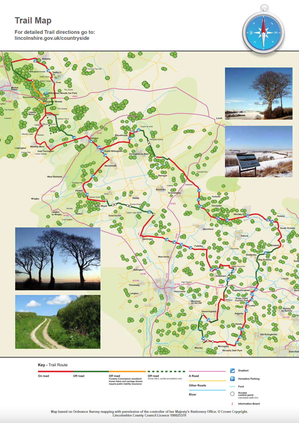
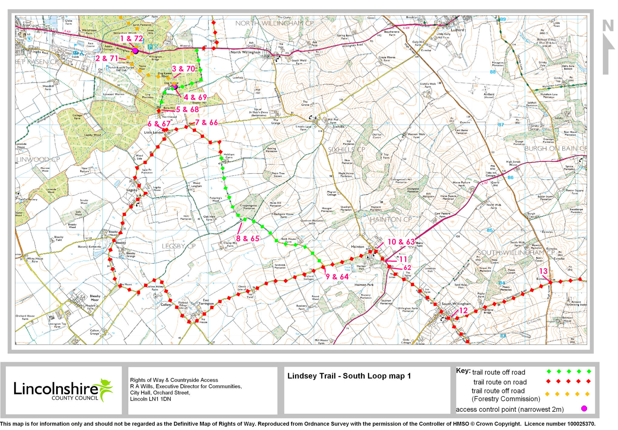
- 1Leave the western (Market Rasen) end of the car park. Turn left and cross the road. Continue straight ahead through a carriage gap. Follow the forest track to a T-junction.
- 2Turn left. At the next junction of tracks bear left. continue straight ahead for 1000m. Ignore the track on your left. Continue until you reach a T junction of tracks.
- 3Turn right. Go through the carriage gap.
- 4Turn right. Follow the byway past the houses to a road.
- 5Turn left. Follow the road for 0.25 miles (400m).
- 6Turn left, signed Sixhills. Follow the road for 0.3 miles (500m).
- 7Turn right onto a tarmac lane. Follow the lane as it becomes an unclassified county road (UCR). Follow it for 1.5 miles (2.4 km). You will come to a junction with a bridleway.
- 8Turn left. Follow the bridleway for 1.25 miles (two kilometres). You will come to a T junction with a road.
- 9Turn left. Follow the road to a T-junction.
- 10Turn right, signed South Willingham) and follow the road to a T-junction.
- 11Turn right (signed South Willingham. After 150m turn left, signed South Willingham. Go through South Willingham village.
- 12Turn left, signed Donington. Follow the road to a crossroads.
- 13Continue straight ahead, signed Donington for 0.6 miles (one kilometre).
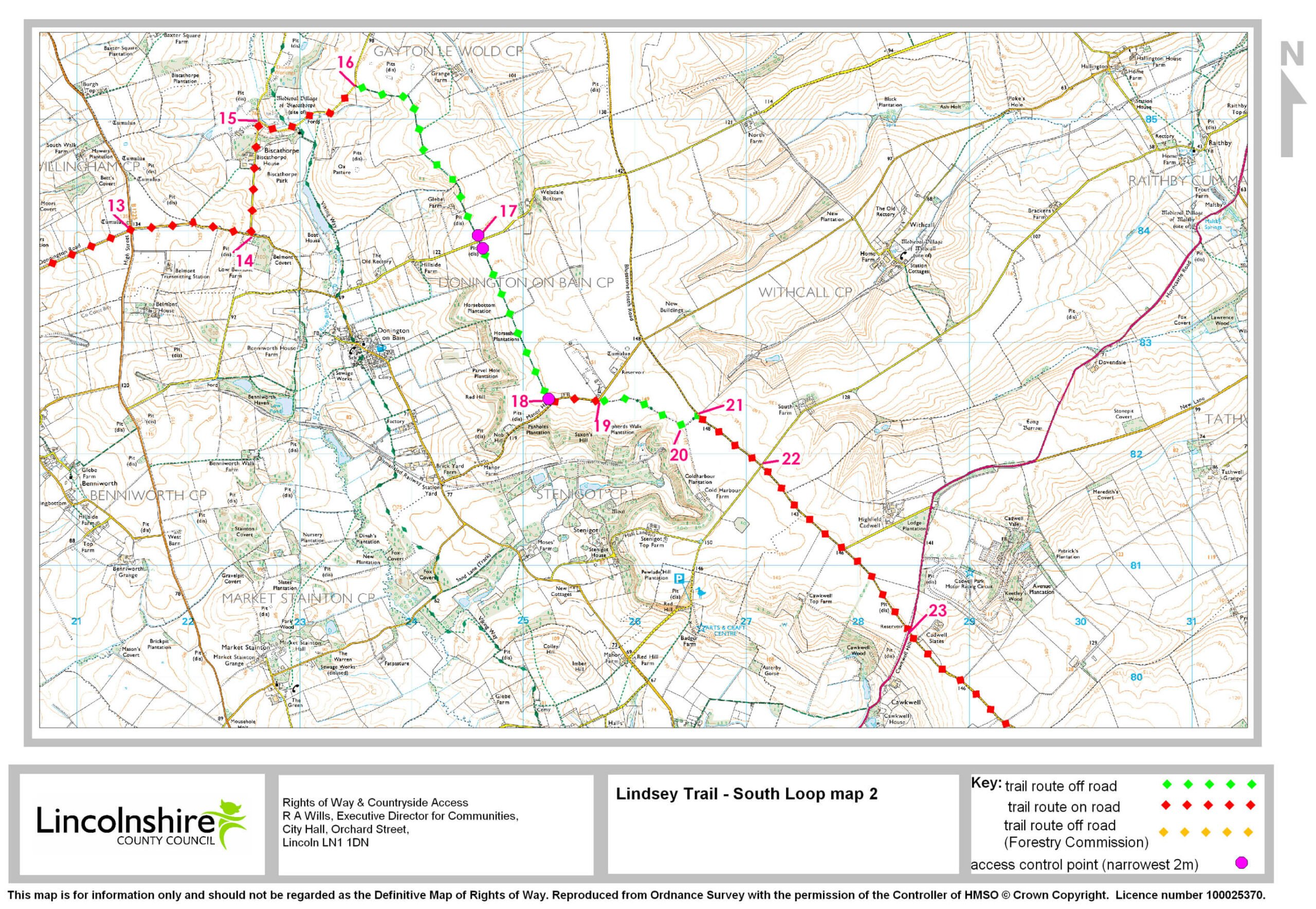
- 13Continue straight ahead, signed Donington for 0.6 miles (one kilometre).
- 14Turn left, signed Biscathorpe. Follow the road for 0.6 miles (one kilometre).
- 15Turn right, gated road. Go through two fords. Follow the road to the top of the hill.
- 16Turn right onto a track, signed public bridleway. Follow the bridleway for 1.25 miles (two kilometres) to a road.
- 17Go through the carriage gap. Cross the road. Go through another carriage gap. Continue along the track, signed public bridleway to reach a road.
- 18Go through the carriage gap. Turn left. Follow the road for 0.3 miles (450 m).
- 19By Stenigot mast, the road bends to the left. Leave the road by bearing right onto a UCR. Follow the track for 0.5 miles (800m).
- 20Turn left. Continue along the track to a road.
- 21Turn right. Follow the road to a crossroads.
- 22Continue straight ahead, signed Belchford. Continue to another crossroads.
- 23Continue straight ahead, signed Belchford. Follow this road for seven miles (11km).
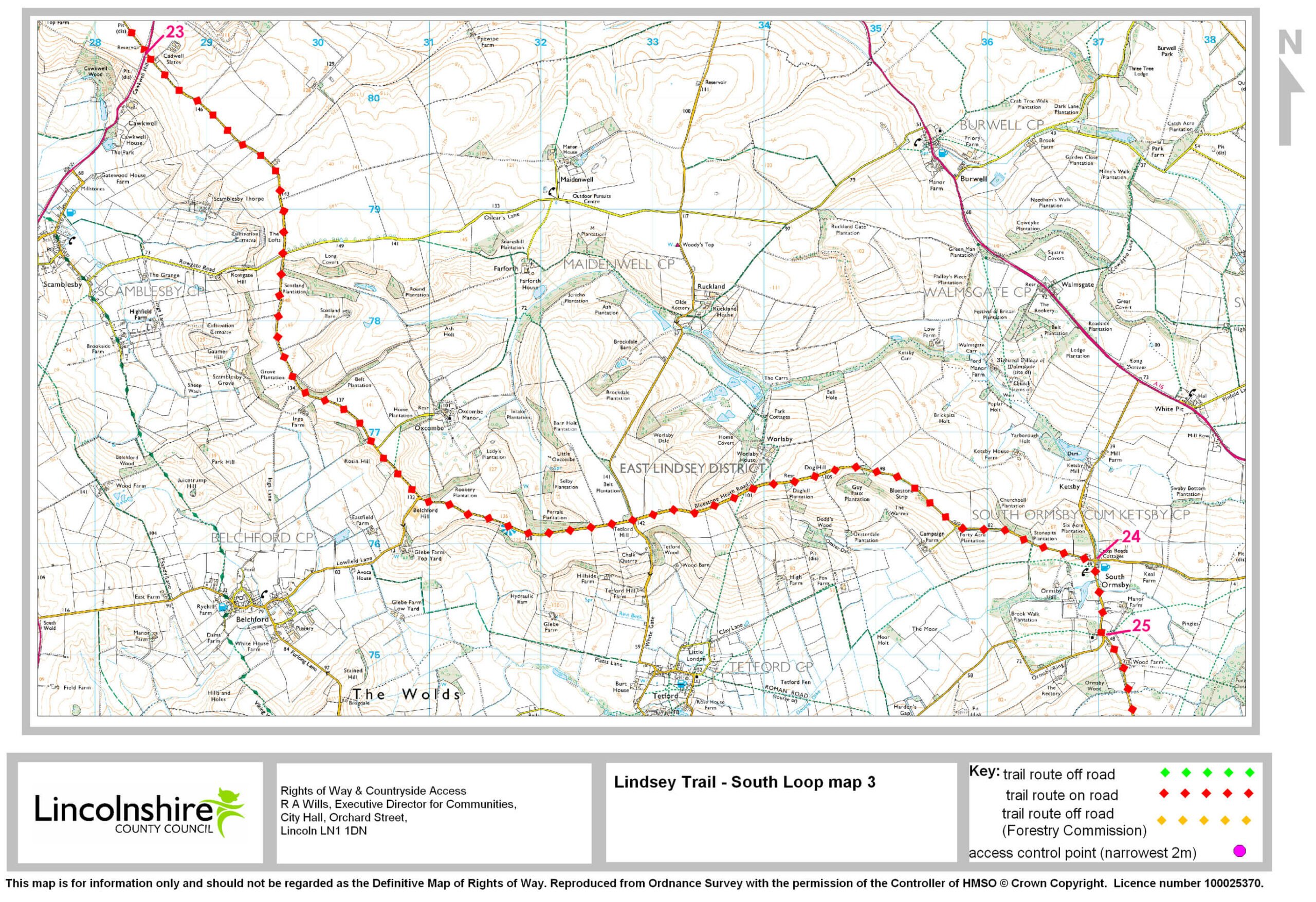
- 23Continue straight ahead (signed Belchford) and follow this road for seven miles (11km).
- 24Turn right, signed South Ormsby. Follow the road through the village.
- 25At the end of the village turn left, signed Brinkhill. Follow the road through Brinkhill village towards Horncastle.
- 25At the end of the village turn left, signed Brinkhill. Follow the road through Brinkhill village towards Horncastle.
- 26After the village, the road bends to the left. Leave the road here and turn right onto a track.
- 27Turn right onto a track, signed public bridleway. Follow the bridleway for 1.25 miles (two kilometres) to a road.
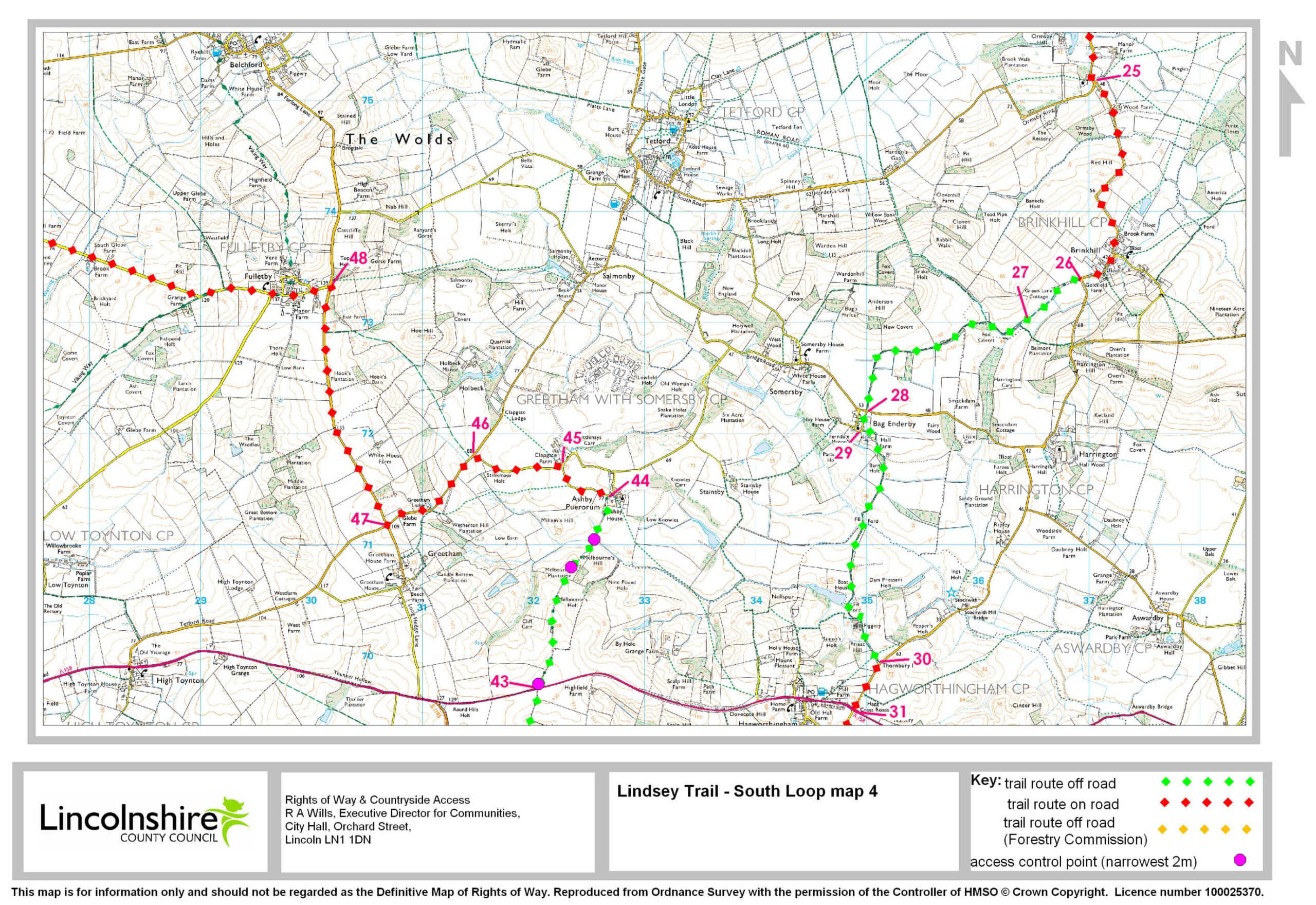
- 28Continue straight ahead, signed Bag Enderby.
- 29Where the road bends to the right leave the road by turning left onto a track (signed public bridleway). Follow the track. Go through two fords (or over the footbridges). Continue ahead as the track becomes a tarmac lane, to a T junction.
- 30 Turn right. Follow the road to a crossroads with the busy A158 at Hagworthingham.
- 31Cross straight over. Follow the road through the village to a T junction.
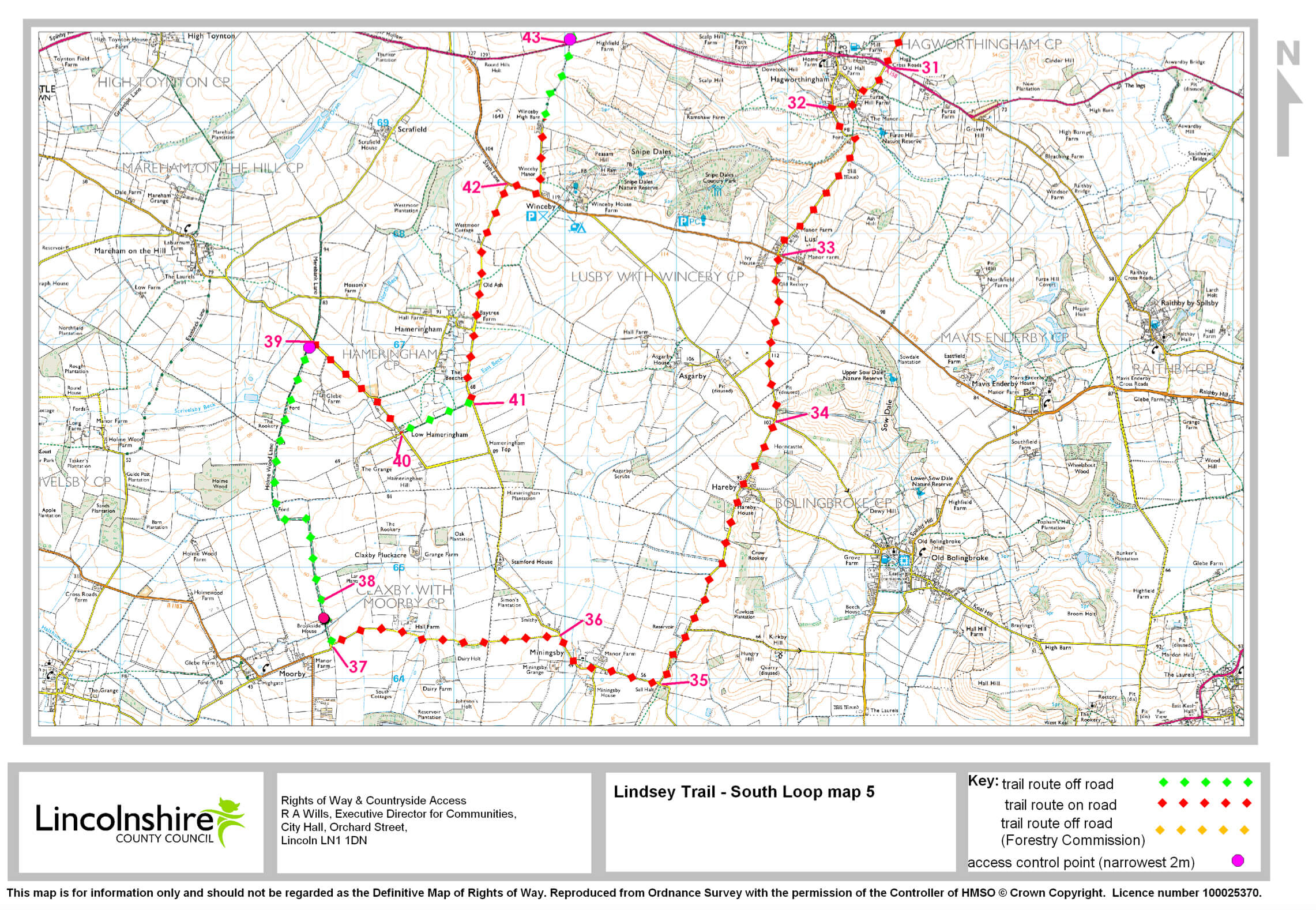
- 31Cross straight over. Follow the road through the village to a T junction.
- 32Turn left. Go through a ford (or over a footbridge). Follow the road to Lusby village and a crossroads.
- 33Continue straight ahead, signed Asgarby. Follow the road to a crossroads.
- 34Continue straight ahead, signed Hareby. At Hareby continue straight on, signed Miningsby. Follow the road to a T junction.
- 35Turn right, signed Miningsby. Follow the road for 0.6 miles (1000m).
- 36Turn left, signed Claxby Pluckacre. Follow the road for 1.3 miles (two kilometres).
- 37As the road bends to the left, turn right onto a track, signed public bridleway. Follow the track.
- 38Follow the track. Go through a carriage gap. Then two fords (or footbridges) to another carriage gap and road.
- 39Turn right. Follow the road for 0.75 miles (1.2km) through Low Hameringham.
- 40Turn left, signed public bridleway. Follow the track to a road.
- 41Turn left. Follow the road for 1.25 miles (2km) to a T junction.
- 42Turn right, signed Spilsby. After 300m and before the bungalow and garage turn left onto an unclassified county road. Follow the lane ahead as it passes a farm yard. It will become a field edge track to a junction with the busy A158.
- 43Cross the road. Continue straight ahead through a gate and onto a track. Follow the track into Ashby Puerorum and a junction with a road.
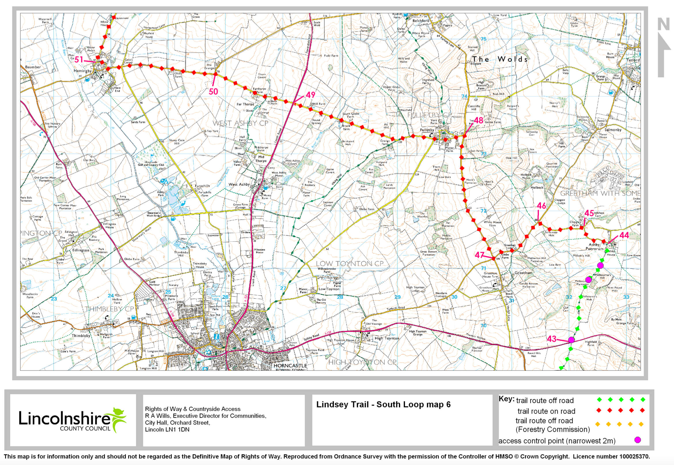
- 43Cross the road. Continue straight ahead through a gate and onto a track. Follow the track into Ashby Puerorum and a junction with a road.
- 44Turn left. Follow the road to a T junction.
- 45Turn left. Follow the road to a T junction.
- 46Turn left, signed Greetham. Follow the road to a cross roads.
- 47Turn right, signed Fulletby. Follow the road for 1.5 miles (2.4km) to Fulletby.
- 48Turn left, signed Horncastle. Follow the road to a crossroads with the busy A153.
- 49Cross the road. Continue straight ahead , signed Hemingby. You will come to a T junction.
- 50Turn left, signed Hemingby. Follow the road into Hemingby village. At the crossroads by the village hall turn right onto Chapel Lane Continue until you come to a T junction.
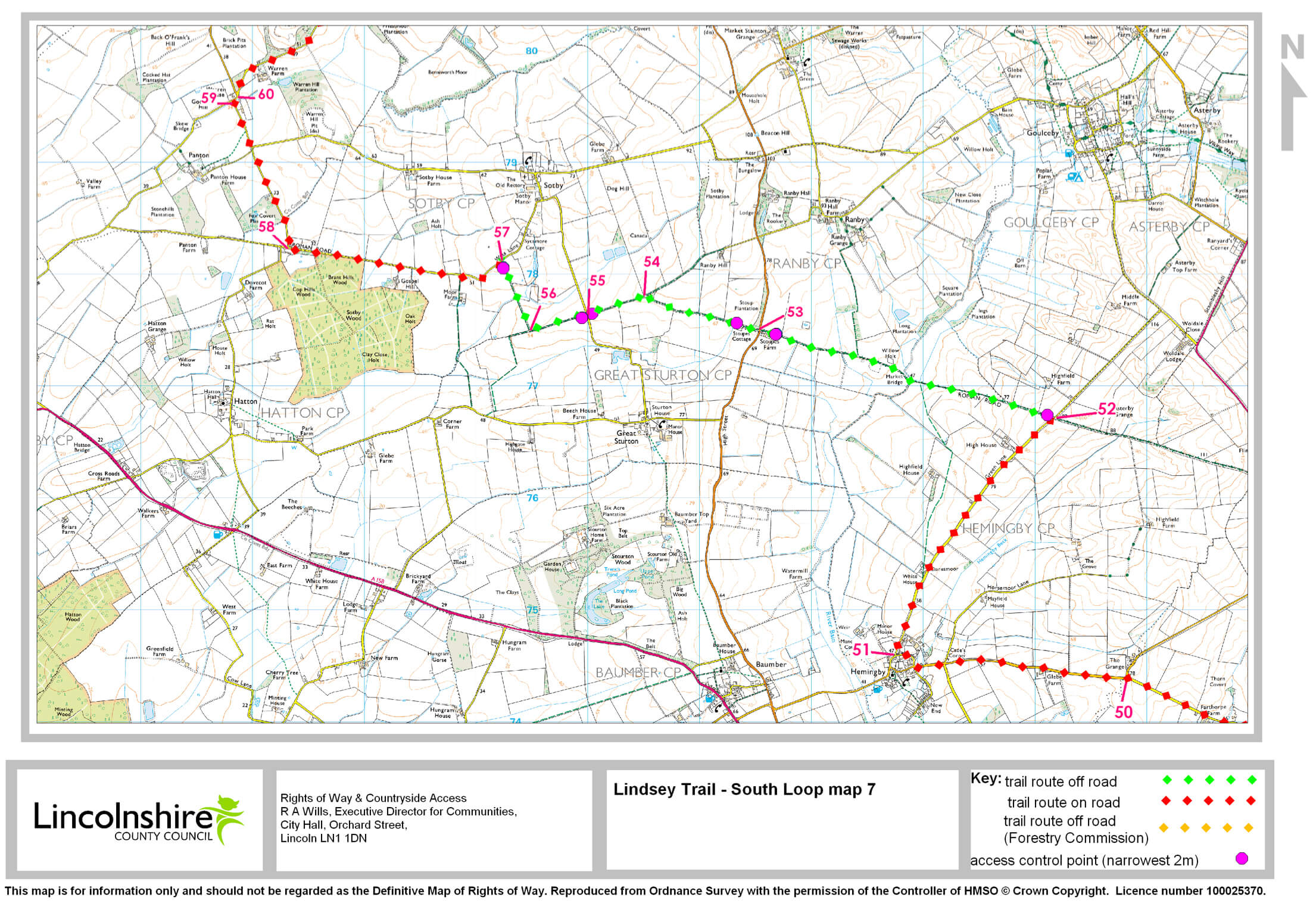
- 51Turn right, signed Goulceby. Follow the road for 1.75 miles(2.8km).
- 50Cross the road. Continue straight ahead through a gate and onto a track. Follow the track into Ashby Puerorum and a junction with a road.
- 51Turn right, signed Goulceby. Follow the road for 1.75 miles(2.8km).
- 52Turn left, signed restricted byway. Go through the gap and follow the track. Cross the river Bain. Continue along the track to a junction with a road.
- 53Cross the road. Continue straight ahead, signed restricted byway. Follow the track through a gap and for 0.5 mile (850m) to a junction with a bridleway.
- 54Turn left. Follow the track, through a gap to a road.
- 55Cross the road. Continue straight ahead, signed public bridleway. Go through a gap to follow the track for 0.3 mile (500m). Continue to a junction with another bridleway.
- 56Turn right. Follow the track to a gap and junction with a road.
- 57Turn left. Follow the road for 1.25 miles (two kilometres) to a road junction.
- 58Turn right, signed Panton. Follow the road for one mile (1.6 km) to a T junction.
- 59Turn right, signed Benniworth. Follow the road for 100m.
- 60Turn right, signed Benniworth. Follow the road for 2.5 miles (four kilometres) to a crossroads.
- 59Turn right, signed Benniworth. Follow the road for 100m.
- 60Turn right, signed Benniworth. Follow the road for 2.5 miles (four kilometres) to a crossroads.
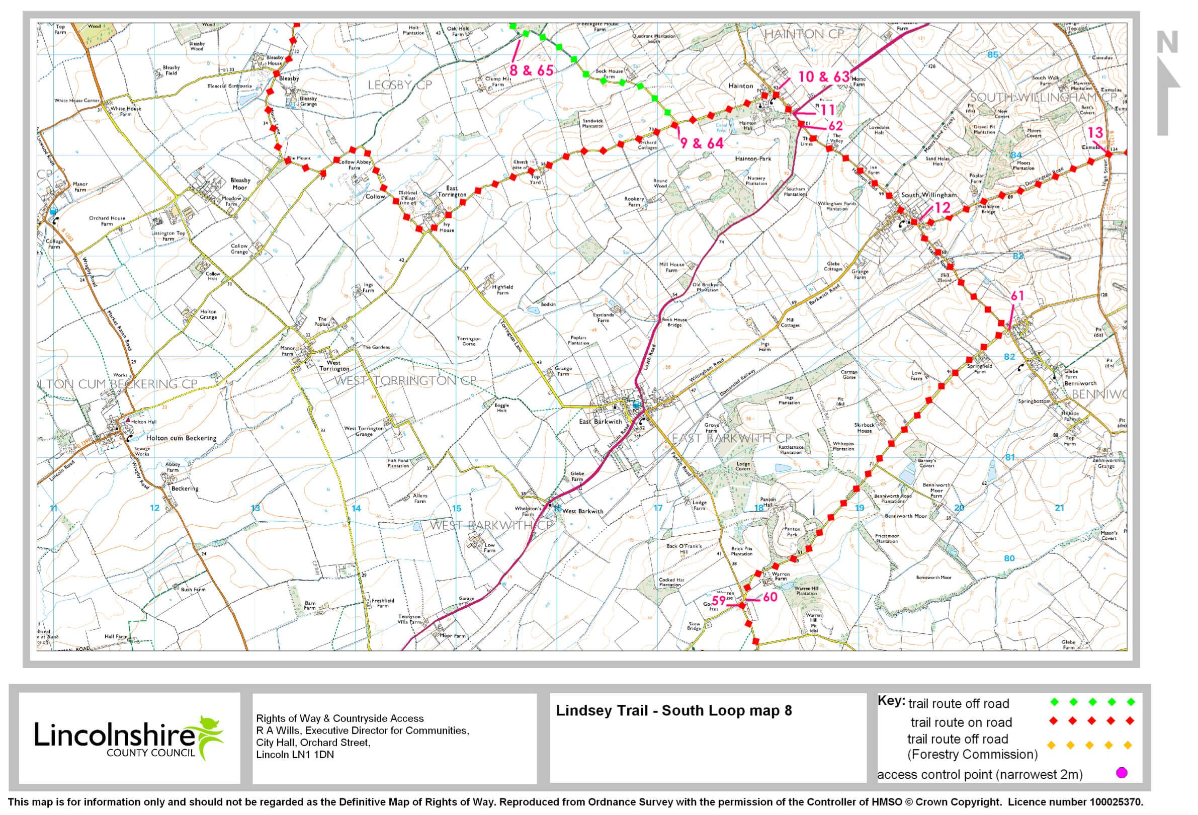
- 61Turn left, signed South Willingham. Follow the road through South Willingham village. Continued on to a T junction with the A157 at Hainton.
- 62Turn right, signed Hainton. After 150m turn left, signed Hainton & Sixhills. Follow the road for 300m to a junction.
- 63Turn left, signed East Torrington. Follow the road for 0.66 miles (one kilometre).
- 64Turn right, signed public bridleway. Follow the track for 1.2 miles (1.9 km) to a junction where the bridleway meets an un classified county road (UCR).
- 65Turn right onto the UCR. Continue straight ahead as the track becomes a tarmac lane to a T-junction.
- 66Turn left. Follow the road to a T-junction.
- 67Turn right, signed Market Rasen. Follow the road to where it bends sharp left.
- 68Leave the road by turning right onto a public byway and into Dog Kennel Wood. Follow the byway as it bears right in front of the houses. Continue to the end of the paddocks.
- 69Turn left through a carriage gap. Follow the track for 200m to a junction of tracks.
- 70Turn left. Follow the track to a T junction and turn right. Follow the track for 0.25 miles (450m).
- 71Turn right towards the road.
- 72Leave the woodland through a carriage gap. Cross the road to return to the starting point.
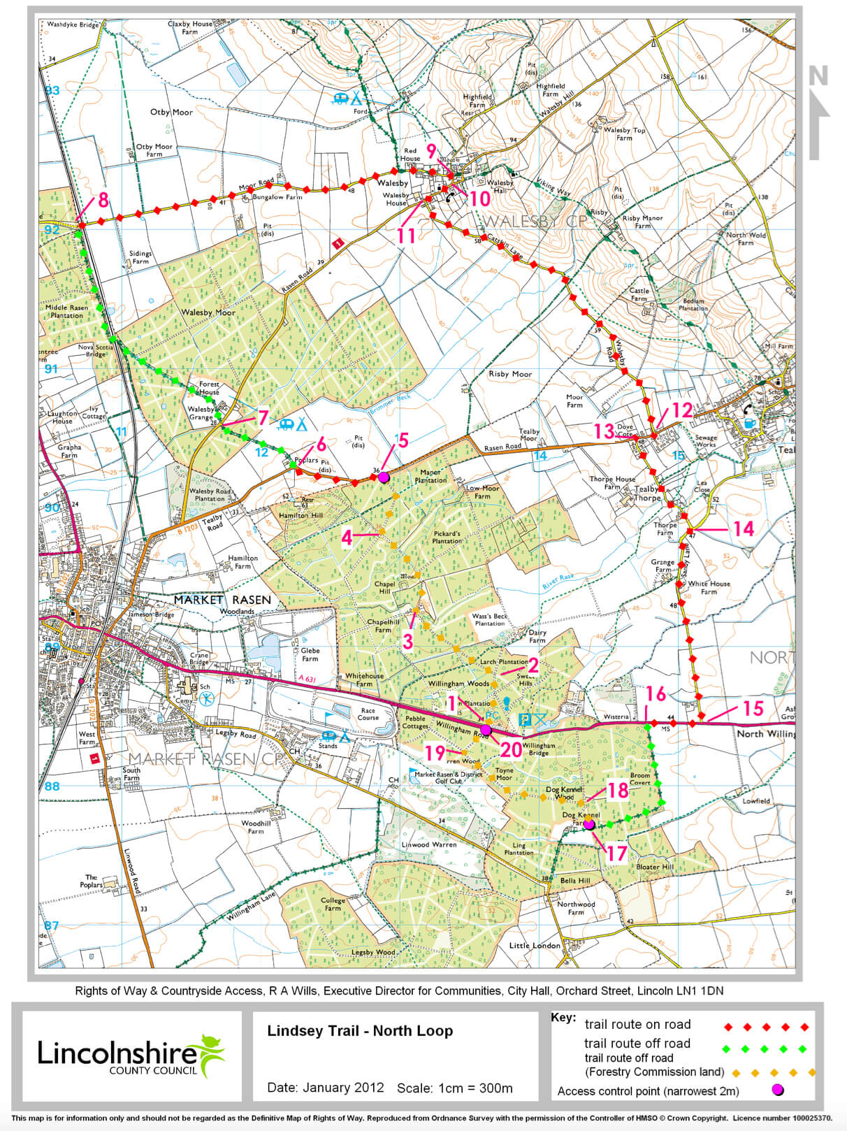
- 1Leave the western (Market Rasen) end of the car park. Turn right on to the forest track, away from the road. Follow the track for 400m. Continue to a crossroads of tracks.
- 2Turn left.
- 3At the red-brick building bear right. There will be a T junction of tracks. To visit Chapel Hill moated site, turn left. This is approximately 300m after the buildings.
- 4Turn right. Follow the track to a road. There is a carriage gap to exit the woodland.
- 5Turn left onto the road. Continue for 650m.
- 6Turn right on to a public byway. Follow the byway past Sunnyside Up Farm Shop. Continue through the woods to a road.
- 7Cross the road. Continue on the byway for approximately 1.25 miles (two kilometres). You will come to a road.
- 8Turn right. Go over the level crossing. Follow the road into Walesby. Continue to the crossroads next to the village hall.
- 9Turn right, signed Tealby. Follow the road to a T junction.
- 10Turn right, signed Tealby. Follow the road for 250m.
- 11Turn left, signed Tealby. Follow the road for 1.5 miles (2.5 km). Continue to the T junction.
- 12Turn right, signed Market Rasen. Follow the road for 150m.
- 13Turn left along Thorpe Lane. Follow the road through a ford. Continue to T junction.
- 14Turn right. Follow the road to a T junction with the A631.
- 15Turn right, signed Market Rasen. Follow the road for 400m.
- 16Turn left on to a public byway. Follow the track for 0.6 miles (one kilometre).
- 17Turn right through a carriage gap. Continue through the woodland. Follow the forest track for 200m. Continue to a junction of tracks.
- 18Turn left. Follow the track to a T junction. Turn right. Follow the track for 450m.
- 19Turn right on to another track towards the road.
- 20Leave the woodland through a carriage gap. Cross the road. Return to the starting point.
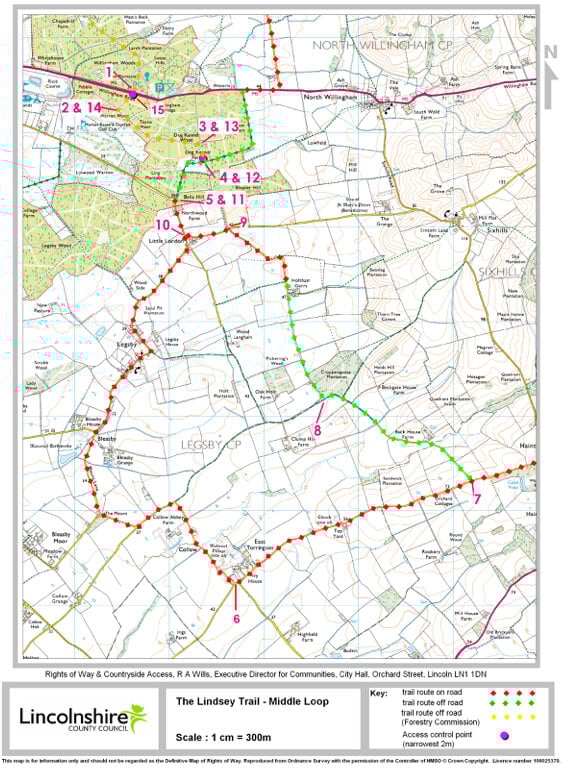
- 1Leave the western (Market Rasen) end of the car park. Turn left and cross the road. Continue straight ahead through a carriage gap and onto a forest track. Follow the track to a T-junction.
- 2Turn left. At the next junction of tracks bear left. Continue straight ahead for 1000m. Ignore the track on the left. You will come to a T-junction of tracks.
- 3Turn right. Follow the track. Go through the carriage gap to a T-junction.
- 4Turn right. Follow the byway past the houses to a road.
- 5Turn left. Follow the road through Legsby. Continue straight on towards East Torrington.
- 6In East Torrington turn left (signed Hainton). Follow the road for 1.75 miles (2.8km).
- 7Turn left onto a lane (signed public bridleway). Follow the track for 1.2 miles (1.9 km) to a junction. At the junction the bridleway meets an unclassified county road (UCR).
- 8Turn right onto the UCR. Continue straight ahead on the track. The track becomes a tarmac lane to a T-junction.
- 9Turn left and follow the road to a T-junction.
- 10Turn right (signed Market Rasen). Follow the road to where it bends sharp left.
- 11Leave the road by turning right. Continue onto a public byway and into Dog Kennel Wood. Follow the byway as it bears right. Continue in front of the houses and to the end of the paddocks.
- 12Turn left through a carriage gap. Follow the track for 200m to a junction of tracks.
- 13Turn left and follow the track to a T-junction. Turn right. Follow the track for 0.25 mile (450m).
- 14Turn right towards the road.
- 15Leave the woodland through a carriage gap. Cross the road to return to the starting point.