


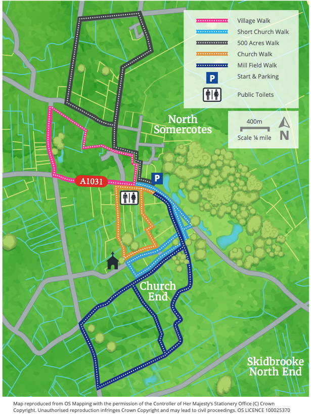
- 1From the village hall walk into the village past the war memorial and turn right along Brown's Lane. Follow the path straight on in front of the houses to junction with a track. Turn left, in front of Humberstone Villas, and follow the path around to the right to the junction. Turn left and follow the footpath and road to a T-junction.
- 2Turn right and where the road bends left, continue straight on along a footpath and Wembley Road.
- 3Follow the unmade road past the houses on the left and then follow the path between two hedges.
- 4Where the double hedge ends, turn right across a field before crossing ‘Cradle Bridge’ where the path turns half right between two fields. To the left you will see part of the old RAF Donna Nook buildings.
- 5The path will shortly turn left and you will pass through the old camp area to the road.(* if you would like to extend this walk see longer option below).
- 6Turn left and follow this road to a T- junction.
- 7At the T-junction turn left and continue to the junction of this road with Bank End and Cemetery Road.
- 8Turn left and on your right you will pass the village Cemetery and its unusual twin chapels.
- 9Continue along Cemetery Road as it bends to the right to become Churchill Road and a T-junction with Keeling Street.
- 10Turn left to return to the Village Hall.* longer option (adds 4 km - 2.5 miles to the walk).
- 11At this junction, if you wish to extend your walk - and see the sea - cross the road and follow the long straight Donna Nook Road ahead. Towards the end and to the right you will see the old Coast Guard Houses and the lookout.
- 12Follow the road as it bends left, and at the next junction turn right to reach Stonebridge car park and access to the beach and Donna Nook National Nature Reserve. Caution: Live Firing - you must observe the Range Danger Boards and Red Flags at all times. It stretches from Grainthorpe Haven in the North to Saltfleet in the South.
- 13To return to North Somercotes leave the car park and follow the road straight ahead (Marsh Lane) to the junction of this road with Bank End and Cemetery Road.
- 14Turn left and continue along the road as it bends to the right along Churchill Road to a T-junction with Keeling Street.
- 15Turn left to return to the Village Hall.