Walking

Stamford Four Counties Walk One

A lovely circular walk taking in 4 counties! Though the start and finish of the walk are in Lincolnshire, you will also be walking in Rutland, Northamptonshire and Peterborough in Cambridgeshire. The walk takes you along the banks of the River Welland and up onto higher ground at Easton on the Hill, where there are good views back over Stamford and to the Fens beyond. The walk goes through attractive woodland at Wothorpe and ends with a fine approach to the town.

Starting point
Tourist Information Centre (TIC) and Arts Centre
St Mary’s Street,
Stamford
PE9 2DL

  • ParkingParking
  • Linked to Public TransportLinked to Public Transport
  • RefreshmentsRefreshments
  • Dog FriendlyDog Friendly

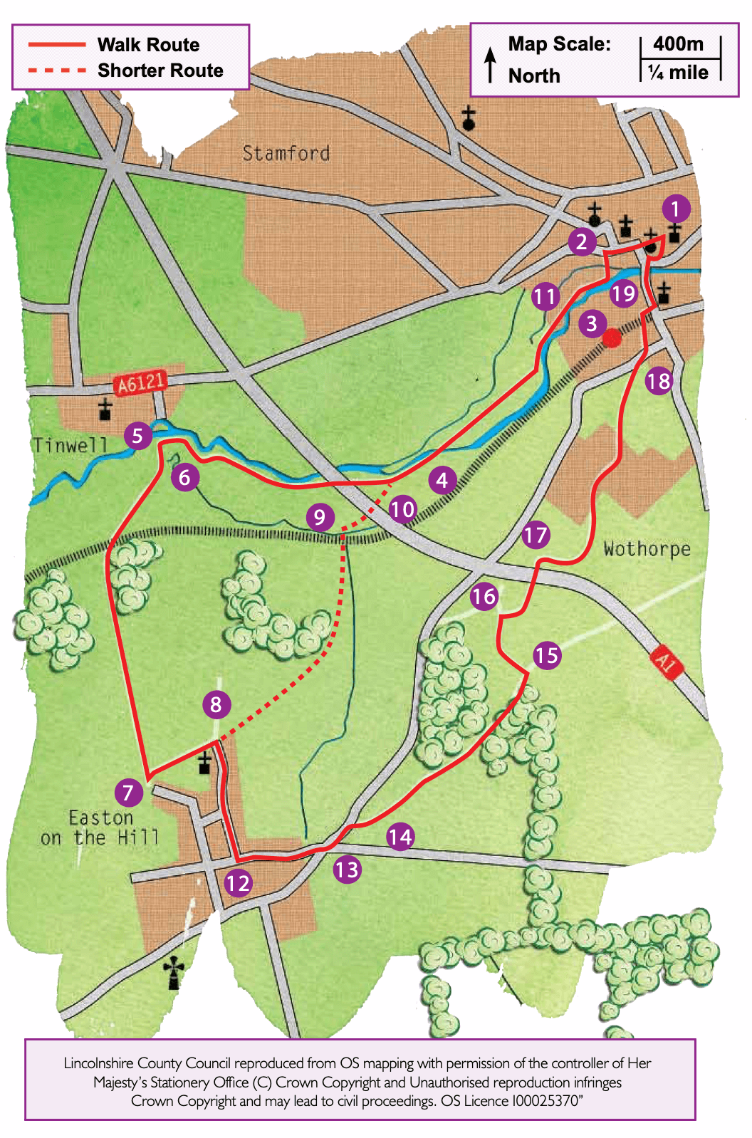
Stamford has long been considered one of the most beautiful of England’s smaller towns, with over a thousand years of history to its name. Springing up where the Great North Road crosses the River Welland, it prospered in the Middle Ages through trade in wool and a much sought after woven cloth called haberget. Indeed, in the 13th century Stamford was one of the ten largest towns in England, boasting a castle, fourteen churches, two Benedictine religious houses and four friaries.

After a period of decline the town’s fortunes were revived by improvements to the Great North Road in the 17th and 18th centuries. Most people travelling north or south passed through Stamford.  It soon developed coaching inns, stabling and related trades to support the seventy or so stage and mail coaches passing through every day.  Prospering merchants and lawyers built many of the fine houses that can still be seen today.

The river Welland rises in Leicestershire and flows eastwards to enter The Wash. This meadows area is part of a floodplain lying between two tributaries of the river that rejoin just before the Town Bridge. Look out for the old Roman crossing point on your left, on a direct alignment with Ermine Street and now marked by a stone plaque.

The picturesque village of Easton on the Hill was recorded in the Domesday Book as ‘Estone’. All Saints Church dates from the 12th century, although it has been much enlarged and altered over time. The Royal Air Force established a training depot at Easton as far back as 1917. Later renamed RAF Collyweston, it was eventually absorbed into neighbouring RAF Wittering.

Wothorpe Groves and Pit Holes are expanses of mixed deciduous woodland. They provide excellent habitats for a wide range of woodland birds, mammals and wild flowers.

Wothorpe Towers was built in the early part of the 17th century by Thomas Cecil, Earl of Exeter, to “retire to out of the dust whilst his great house of Burghley was a sweeping.”

The bridge at point 4 of this walk is currently closed for repair. Alternative routes are shown at the location or check the map

  • 1Leave the TIC, cross the road and turn left along St Mary’s Street. At the T-junction carry straight on and then cross the road at the pedestrian crossing and continue to walk in the same direction. Where the road bends to the right, continue straight on along Castle Street.
  • 2At Sheepmarket Square turn left along Castle Dyke. At the end of the road continue straight on over the bridge and follow the surfaced path across the meadow.
  • 3Just before the next bridge turn right and walk along the bank of the river. Continue across the meadows for approximately half a mile (one kilometre) to reach another footbridge (Broadeng Bridge).
  • 4Cross the bridge and bear right to follow the river, now on your right. Continue alongside the river for approximately ¾ mile (1.2 kilometres), passing through a bridge arch under the A1, to reach a junction of paths and bridge into Tinwell village.
  • 5Turn left onto the bridleway that runs along the field edge.
  • 6After approximately 100m turn right along a track, with tall hedgerows on either side. Cross the railway line with great care and continue up the hill, along the track.
  • 7At the top of the slope, just outside the village of Easton on the Hill and immediately before some allotments on the left, turn left along a wide track towards the church.
  • 8On reaching a lane by the church, turn right.
  • 12At the junction with High Street, marked by a stone war memorial, turn left and continue ahead to the junction with the A43.
  • 13Turn left here and walk along the pavement for approximately 100m.
  • 14Take the bridleway to Wothorpe that goes off to the right, crossing the main road with extreme care. Walk through the woodland for approximately two thirds of a mile (one kilometre) to a junction of two bridleways.
  • 15Turn left to walk around the remains of Wothorpe Towers.
  • 16At a track and junction with a public footpath turn right and follow the path into a field and follow the fence line in front of the cottage. At the end of the fence continue ahead, aiming for the right hand corner of a barn in the corner of the field. At the barn turn left and follow the path under the A1.
  • 17At the end of the tunnel turn right and walk alongside a hedge and parallel to the A1. At the corner of the field follow the path left to a stile in a field corner. Bear left across a small field to a stile and bridge. Cross the bridge and follow the path to a road. Follow the road to a T-junction. Cross the road and take the public footpath almost opposite to a field. Cross the field towards a gate in the corner. Bear right across a small bridge and follow the path to a road.
  • 18Cross the road with care and walk along Wothorpe Road before bearing right along Church Lane. At the end of Church Lane turn right and at the T-junction turn left.
  • 19Having crossed the river, using the Town Bridge, turn right onto St Mary’s Place, still cobbled, between the Town Hall and St Mary’s Church.

The walk uses roadside paths, field paths and tracks. The railway line is crossed once. You will encounter stiles and livestock.

more information

Starting point

Tourist Information Centre (TIC) and Arts Centre

St Mary’s Street,

Stamford

PE9 2DL