


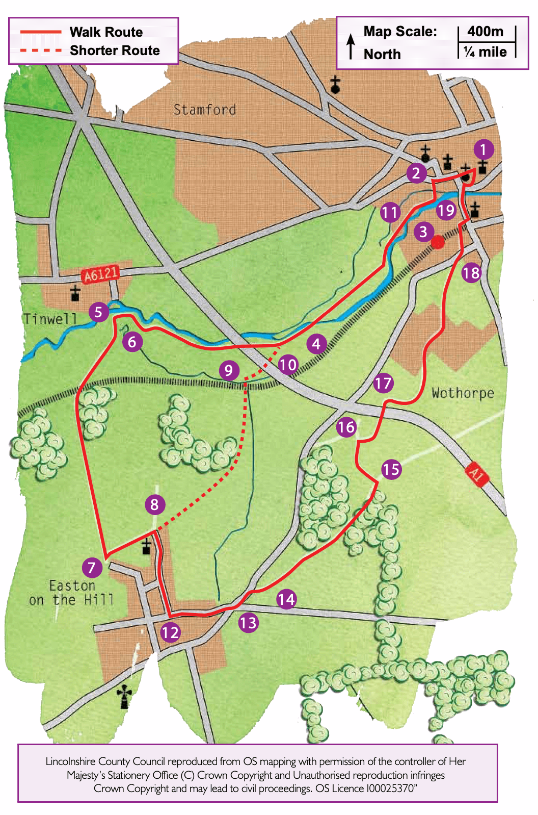
- 1Leave the TIC, cross the road and turn left along St Mary’s Street. At the T-junction carry straight on and then cross the road at the pedestrian crossing and continue to walk in the same direction. Where the road bends to the right, continue straight on along Castle Street.
- 2At Sheepmarket Square turn left along Castle Dyke. At the end of the road continue straight on over the bridge and follow the surfaced path across the meadow.
- 3Just before the next bridge turn right and walk along the bank of the river. Continue across the meadows for approximately half a mile (one kilometre) to reach another bridge (Broadeng Bridge).
- 4Cross the bridge and turn right to follow the river, now on your right. Continue alongside the river for approximately ¾ mile (1.2 kilometres), passing through a bridge arch under the A1, to reach a junction of paths and bridge into Tinwell village.
- 5Turn left onto the bridleway that runs along the field edge.
- 6After approximately 100m turn right along a track, with tall hedgerows on either side. Cross the railway line with great care and continue up the hill, along the track.
- 7At the top of the slope, just outside the village of Easton on the Hill and immediately before some allotments on the left, turn left along a wide track towards the church.
- 8On reaching a lane by the church, turn right. Then turn left almost immediately to follow a public footpath across a parking area. At the field bear left, across the field corner, following way markers denoting long distance footpaths. Bear right across the corner of the next field, aiming just to the right of three telegraph poles. Go through a gap in a hedge and continue down the hill on a track along the field edge, with Stamford ahead. Pass through a wooded area and continue ahead across a large field, aiming for the way marker post in the distance.
- 9Follow the path through an area of scrub to reach the railway line on an embankment. Cross it with care and then bear right to cross the corner of another field. Cross a footbridge and go through the tunnel under the A1. Continue ahead to reach the river.
- 10You have now rejoined your outward route. Simply turn right and continue along the path by the river, now on your left, towards Broadeng Bridge and the Meadows. Walk back through the Meadows alongside the river to the junction with a surfaced path and bridge.
- 11Turn left, cross a bridge and continue straight ahead along Castle Dyke to Sheepmarket Square. Turn right along Castle Street and continue straight on along St Mary’s Street to return to the starting point.