Walk
Loop
5miles
(8.05km)
2 hours
30 mins

Walking

Stamford River Walk

Stamford, Uffington

From the beautiful stone town of Stamford you will walk close to the river before returning alongside the dried bed of Stamford canal. This is a circular route. The route is shown in red on the map.

Starting point
Tourist Information Centre (TIC) and Arts Centre
St Mary’s Street
Stamford
PE9 2DL
Grid reference TF 031 070

  • ParkingParking
  • Linked to Public TransportLinked to Public Transport
  • RefreshmentsRefreshments
  • Dog FriendlyDog Friendly

Stamford is noted as being one of the finest stone towns in the country. The stone being local limestone and Collyweston stone slate.

In the 9th century Stamford was an important Anglo-Scandinavian centre and was taken over by the Danes. It was one of the five boroughs of the Danelaw. During the Middle Ages the predominant trades were iron-working, weaving and pottery. Their success was due in part to the excellent communication routes including the River Welland. By the end of the period the town was one of the ten largest in England and had fourteen churches, two Benedictine religious houses, one of which was a nunnery, and four friaries.

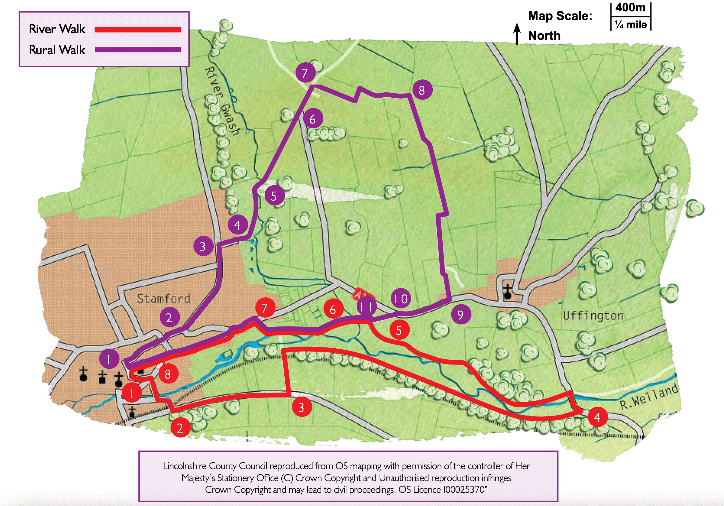
In 1967 Stamford became the first Conservation Area in the country. Today it is an attractive market town  and a great place from which to explore the local countryside.

You will walk beside the dried bed of Stamford Canal. During the Middle Ages the River Welland was navigable but by the 16th century it was impeded by a number of water mills. Work on the canal was completed during the 1660s at a cost of several thousand pounds. At the time it was the longest locked canal in the country and only the second post-Roman canal to be built. It ran for 6¾ miles from Stamford to just west of Market Deeping. The arrival of the railway to Stamford from 1846 led to the demise of the canal which was already in poor condition. The last barge travelled along the canal in 1863.

The Benedictine Priory of St Leonards was established around 1082 on the supposed site of an earlier monastery. The building is a fine example of Norman architecture and the grand west front was built in 1150. From the 14th century onwards there were few monks living there and after the dissolution it passed to the Cecils.

  • 1Leave the TIC, turn right into St George’s Square. Follow the road on the right of St George’s church, Blackfriars Street. At the junction cross the road ahead with care and continue straight ahead along Albert Road. Cross the river Welland and turn left.
  • 2At the T-junction with Barnack Road, and opposite an entrance to Burghley Park, turn left. Follow the roadside path for approximately 0.5 miles (one kilometre).
  • 3Turn left along a public right of way. Cross the railway line with care and then turn right along a public footpath which forms part of the Torpel Way, a route that links Stamford with Peterborough. This section of path is uneven in places and there may be rabbit holes, please take extra care. Follow the path for 1.25 miles (2 kilometres) and into an open field. Walk along the bank for 150m before bearing right off the bank to a kissing gate and road.
  • 4Turn left and cross the old stone bridge over the river Welland. Immediately after the bridge turn left along a public footpath.
  • 5After approximately one mile (1.5 kilometres) and at a kissing gate and bridge over the canal turn left. Walk alongside the fence to a bridge.
  • 6 Cross the bridge and continue straight ahead across the field to walk between the hedge and the river. Follow the path, keeping the hedge and wall on the right, to a gate. Follow the track straight on past Hudds Mill before bearing right to continue along the track and bridleway.
  • 7At the junction with a road turn left. At the roundabout bear left along Priory Road and past St Leonards Priory.
  • 8At the end of Priory Road carry straight on along St Leonards Street. As the road bends right, turn left along St Georges Street. Follow the road round to the right in front of St George’s Church to St Georges Square. Cross St Georges Square to return to the starting point.

The walk uses roadside pavements, countryside paths and field paths. You are likely to encounter stiles and livestock. A railway line is crossed once.

more information

Starting point

Tourist Information Centre (TIC) and Arts Centre

St Mary’s Street

Stamford

PE9 2DL

Grid reference TF 031 070