Walk
Loop
6.5miles
(10.46km)
3 hours

Walking

Boston River & Rail Long Walk

On this walk you will experience both town and country taking in some of the historic streets of Boston, crossing fertile fenland fields and walking beside both a river and a man-made drain.

During medieval times Boston was a prosperous town with a thriving port dependent on the river. During the 18th and 19th centuries improvements were made to the river and the channel to the sea to ensure continued use of the port. At the same time the fens were being drained and large areas of fertile farmland were being created. As well as controlling the level of water in the fens the drains are now also used for recreation, including fishing, walking, cycling and boating. The railway arrived in Boston in 1848 and the early 20th century was Boston’s largest employer. Today the railway links Boston with Grantham and Skegness and is a popular service, especially during the summer months when people travel from the Midlands to the Lincolnshire coast for their holiday. This is one in a series of walks in the Boston area. The others are: Boston: Town walk Boston: Waterways walk We hope you enjoy them.

Starting point and parking: The Guildhall, South Street, Boston, PE21 6HT. Grid reference TF 328 438

  • Linked to Public TransportLinked to Public Transport
  • RefreshmentsRefreshments
  • Dog FriendlyDog Friendly

There are a number of interesting buildings reflecting Boston’s history between The Haven and the Market Place. Look out for the 18th century Fydell House, The Guildhall (now a museum), the Custom House, the timber framed Shodfriars Hall and of course The Stump, St Botolph’s Church. For more information on these pick up a copy of the Boston Town walk.

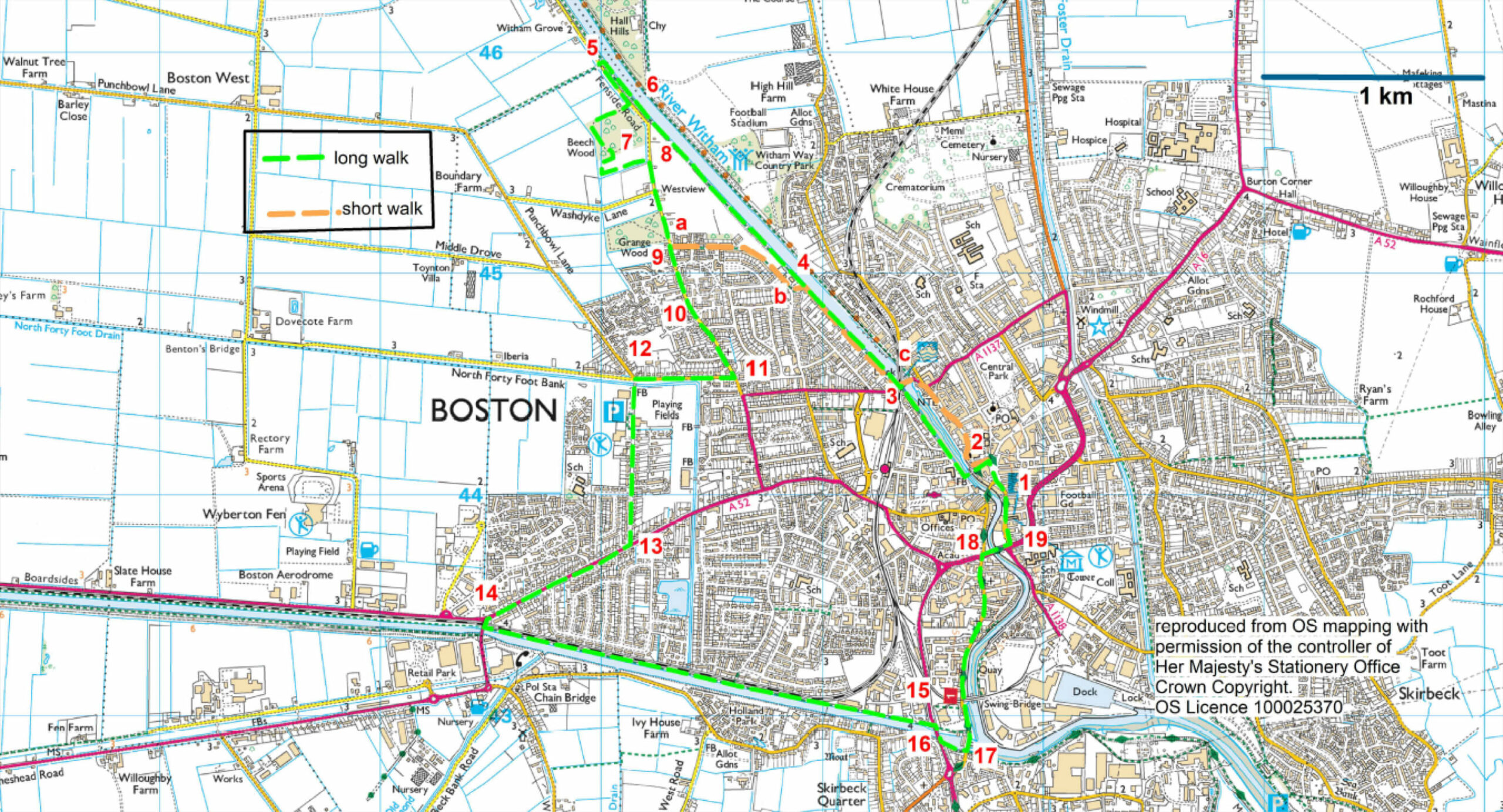
The Boston Woods Trust was formed in 2001 to provide the people of Boston with recreational opportunities such as walking and bird watching. So far 45 acres of trees have been planted in three woodlands:Beech Wood, Grange Wood and Westgate Wood.

In this arable landscape lookout for hares. If disturbed, this shy animal will flee at high speed – up to 35 miles an hour! Alternatively they may crouch low to the ground in the hope of being camouflaged from their predators such as owls, foxes and buzzards.

The South Forty Foot Drain was first dug in 1657 amid much opposition from local farmers who had grazing rights on the existing common land. Much of the work was destroyed by the graziers and it was not until 1756 that the drain was improved and reconstructed and the rights of common grazing were abolished and farmers rented or purchased land.

This section of railway line is part of The Poacher Line that links Grantham, Sleaford, Boston, Wainfleet and Skegness.

The Swing Bridge was built by Handysides, an iron foundry in Derby, in 1882 to connect the docks with the Great Northern Line across the Haven. The bridge was originally operated manually but was converted to electricity in 1981. The docks were opened in 1884.

London Road was once the main route into Boston from London and properties date from the 16th century and include Boston’s first bank. Look out for the terrace of tall houses on the right (numbers 124-136) which are known as The Barracks and thought to date from the late 17th or early 18th centuries.

  • 1Leave The Guildhall and turn right. Cross the Market Place and turn left along Church Lane (in front of the statue of Herbert Ingram near St Botolph's church).
  • 2Walk over the pedestrian bridge and turn immediately right. Follow the riverside path, signed to the marina.
  • 3At the Grand Sluice bridge turn left and cross the road and the railway line, and then turn right along Witham Bank West to continue alongside the river and past the marina.
  • 4At the Rowing Club continue straight on along the path beside the river. After approximately 0.9 miles (1.4 kilometres) leave the river bank along a footpath, down a slope to a road.
  • 5Turn left along the road. At the far end of the car park turn right into Beech Wood taking the right-hand path.
  • 6Follow the surfaced path through the wood and around to the left past some wooden sculptures.
  • 7Where the path divides into two turn right and then right again and follow the path past a pond and then on to another car park and road.
  • 8Turn right and walk along the road, past Grange Wood, another Boston Woods Trust woodland. You can take a detour around the wood.
  • 9At the first small roundabout continue straight on.
  • 10At the second roundabout again continue straight on.
  • 11Turn right along Langrick Road, signed Coningsby.
  • 12After 450 metres turn left across the bridge and over the North Forty Foot Drain and follow this road past sports grounds to its junction with the A52.
  • 13Use the pedestrian crossing to cross the A52 and then turn right.
  • 14At the roundabout turn left over the level crossing. Immediately after the crossing and before the drain turn left along the public footpath. Follow this path beside the South Forty Foot Drain. After crossing a pedestrian bridge continue along the path to a junction with a road.
  • 15Turn right, and follow the road to a junction with the busy A16.
  • 16Turn right and cross the drain and then use the pedestrian crossing to cross the road and then continue straight ahead alongside the drain and towards the Black Sluice.
  • 17At the junction with a road turn left along London Road, which becomes the High Street. Walk past the Swing Bridge, and over the level crossing to a junction with the A16. A distance of 900 metres (0.5 mile)
  • 18Cross the A16 at the pedestrian crossing. Turn right and cross the High Street and then the river.
  • 19Turn left along South Street to return to the starting point.

 This walk uses roadside pavements, field paths and quiet roads. There are no stiles and you are unlikely to encounter livestock.

more information

Starting point and parking: The Guildhall, South Street, Boston, PE21 6HT. Grid reference TF 328 438