Walk
Loop
5miles
(8.05km)
2 hours
30 mins

Walking

Fishtoft Walk

Fishtoft

This walk is set in the low lying fens between the village of Fishtoft and The Haven, close to Boston.

Throughout the walk it is easy to see man’s influence on the landscape, as it passes drains, a pumping station and the straightened channel of The Haven.

The 83m (272 ft) tall octagonal tower of St Botolph’s church in Boston is known as the Boston Stump and is the tallest tower of any English parish church. It is a landmark which is visible for miles in the surrounding fens, and in years gone by was used as a navigation marker.

Mentioned in the Domesday Book the village of Fishtoft was referred to as Toft, meaning hill or high ground. The village sits on a small area of glacial clays within an area of alluvial sediments originally giving it a dry foothold overlooking The Wash. A creek once flowed from near the church towards what is now the Hobhole Sluice, and many villagers were fishermen. This may explain the name Fishtoft.

Recent archaeological excavations have uncovered a wealth of Saxon finds which are rare in the Lincolnshire Fens. Alongside pottery and animal bone more unusual finds include a complete lead ingot and evidence of saltmaking during the Anglo-Saxon period.

Starting point: Starting point: St Guthlac Church, Clampgate Road, Fishtoft, PE21 0RZ
Grid reference: TF 363 425

  • ParkingParking
  • Linked to Public TransportLinked to Public Transport
  • RefreshmentsRefreshments
  • Dog FriendlyDog Friendly

The church is dedicated to St Guthlac, the patron saint of the Fens and founder of Crowland Abbey. He can be seen in the lancet window of the chancel and a small statue can be seen on the west face of the tower. The church sits on the highest ground in the village.

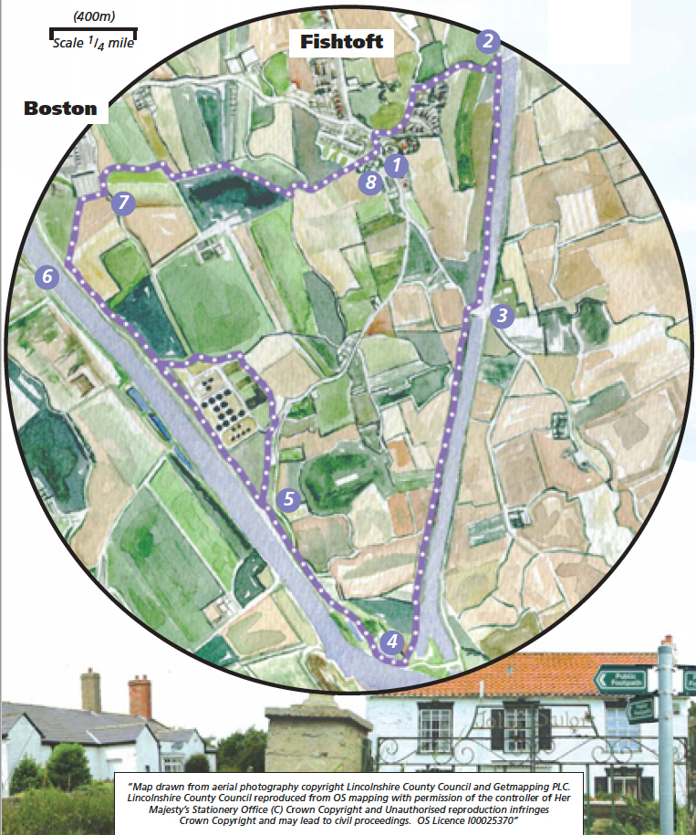
Between points 2 and 4 you will walk alongside the Hobhole drain. This man-made drain carries water from fenland north of Boston. It was designed by John Rennie and built between 1802 and 1812. It is 14 miles long and originally the water flowed by gravity but in 1867 a pumping station had to be erected at Lade Bank.

The Hobhole drain ends at point 4 where it reaches the Hobhole pumping station. The pumping station, built in 1957, now maintains the level of water in the drains to ensure the fertile fenland fields do not flood.

The Pilgrim Fathers memorial was erected in 1957 and marks the place where a group of puritans, from Scrooby, in Nottinghamshire, and from Gainsborough, were arrested attempting to flee to religious freedom in 1607. Some of them were tried and imprisoned in the Guidhall at Boston. They eventually made it to Holland in 1608 and then in 1620 sailed to the New World, via Plymouth, in the Mayflower and became known as the Pilgrim Fathers

The Haven is the stretch of the river Witham downstream of the Grand Sluice. The channel itself
meandered and often became silted up making the port of Boston almost unusable. In 1800, engineer John Rennie was commissioned to survey the river and recommend improvements. By 1884 work on the scheme was complete and the length of the channel shortened by 41/2 miles. The first ship to sail up the new channel and into the dock was The Myrtle with a cargo of cotton seed.

As you walk across arable fields look out for hares. They have long blacktipped ears, large staring eyes and long powerful hind legs. They can avoid most predators by running at up to 56 km (35 miles)per hour.

  • 1With your back to the church gate, turn right and follow the road to the right for approximately 500m to Clampgate Bridge, which spans the Hobhole Drain.
  • 2Turn right onto the footpath just before the bridge to follow the west bank of the drain. Follow the path for approx. 0.75 miles (1.2 kilometres), to join the road.
  • 3Cross the road and continue in the same direction along a footpath on top of the bank to open fields. Continue ahead along the field edge to emerge at the side of the drain. The building ahead and to the left is the Hobhole Pumping Station. Continue straight along the path, beside the drain, to a stone track.
  • 4Turn right towards a row of old coastguard cottages on the right, and then almost immediately left along a public footpath to the banks of The Haven. Turn right along the bank and past the Jolly Sailor (once a public house) and Horizons art installation, to the Pilgrim Fathers Memorial. Continue along the river bank and walk through the small car park. Follow the path alongside the river heading towards Boston. The Boston Stump now being in full view.
  • 5Continue straight on beside the river, past the sewage works.
  • 6600m after the sewage works you will reach Corporation point, and the path splits into two. Take the right-hand path away from the river heading towards the large warehouse. Keep right and at a junction of signed paths turn right down some steps, over a bridge and alongside the warehouse to a road.
  • 7Turn left and then right along a public footpath which runs along the field edge and beside a ditch. Follow the path beside the ditch as it winds its way across the field heading for Fishtoft village. Where the ditch meets a larger drain turn left and follow the path beside the drain (with the drain on your right).
  • 8The path will eventually pass some allotments and houses to join a tarmac drive to the village. Turn left at the road and then right at the junction to return to the starting point.

This walk uses field paths, tracks, river banks and quiet roads. There are no stiles but you may encounter livestock.

more information

Starting point: St Guthlac Church, Clampgate Road, Fishtoft, PE21 0RZ

Grid reference: TF 363 425