(6.04km)
Boston is a town full of history and interesting buildings and it is well worth spending time exploring some of the quieter areas away from the town centre. In medieval times Boston was a thriving port exporting wool, lead and salt and importing cloth, wine, furs, leather and spices. At one time Boston paid more in custom duties than London. Some of the original medieval street pattern still remains and the streets east of the Market Place are good examples.
Trade declined in the 16th century because of the silting up of the river and the decline in the wool industry. The 18th century saw an increase in prosperity when the river was straightened, a sluice constructed and land west of Boston was drained and enclosed and started producing crops and supporting livestock. Growth continued in the 19th century and The Haven, the channel to the sea, was straightened and the docks opened. This walk will take you beside the river and one of the manmade drains, through a town park and old cemetery where wildlife is encouraged, and past a windmill, Masonic Hall and footbridge that is designated a Scheduled Ancient Monument.
This is one in a series of walks in the Boston area. The others are: Boston: River and Rail walk Boston: Waterways walk. We hope you enjoy them.
Starting point and parking: Boston Guildhall and Tourist Information Centre, South Street, Boston, PE21 6HT, Grid reference TF 328 438.
Dogs not permitted in Boston cemetery.
To check cemetery opening times go to www.boston.gov.uk
Linked to Public Transport
Refreshments
Town Bridge was built in 1913 to replace the cast iron arch bridge built by Sir John Rennie in 1805. Rennie also designed London’s Waterloo Bridge.
The Grand Sluice was constructed across the river Witham in 1766 after years of decline in the town’s prosperity.The sluice regulated the tides and prevented the river from silting up.
The Centenary Church was opened in 1911 and replaced a previous chapel which had to be demolished after a fire in 1909.
Central Park was purchased by the corporation in 1919 and opened in 1932 and is now a popular green space close to the centre of the town.
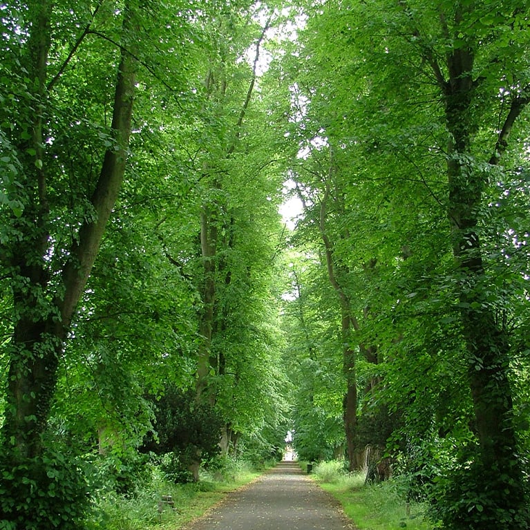
The Boston burial board purchased 12 acres north of the town in 1854 and advertised a competition for the design of two chapels, a lodge, entrance gates and a layout for a cemetery including planting. The cemetery and chapels (Anglican and Nonconformist) opened on 15 October 1855. The Anglican chapel still stands, south of the road, but the identical Nonconformist chapel to the north of the road was demolished in 1961. The area is now managed for wildlife and the variety of mature trees makes it a great place for birds. The majestic avenue of lime trees dates back to the original layout.
The Hospital Lane footbridge was built in 1811 as the stamp on the supporting girder states “Cast at Butterley 1811”. The bridge is a Scheduled Ancient Monument. The mill was built in 1819 for Thomas and Isaac Reckitt by Hull millwrights Norman and Smithson at a cost of £1826. Following a number of poor harvests the business failed in 1833 and the mill was sold. The windmill worked again between 1914 and 1948 and then until the late 1950s using electricity to power the equipment. The present owners bought the mill in 1987 and have brought it back into working order.
The Masonic Hall was built between 1860 and 1863 as a replica of the Temple of Dandour in Nubia. The columns are carved with hieroglyphics, and leaves around the base.
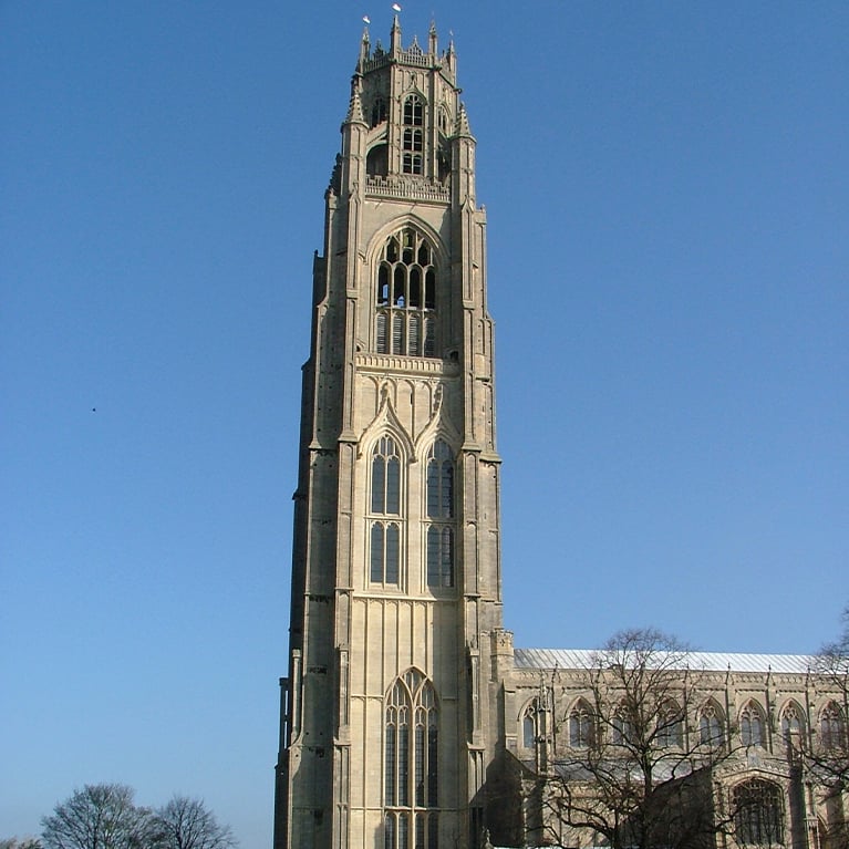
The church of St Botolph dominates the Market Place. Also known locally as The Stump, it is a giant amongst parish churches, reflecting the town’s prosperity at the time it was built. The tower is 272 feet high and is a landmark visible for miles across the surrounding fenland. Construction started in 1309 and all but the tower was complete by 1390. The tower was built between 1425 and 1520. The statue in the Market Place is of Herbert Ingram (1811 – 1860) who was a Boston MP, founder of the Illustrated London News and responsible for bringing piped water to the town.
The Assembly Rooms opened in 1822 as part of a refurbishment of the Market Place. Built in 1772 the Exchange Buildings, formerly Corporation Buildings, was used as the Town Hall, Courtroom as well as providing residential accommodation for local people.
Shodfriars Hall, the timber framed building on the left, was built in the 15th century and restored in 1874 when a hall at the rear was built and used as a theatre. A few doors down is the Custom House, erected on the site of the former Dominican Friary.
Originally the refectory range of the Dominican Friary from the 13th century. The friars were known as shodfriars because rather than go barefoot they wore sandals. The building was bought by Boston Preservation Trust in the 1930s. They built a theatre and then sold it in the 1980s to the Blackfriars Arts Centre.
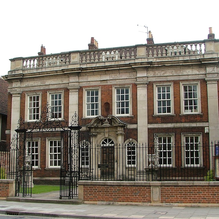
The next building of note is The Guildhall which became a museum in 1929. It was built in 1450 and was occupied by the religious guild of St Mary until all its assets were handed over to the corporation in 1545. The building was then used as a town hall, banqueting hall, council chamber, courtroom and cells. It was here that some of the Pilgrim Fathers were held before leaving the country on the Mayflower. The building and museum have recently been renovated. Next door is Fydell House, described as the grandest house in town. It was built in 1726 in red brick in Flemish bond. It was owned by the Jackson family before becoming the home of Joseph Fydell, Mayor of Boston. It was owned by the Fydell family, some of whom were MPs for Boston. The Boston Preservation Trust bought the house in 1935 and it is now a venue for meetings, marriages and courses.
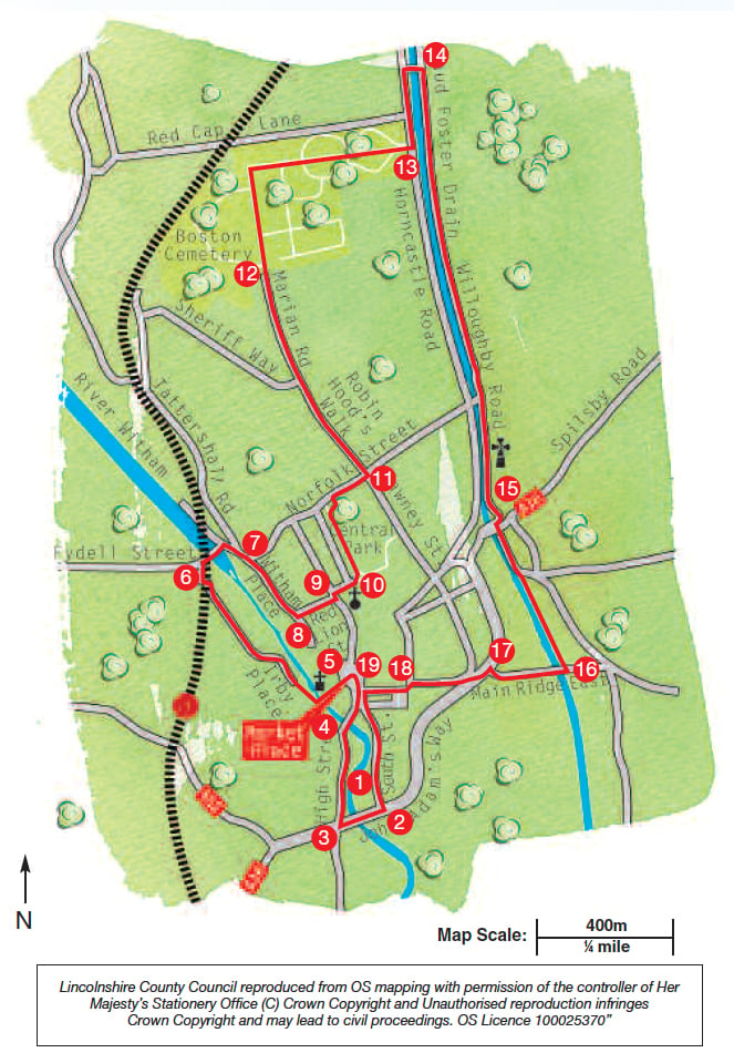
- 1Leave The Guildhall and turn left.
- 2At the traffic lights turn right and cross the river over Haven Bridge.
- 3Turn immediately right along the High Street. Follow this road to cross the river again using Town Bridge and enter the Market Place.
- 4Turn immediately left onto Fish Hill and walk in front of the Assembly Rooms and straight on along Church Street.
- 5At the junction with Church Lane turn left and cross the pedestrian bridge over the river. Turn immediately right (signed Marina) to walk beside the river for approximately 500m.
- 6At the junction with the main road turn right and cross the river at Boston Lock and the Grand Sluice. Follow the road as it bends to the right along Tattershall Road.
- 7At the traffic lights continue straight ahead along Witham Place for approximately 200m.
- 8Turn left along Red Lion Street.
- 9At the crossroads walk straight ahead along Norman Avenue and past the Centenary Methodist church. At the corner enter Central Park.
- 10Turn left and follow the path around the edge of the park. At the far end of the park leave by the gates, turn right.
- 11At the traffic lights turn left, cross the road and walk along Robin Hood’s Walk. Continue straight on as it becomes Marian Road.
- 12Enter the cemetery (no dogs allowed) and walk straight on along the road. Carry straight on at the mini roundabout. Follow the road as it bends to the right past a small cemetery chapel and war memorial. Enter the older part of the cemetery and look out for another old chapel on your right. Leave the cemetery at the gatehouse.
- 13Turn left and then right across the footbridge over the Maud Foster drain. Turn right and follow the drain towards Boston town centre.
- 14Walk past Hospital Lane footbridge and Maud Foster windmill.
- 15At the traffic lights turn right and cross the main road (A16) at the pedestrian crossing. Walk straight ahead to continue walking alongside the drain for approximately 430m.
- 16At the next bridge, Vauxhall Bridge, turn right over the drain.
- 17At the traffic lights turn left and cross the road, and then cross the main road (A16) at the pedestrian crossing. Walk straight ahead through the gap in the wall. Turn left, along Main Ridge West. Look out for the Masonic Hall on the left.
- 18At the end of the road turn left to enter Pump Square. Turn immediately right to walk along the edge of the square and walk straight on along Dolphin Lane to the Market Place.
- 19Turn left and walk along South Street. Take a few minutes to admire the range of buildings in the Market Place including the Assembly Rooms and Exchange Buildings. There are several notable buildings along South Street A short detour down Spain Lane will take you to Blackfriars Art Centre. Return to South Street and turn left to continue the walk and return to the starting point.
This walk uses roadside pavements and roads through the cemetery. There are no stiles or livestock.
nearby walking routes
more information
Boston Guildhall and Tourist Information Centre, South Street, Boston, PE21 6HT, Grid reference TF 328 438.
