Walk
Loop
12miles
(19.31km)
6 hours

Walking

Boston Waterways Walk

The waterways, both the river Witham and the man-made drains, have played an important role in the prosperity, and at times decline, of Boston throughout history.

A thriving port during the medieval period, and at times rivalling London in the amount of custom duties collected, the town went into decline when the river silted up preventing ships reaching the port. During the 18th century the construction of the Grand Sluice and the straightening of the river helped reduce the silting and during the 19th century the channel between the docks and The Wash, known as The Haven was straightened. The drainage of the fens and the construction of sea banks over the centuries have created large areas of fertile land suitable for growing crops and increasing local prosperity.

The extensive waterways network also provides an important wildlife habitat and as you follow this walk you are likely to see a variety of plants and animals, at all times of year. Some of the waterways are now being developed for recreation and tourism with new angling facilities, moorings, cycle routes and navigable stretches of water. This is one in a series of walks in the Boston area. The others are: Boston: River and Rail walk Boston: Town walk We hope you enjoy them

Starting point: The Guildhall, South Street, Boston, PE21 6HT. Grid reference TF 328 438

  • ParkingParking
  • Linked to Public TransportLinked to Public Transport
  • RefreshmentsRefreshments
  • Dog FriendlyDog Friendly

Look out on the left for the remains of Hussey Tower, a red brick building dating from 1489 and all that remains of Hussey Hall. The Hall belonged to Lord Hussey, a leading nobleman in the county, who was tried and hanged in 1537 for high treason after he failed to suppress the Lincolnshire Rising the previous year.

The parish church of St Nicholas is thought to predate St Botolph’s church in the centre of Boston and is mentioned in the Domesday Book.

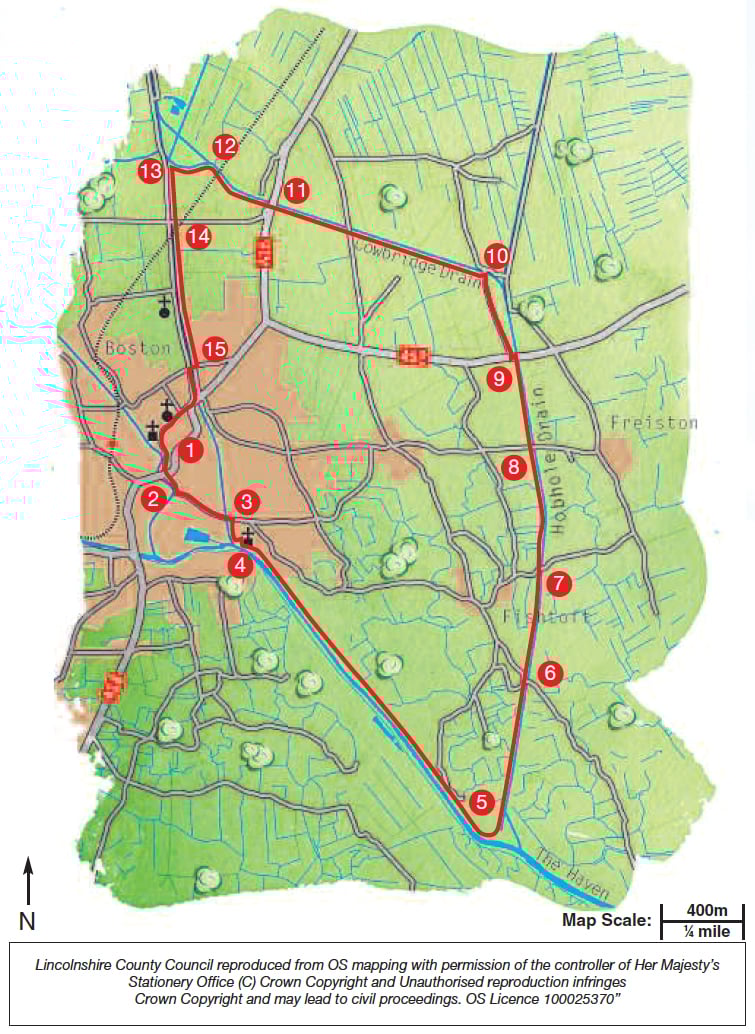
The Haven is the section of the River Witham downstream of the Grand Sluice in Boston. In the 18th century it meandered out to The Wash and often silted up preventing shipping using Boston Docks. In 1800 the engineer John Rennie was commissioned to survey the river and recommend improvements. By 1884 The Haven had been straightened and shortened by 4½ miles!

Havenside Local Nature Reserve (LNR) consists of a variety of habitats including rough grassland, scrub, meadow, ponds and mudflats. Look out for the black and white oystercatcher feeding on the edge of the river, as well as the colourful goldfinch and yellowhammer amongst the scrub and grass.

The Pilgrim Fathers’ Memorial was erected in 1957 and marks the place where a group of puritans were arrested attempting to flee to religious freedom in 1609. Some were tried and imprisoned in the Guildhall in Boston, which is now a museum. Look out for the remains of a number of Second World War pill boxes and gun houses along The Haven banks.

  • 1Leave the Guildhall and turn left.
  • 2At the traffic lights and crossroads continue straight ahead along South End. After 250 metres turn left along Skirbeck Road.
  • 3Cross the Maud Foster Drain and turn right along Windsor Bank.
  • 4Climb onto the bank next to the sluice and turn left along the road. After approximately 30 metres bear left off the road to follow the path beside the pond. Turn right in front of the church along the public footpath. Cross the road and continue along the bank beside The Haven. Continue to walk along the bank of The Haven, through Havenside Local Nature Reserve (LNR), past the sewage works and to the Pilgrim Fathers memorial, in total approximately two miles.
  • 5Continue along the river bank and walk past the Jolly Sailor. Turn left to join a lane. Turn right and then left along a public footpath beside the Hobhole Drain. Follow the path alongside the drain and through the nature reserve to a road.
  • 6Cross the road and continue along the public footpath beside the drain.
  • 7At the next road, continue straight on again.
  • 8At the next road junction continue straight on again alongside the drain.
  • 9The next road you come to is the busy A52. Cross the road with care, turn left and then right along Bakers Lane.
  • 10After approximately 1000m, and just before a bridge, turn left along the public footpath beside Cowbridge Drain. At the junction with a road continue straight on beside the drain.
  • 11The next junction is with the busy A16 road. Cross the road with care and continue straight on along the public footpath. Cross the railway line with care and continue straight on for approximately 150m to a junction of paths.
  • 12Take the left hand path.
  • 13Before reaching the road and in front of the house, turn left following the public bridleway along a track
  • 14At the road continue straight on beside the Maud Foster Drain. Cross the railway line with care.
  • 15Turn right at the junction with Hospital Lane to cross the drain using Hospital Bridge. Turn left along Horncastle Road. At the junction continue straight on along Wide Bargate and into the town centre and onto Bargate and Market Place. Continue straight on through the Market Place and onto South Street to return to the starting point.

This walk uses roadside pavements, field paths, tracks and quiet roads. There are no stiles. You may encounter livestock.

more information

Starting point: The Guildhall, South Street, Boston, PE21 6HT. Grid reference TF 328 438