


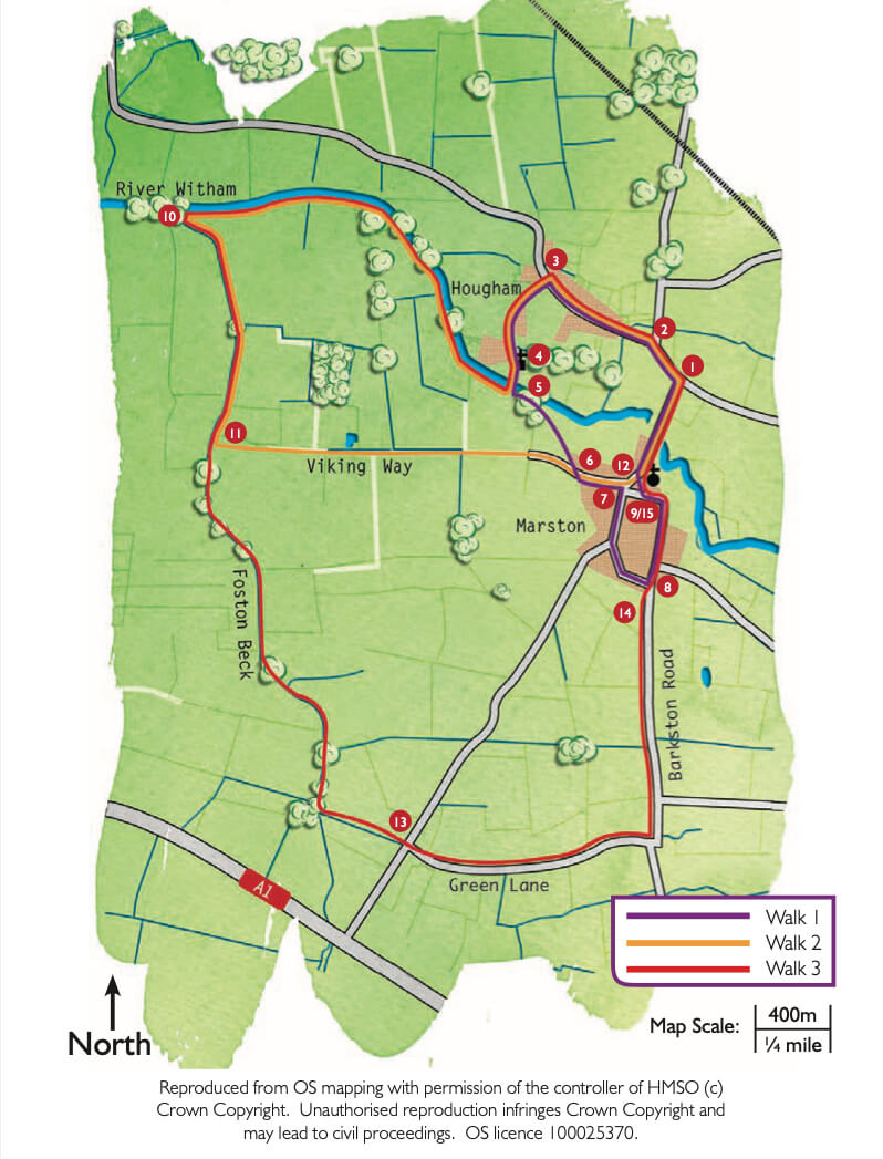
- 1Leave the village hall car park and turn right along the main road.
- 2After approximately 200m turn left to Hougham.
- 3In Hougham village take the second left, Coach Road, and follow it to the church.
- 4Follow the footpath through the churchyard and across the field corner to the footbridge and weir over the river Witham. Hougham Manor can be seen on your left. Go over the bridge, across the paddock, through the hedge, and over the bridge.
- 5On the other side of the bridge turn right along a footpath alongside the ditch. At the junction with a bridleway turn right and follow the field edge to the river. Follow the river bank for about 1.5 miles (2.5 kilometres) to where the river is joined by the Foston Beck.
- 10Turn left and follow the Foston Beck for about 0.75 miles (1.2 kilometres) to where it meets the Viking Way.
- 11Continue straight on beside Foston Beck. Ignore the bridge over the beck which takes the Viking Way towards Foston, a footpath over the beck and also, further along, ignore a sign for a bridleway to the left. Continue to follow the beck and bridleway. Walk between the beck and solar farm before turning left at the end of the solar farm, to the junction of Toll Bar Road and Green Lane.
- 13Cross over into Green Lane and after about 100m, and just before the bend, step into the field on your left and follow the bridleway which runs alongside Green Lane but on the other side of the ditch or hedge. Continue along the bridleway beside the road for approx. 1.5 miles (2.5 kilometres). This leads right to the edge of Marston village where the fields end.
- 14At the edge of Marston village step out onto Barkston Road and follow the road through the village to the sharp left-hand corner where the road becomes School Lane. The entrance to Marston Hall is on this corner. Follow School Lane as far as the end of the Hall’s garden (the end of the stone wall).
- 15Turn right into a narrow footpath leading to the church. However, before doing this go a little further down School Lane to view the school itself on your left (and possibly visit the Thorold Arms on your right), then return to the footpath. At the end of the footpath turn left and follow the village green to Bridge Street and turn right back to the village hall (about 0.3 miles/ about 500m).