 Linked to Public Transport
 Refreshments
- Dog Friendly
Things to look out for
Tick off the landmarks and points of interest you spot along this route as you go.

Long Benington – A1
Also known as the Great North Road, it is the longest numbered road in the UK, at 410 miles (660 km). It connects London with Edinburgh. Its importance was recognised when it became Britain’s first numbered road in 1921


Sewstern Lane
An ancient route also known as The Drift which in places forms the border between Lincolnshire and Leicestershire. The development of the Great North Road and turnpikes reduced its importance, but the route was then used by cattle drovers, taking their herds down to the London market.


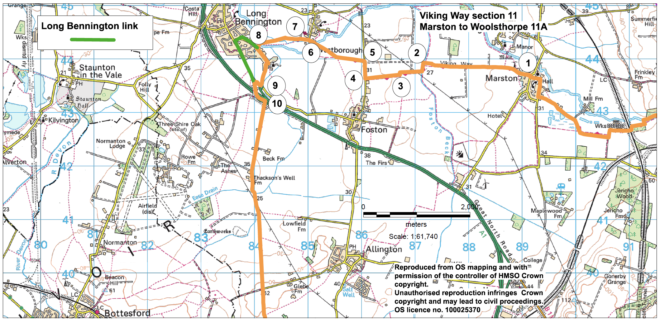
- 1Follow Stonepit Lane straight ahead for approximately 1.3 miles (two kilometres) to its end at a junction with another bridleway.
- 2Turn left and after approximately 150 metres turn right over the bridge and continue straight ahead along the bridleway for approximately 450 metres to a junction with a restricted byway.
- 3Turn right to continue along the bridleway to a road.
- 4Turn right and follow the road for approximately 300 metres.
- 5Turn left onto a bridleway. At the end of the hedged section continue straight ahead for approx. 300m to a junction with a footpath and bear right to join the footpath towards Westborough village. Cross the River Witham and continue ahead past the church to a road junction.
- 6Cross the road and continue straight ahead onto a public footpath. Walk straight across the field to a gate, bridge and junction with a bridleway.
- 7Continue straight ahead across the field. Follow the bridleway along the field edge and across two fields, the second being dedicated Denver's Field, to the river. Cross the river and follow the path to a road.
- (To visit Long Bennington village and its facilities : At point 8. turn right and at the T-junction turn left to join the main village road. For shops, pubs and café turn right. To return to the Viking Way turn left and follow the roadside path for approximately 0.5 miles (800 metres) to where the road splits into two. Take the right hand fork signed Sewstern Lane, taking care crossing and walking beside the roads. Join directions at point 10)
- 8Turn left and follow the road, as it bends right, for 0.5 miles (800 metres) to a roundabout.
- 9Turn right and then take the first left.
- Cross the A1 and follow the road, with care, as it bends to the left.
- 10Take the second turn on the right, Sewstern Lane. Follow the tarmac lane to its end and then continue straight on through the farmyard and along a stone track, still Sewstern Lane. Continue straight on for approximately 2.5 miles (four kilometres) to a level crossing. Cross with care, adhering to on site instructions.
- (To visit Allington village take the second footpath on the left after leaving the farmyard and follow it along the field edge and then between hedges to join a road. Turn left and follow the road into the centre of the village. To return to the Viking Way retrace your route along the same road (Bottesford Lane) but rather than turn onto the restricted byway, continue along the lane for approx 0.6 miles (one kilometre) to a junction with a stone track. Turn left and you are on the Viking Way.) Having crossed the A52 continue straight ahead along the lane and follow it as it bends to the left and enters a woodland. Follow the track for approx. another 0.6 miles (one kilometre) to a road.
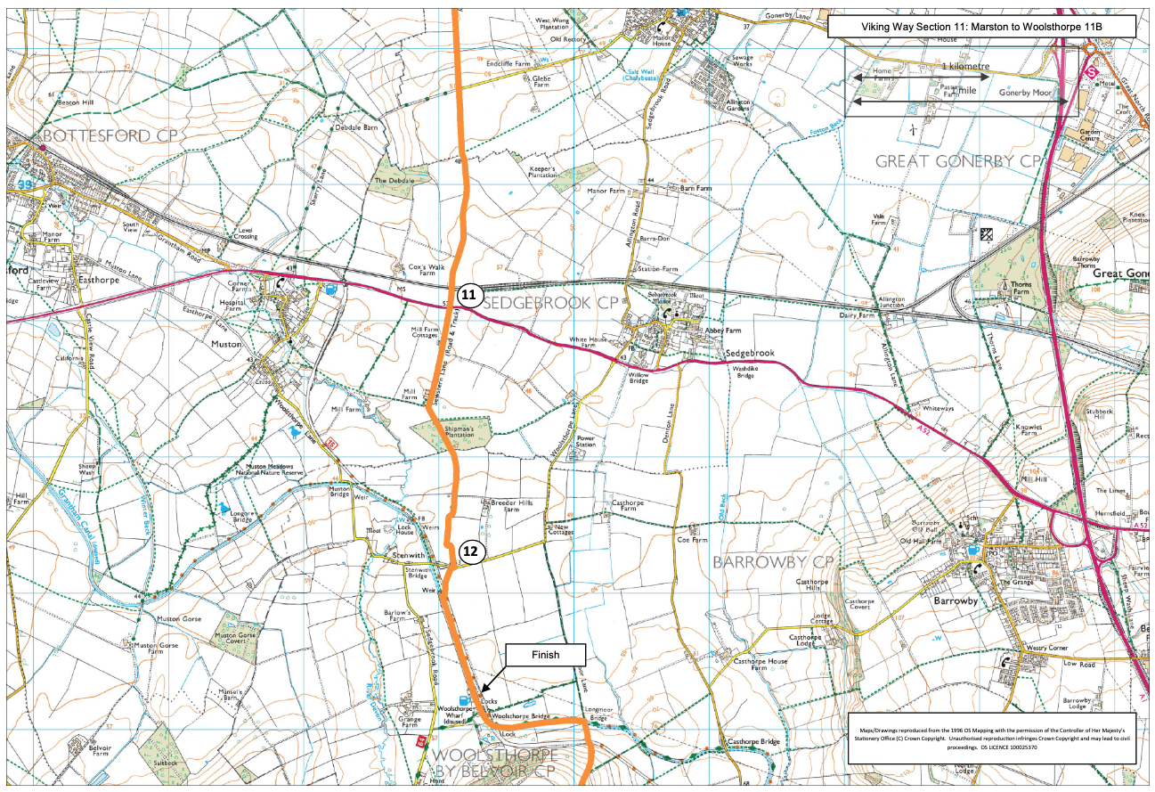
- 11Cross the busy A52 with extreme care.
- 12Cross the road and continue ahead along the track. After approximately 200 metres bear right to join the towpath beside the Grantham Canal. Keep on the towpath to The Duck pub beside the canal.