Walk
Loop
5miles
(8.05km)
2 hours
30 mins

Walking

Marston Walk Two

Marston

A walk between Marston & Hougham including a section on the Viking Way.

Starting point
Hougham and Marston Village Hall
Grantham
NG32 2JA
Grid reference: SK 894 441

  • Linked to Public TransportLinked to Public Transport
  • RefreshmentsRefreshments
  • Dog FriendlyDog Friendly

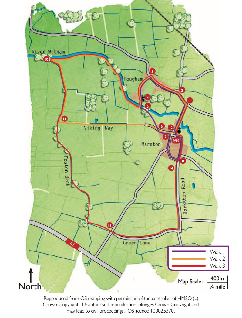
The villages of Marston and Hougham are situated six miles north of Grantham to the east of the A1, and are surrounded by agricultural land growing wheat, oil seed rape, carrots, potatoes, leeks and turf.  Wembley Stadium was turfed from this area.

Each village has its own church, but the village hall, playing field and various village societies are shared.  Marston is the larger village and has a pub, the ‘Thorold Arms’, and a primary school.  Both villages were mentioned in the Domesday Book of 1086.

The river Witham rises in South Witham, south of Grantham, and flows through Grantham and Lincoln before flowing into The Wash at Boston.  Look out for wildlife as you walk close to the river, including herons and swans.

The Viking Way is the long distance footpath through Lincolnshire.  Starting on the banks of the Humber and ending at Rutland Water it covers a distance of 147 miles.  The route is waymarked with a Viking helmet.


  • 1 Leave the village hall car park and turn right along the main road.
  • 2After approximately 200m turn left to Hougham.
  • 3In Hougham village take the second left, Coach Road, and follow it to the church.
  • 4Follow the footpath through the churchyard and across the field corner to the footbridge and weir over the river Witham. Hougham Manor can be seen on your left. Go over the bridge, across the paddock, through the hedge, and over the bridge.
  • 5Carry straight on, along the footpath, across the field towards Marston. This footpath linking the two villages is known as ‘The Beanholme’. On the other side of the bridge turn right along a footpath alongside the ditch. At the junction with a bridleway turn right and follow the field edge to the river. Follow the river bank for about 1.5 miles (2.5 kilometres) to where the river is joined by the Foston Beck.
  • 10Turn left and follow the Foston Beck for about 0.75 miles (1.2 kilometres) to where it meets the Viking Way.
  • 11Turn left and follow the Viking Way towards Marston - along the field edge, then a track and concrete road and into Marston on Stonepit Lane.
  • 12At the Thorold Arms public house turn left and follow Bridge Street back to the village hall (about 0.25 miles, 500m), passing the church on your right.

The walk uses roadside paths, quiet lanes and field paths. There are no stiles. You may encounter livestock.

more information

Starting point

Hougham and Marston Village Hall

Grantham

NG32 2JA

Grid reference: SK 894 441

more about the trail

Viking Way

The Viking Way is a long distance - 147 mile way-marked trail spanning from the River Humber through Lincoln to Oakham in Rutland. The route is signposted with an icon of a Viking helmet on a yellow disk.