Walk
Loop
5miles
(8.05km)
2 hours
30 mins

Walking

Foston Foston Circuit Walk

Foston

The village of Foston lies on an ancient crossroads, situated on the northern edge of the Vale of Belvoir, nearly six miles north-west of Grantham. Foston is traditionally a farming village with the River Witham running to the north of the village and the Foston Beck along the eastern border.

In Roman times there was a settlement in the parish and various pieces of Roman pottery, coins and other artefacts have been found in the area. Foston is most likely to have been founded in the late Anglo-Saxon period.

The Saxons settled in the district and extensive remains have been excavated on Loveden Hill, which can be seen to the east of the village. The name Foston comes from ‘Fot’s village’ from the Old Norse personal name Fotr and the Old English ton - village. Foston also appears in the 1086 Domesday Book as “Foztun”. In the early 19th Century, Foston had several Inns and Staging Houses due to its location on the Great North Road.

The Duke William public house was at the Allington crossroads, The Black Horse still exists in the centre of the village as a private house and flats, but The Black Boy was demolished in 1950, which stood at the Junction of Tow lane and Newark Hill. More recently, the Coopers Arms was demolished to make way for a residential property, situated on Newark Hill.

Starting point: St Peter’s Church, Long Street, Foston, NG32 2LD.

  • ParkingParking
  • Dog FriendlyDog Friendly

Additional Information

St Peter’s Church
St Peter’s Church dates back to the 12th Century and was substantially restored in 1858. It is a Grade I Listed Building with the chancel arch being one of the finest examples of late Norman buildings in Lincolnshire, having lines of beautiful clean cut chevrons decorating it. Look out for the unusual weather vane on top of the tower.

The Old Hall
The Old Hall is a Grade II Listed Building dating from 1647 as depicted on the worn date stone. The 17th and 18th century improvements and extensions to the hall use the typical masonry-work of their period, which can still be seen today.

The Great North Road
At the turn of the last Century when the Great North Road ran through the village, the vehicles on the road were mainly horse drawn. Travelling circuses would pass through the village along with occasional dancing bears and travellers from all walks of life

Devil’s Toenails
Keep your eyes peeled for these fossils which are abundant along the trail, suggesting that this area was once a shallow sea bed. They are related to oysters and the complete fossil consists of two articulated valves: a larger gnarly-shaped shell (the ‘toenail’) and a smaller, flattened shell, the ‘lid’. The soft parts from inside have long since disappeared

Ridge and Furrow
The final field on the left contains ridge and furrow, the remnants of medieval ploughing. The ridges are a result of ploughing with non-reversible ploughs on the same piece of land year after year.
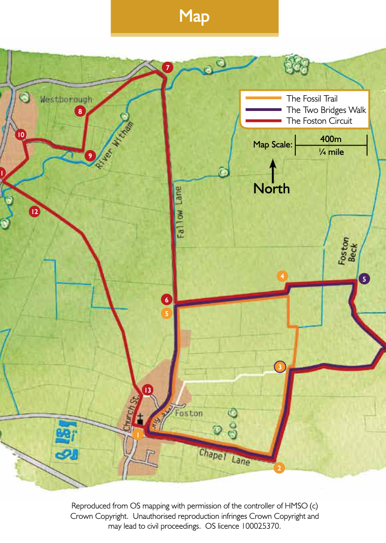
The Viking Way
This is a long distance footpath through Lincolnshire; starting on the banks of the Humber and ending at Rutland Water it covers a distance of 147 miles. The route is signposted with a Viking helmet

River Witham
The River Witham rises in South Witham and flows through both Grantham and Lincoln before entering The Wash at Boston. Look out for wildlife as you walk close to the river, including herons, kingfishers and swans.

Fallow Lane Ford
A concrete based ford with footbridge, allows access between Foston and Westborough through the River Witham. There are also the remnants of another ‘rough’ ford further down stream towards Westborough

All Saints’ Church, Westborough
Parts of the Church date back to the 11th Century with additions during the Middle Ages and restoration in 1811. Medieval settlement remains have been identified in the area close to the Church

  • 1Stand with your back to the Church notice board, turn right then immediately left into Chapel Lane. Follow Chapel Lane, past the Scout Hut (Gorrie Hall) and Village Playing Field and continue as it turns from road into track. This section of walk, to the junction with the restricted byway, uses a permissive footpath by kind permission of Baggaley Farms.
  • 2After approximately 550m past the Scout Hut turn left onto a restricted byway.
  • 3At the footpath junction turn right and follow the footpath down the middle of a field for 250m before bearing diagonally left to the first bridge over the Foston Beck.
  • 4Cross over the bridge and turn left.
  • 5The second bridge will appear on the left. Cross the bridge (which is part of the Viking Way) and continue straight ahead following the Viking Way for approximately 0.25 miles (400m), round to the left and then turn right at the signpost to continue on the bridleway and Viking Way.
  • 6As you emerge from the Viking Way onto Fallow Lane, turn right (not left back towards the village) and continue for about 0.75 miles (1.2 kilometres) to the River Witham. Cross the river via the footbridge then follow the track up to the footpath sign on the left.
  • 7Turn left onto the public footpath and walk across the field, towards a large willow tree in the hedge line. Cross the next field, by bearing diagonally left to the far left-hand corner of the field.
  • 8Cross the bridge in the corner of the next field and turn left onto a bridleway.
  • 9Follow the bridleway as it turns to the right and becomes Long Lane.
  • 10Where the lane bends to the right, turn left onto Back Lane (a grass track).
  • 11At the end of Back Lane turn left (away from Westborough Church) towards the river. Cross over the bridge then head diagonally left across the first field. This is clearly signposted as you are now back on the Viking Way.
  • 12Head straight across the second field, through a gap in the hedge and into field three. Foston Village is approximately 0.5 miles ahead of you. Carry straight on, neither turning left nor right, but heading towards Foston Church in the distance. Follow the footpath through the field boundaries, up a slight incline, keeping Foston Church in front of you.
  • 13After diagonally crossing the final small field, you re-enter Foston village on Church Street. Continue straight along Church Street to reach the Church on your left to finish the circuit.

This walk uses field paths, tracks and quiet roads. There are no stiles and you are unlikely to encounter livestock.

more information

Starting point: St Peter’s Church, Long Street, Foston

NG32 2LD

Grid reference: SK 858 429

more about the trail

Viking Way

The Viking Way is a long distance - 147 mile way-marked trail spanning from the River Humber through Lincoln to Oakham in Rutland. The route is signposted with an icon of a Viking helmet on a yellow disk.