


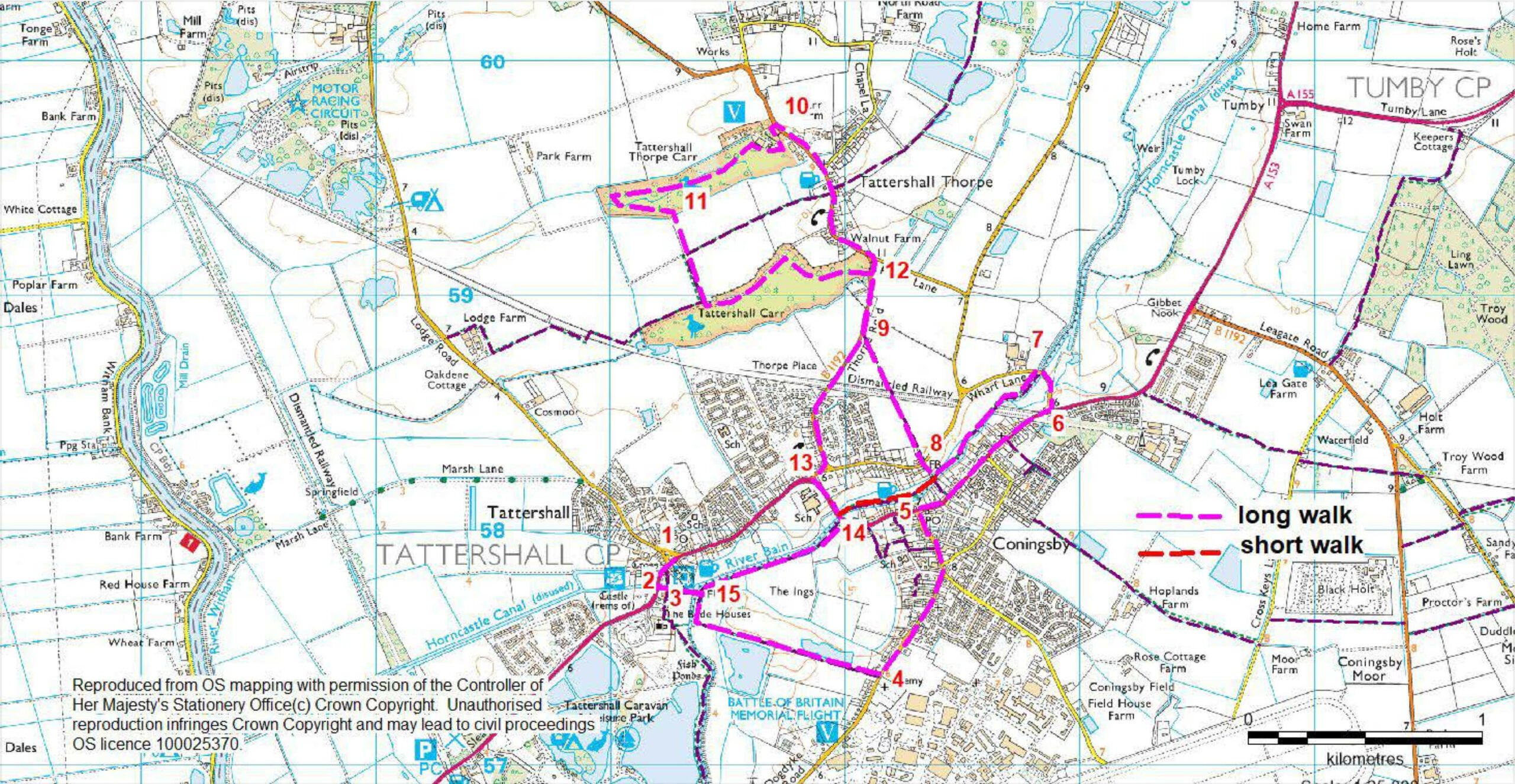
- 1Leave the Market Place and turn right towards the church and castle.
- 2After approximately 140 metres turn left onto a public footpath and follow it straight ahead beside the remains of the Horncastle Canal to a bridge over the River Bain at Tattershall sluice.
- 3Cross the river and turn right. Follow the river bank for approximately 150 metres before turning left and following a footpath, between two fishing lakes, to a road in Coningsby.
- 4Turn left and at the roundabout continue ahead along Silver Street into the centre of Coningsby.
- 5At the junction with the High Street turn right. Cross the road at the pedestrian crossing and continue in the same direction.
- 6After approximately 800 metres (0.5 miles) turn left along a lane signed to Tattershall Thorpe.
- 7Cross the river and then turn left along the footpath beside the river. Walk under the old railway bridge and continue along the river to a junction with a footpath and pedestrian bridge over the river.
- 8Turn right. Cross a road and continue straight on along a footpath. Cross the old railway line and walk across a field heading to the left of the houses in the distance.
- 9At the road turn right and walk along the roadside pavement for approximately one kilometre (0.6 mile).
- 10Turn left into the entrance of Thorpe Camp Visitor Centre. Before entering the Centre turn left through the gap in the fence and then through a gate into Tattershall Thorpe Carr (Woodland Trust). Follow the path to the right, along the fence line, through the woodland. Turn right over the bridge and follow the path around the edge of the woodland, crossing the ditch again at the other end of the wood.
- 11At a crossroads of paths (close to some brick structures) turn right through a gate to leave the woodland and follow the green lane towards another woodland, Tattershall Carr (Woodland Trust). Enter the woodland over the ditch and at a junction of paths turn left. Where the path forks take the left fork and follow the path around the edge and then across the wood to a path junction where there is a brick structure on the left. Turn left, behind some houses, to a road.
- 12Cross the road and turn right. Follow the roadside pavement for approximately one kilometre (0.6 mile) to a T-junction with the main road (A153).
- 13At the T- junction turn left.
- 14 Cross the river and turn right onto a footpath that runs along the river bank and follow the path to the bridge over the river.
- 15Cross the bridge and continue straight ahead to the road. Turn right to return to the Market Place.