


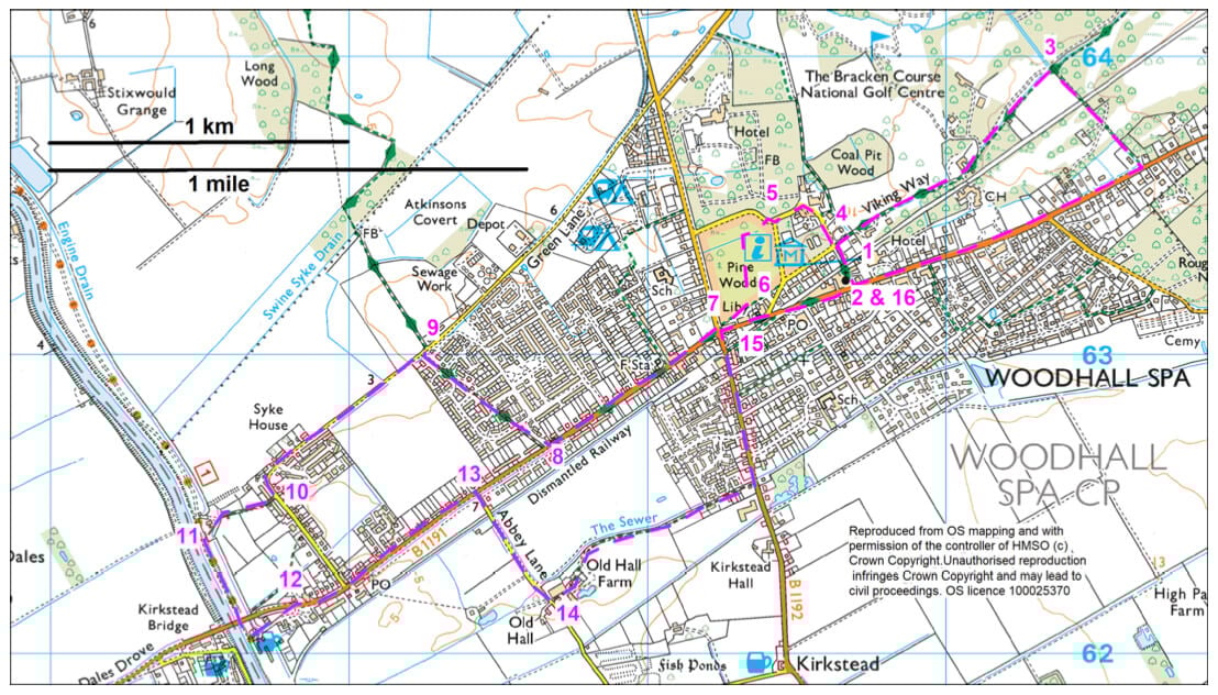
- 1With your back to the Cottage Museum entrance, turn left.
- The museum building is a rare corrugated iron bungalow that would have been supplied in kit form. It has stood on this site since 1887.
- 2At the crossroads turn left along the Broadway. Walk past the Golf Hotel and Woodhall Spa Golf Club before turning left onto a public footpath, a total of one kilometre (0.6 mile).
- The Golf Hotel was originally built as a house (Clevedon House) and later became a school and then a club before becoming a hotel. The westernmost part of the building is the oldest with the eastern end added in the 1920s.
- 3Cross the golf course and at the junction with another footpath, and Viking Way, turn left.
- Follow the path and then road straight on to a T-junction.
- Look out for the Manor House on your right. The red brick house is shown as The Lodge on the 1889 map, situated in substantial gardens enclosed by an attractive red brick wall. It was the home of the Hotchkins family who founded the Spa Baths.
- 4Turn right along Coronation Road, past the baths and Kinema in The Woods.
- The Spa Baths were built by the local squire, Thomas Hotchkin, on the site of a shaft that had originally been dug in 1821 in an attempt to find coal. By 1824 water had overflowed from the top of the abandoned shaft and between 1825 and 1829 this water gained a reputation locally as a healing cure. The complex has been greatly altered but some remnants survive. The Spa Baths and hotel complex began the development of the Woodhall Iodine Spa and eventually the settlement of Woodhall Spa itself.
- The baths were used to help the recuperation of soldiers suffering from nervous and mental fatigue after the first World War; this use continued after the second World War, when management of the baths passed to the National Health Service. The baths continued to be used to treat patients suffering from rheumatism until 1983, when the collapse of the well forced the building's closure.
- The Kinema is a cinema, converted in 1922 from a late 19th century pavilion, with later extensions. In Edwardian times it was used as a tennis and cricket pavilion for Petwood House. It is now a popular place to catch up with the latest movies.
- 5Just after the junction with King George Avenue bear left along a path into The Pinewoods.
- Follow the path as it winds its way through the wood. Take the second path on the left over a ditch and then straight on to reach the back of the town shops.
- In 1811, John Parkinson planted pine trees over an area known as Scrub Wood in order to produce pit props for his nearby coal mine which eventually flooded. The Pinewoods played a role in the second World War, as the area was used to hide vehicles and ammunition. You can still see concrete platforms and foundations of buildings dating from that time. The Pinewoods is now managed by the Woodland Trust. Look out for great spotted woodpeckers, tree creepers and maybe if you’re quiet a muntjac deer.
- 6Turn right to reach the road.
- 7Cross the road and walk straight on along Witham Road, and back on the Viking Way, for approximately 700 metres (0.4 mile).
- 8Immediately after Wentworth Way turn right onto a public footpath, still the Viking Way. Follow the path straight on, crossing two estate roads, to a junction with a lane.
- 9Turn left, leaving the Viking Way, and walk with care along the quiet road.
- Follow the road as it bends to the left. Follow it for another 65 metres.
- 10Turn right onto a track/bridleway and then field. Bear slightly right along the grass track. Go through the gate and bear left to a gate onto the riverbank and Water Rail Way.
- The River Witham and its tributaries provide an important land drainage and flood defence function whilst also being important for landscape and wildlife. The source of the Witham is south of Grantham and is fed by springs from the Lincolnshire Limestone. It supports populations of native crayfish and brown trout.
- The Water Rail Way is a flat, almost entirely traffic-free multi-user route linking Lincoln and Boston, a distance of approximately 33 miles. Cyclists and walkers can enjoy wonderful views of the fens landscapes from viewing platforms over the banks of the River Witham. The route follows the former Lincoln to Boston Railway Line. The route is dotted with sculptures from local artists.
- 11Turn left and follow the Water Rail Way under Kirkstead Bridge and then to the left in front of the old Woodhall Junction station house and follow the road to a T-junction.
- A former railway station and stationmaster's house, now house, dating from 1847 which underwent alterations in the 20th century. It was constructed of red brick with yellow brick dressings. The railway followed the banks for the River Witham and now forms part of the Water Rail Way.
- 12Turn right and walk along the pavement for approximately 700 metres (0.4 mile).
- 13Turn right onto Abbey Lane and follow it for 450 metres (0.3 mile).
- 14Turn left onto public footpath and follow it beside the ditch and then along a driveway to a road and turn left.
- 15At the roundabout turn right along Station Road and then The Broadway to the junction with Iddesleigh Road.
- The Royal Square Gardens, at the junction, were created on the site of the Royal Hotel which was destroyed during the second World War. The hotel was once the most imposing building in the town centre. It was built and owned by Adolphus Came, the architect who designed many of the buildings in the town. It was a grand building with a winter garden at its heart. The current gardens include the Dambusters Memorial and a stone commemorating the Royal Hotel.
- The Mall public house was once part of the Royal Hotel complex. It has an interesting porch with tree trunk columns which are also used internally. These columns are a rustic variation of the 'Arts and Crafts' style and are unique to Woodhall Spa.
- 16Turn left to return to the museum and the starting point.
- Sitting at the Junction Iddesleigh Road and The Broadway is Longwood House. It is one of the earliest private houses in the village. It has a large first-floor balcony, and the style is said to have been influenced by Napoleon's house on St Helena.