


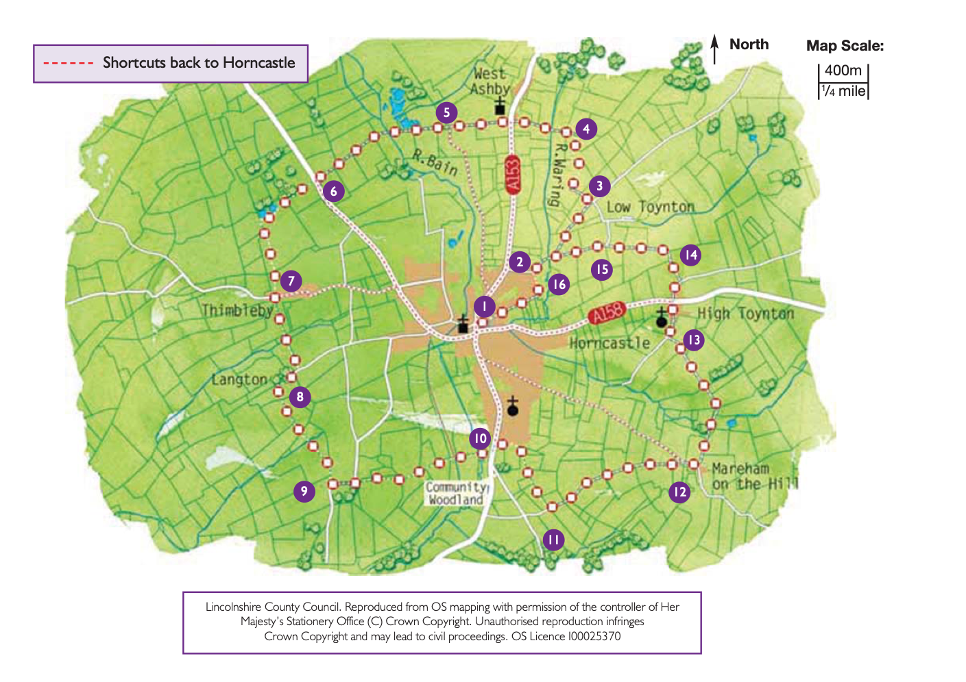
- 1With your back to the Post Office walk across the Market Place and turn left along High Street to its junction with North Street and Bull Ring. Cross the road and continue ahead along Banks Street. After approximately 200m turn left onto Linden Road and then almost immediately right. At the staggered crossroads walk ahead along Bowl Alley Lane. Walk past the schools and leave the road as it bends to the left to follow the grass track behind the houses. Continue along this path to a road.
- 2Turn right and walk along the road, taking the left fork towards Fulletby.
- 3At the next junction turn left onto the public bridleway. Follow the waymarks and Viking Way signs as the bridleway turns right, left and then right again before meeting another bridleway. In all approximately 2/3 mile (one kilometre).
- 4Turn left along the bridleway to West Ashby and the A153 road. (To return to Horncastle (1.5 miles, 2.5 kilometres) turn left and follow the roadside path.) Cross the A153 with care and continue straight ahead along the road signed to Edlington.
- 5Continue straight on to a staggered crossroads. (To return to Horncastle (1.5 miles, 2.5 kilometres) turn left and follow the road.) Carry straight on to the A158.
- 6(To return to Horncastle (1.5 miles, 2.5 kilometres) turn left and follow the roadside path.) Cross the busy road with care and follow the bridleway straight ahead, past a woodland to a junction with a public footpath. Turn left along the footpath past a small woodland and then across two fields. Walk past the bungalows to the road.
- 7(To return to Horncastle (1.5 miles, 2.5 kilometres) turn left and follow the roadside path.) Cross the road and walk along Chapel Lane. Ignore the tracks and follow the public footpath straight ahead across the fields to the left of the barn in the distance.
- 8At the road turn right into Langton. Walk past the church and take the footpath on the left just after Langton Manor Farm. Walk straight on along the field edge and then join a track and continue in the same direction. As the track bends to the left towards some trees continue straight on along the footpath to join another track. Follow the track to a lane. Turn left and follow the lane to a junction.
- 9Turn left, taking care along this busy road, into Thornton. Take the first road on the right. Cross the Horncastle canal to a T-junction with the A153. (To return to Horncastle (1.25 miles, two kilometres) follow the bridleway (Spa Trail) through the small car park just before the canal.)
- 10Turn left and after 200m take the public footpath on the right. (To return to Horncastle (1.5 kilometre, one mile) continue straight on along the roadside path.) The footpath turns immediately right and follows the fence line. Follow the fence line for approximately 0.25 mile (400 metres) to a corner where the fence goes off to the left. Walk straight on here across the open field to a fingerpost in the hedge line. Continue across the next field in the same direction past a reservoir to a road.
- 11Turn left and follow the road into Mareham on the Hill.
- 12At the junction in the village turn right. (To return to Horncastle (1.5 miles, 2.5 kilometres) turn left at the junction and follow the roadside path.) As the road bends right turn left onto a bridleway. Walk through the yard to the bottom left-hand corner and onto a hedged grass track. Follow the bridleway alongside the hedge, across the track by the houses to a bridge. Cross the bridge and bear right across the field to the corner and turn left to follow the bridleway along the track.
- 13At the junction with a lane, turn right into High Toynton, past the church to the junction with the A158. (To return to Horncastle (1.75 miles, 2.75 kilometres) turn left at the junction and follow the roadside path.) Cross the busy A158 with care and follow the road straight ahead signed to Salmonby.
- 14After 250m turn left onto a public bridleway. Follow it as it turns left onto a track. Leave the track as it bends to the right to follow the bridleway straight ahead alongside a hedge and into Low Toynton.
- 15At the road turn left and follow it into Horncastle.
- 16Just before you enter Horncastle, turn left along the public footpath behind the first houses. At the road turn left to a T-junction. Cross straight over and then turn left and then right into Banks Street to the High Street. Continue straight ahead to return to the Market Place.