


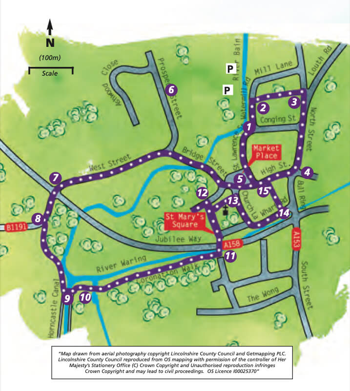
- 1At the Pagoda and bridge over the River Bain, follow Watermill Road alongside the river. This area is the north basin of the canal.
- 3Turn right along North Street. Cross Conging Street and continue past The Admiral Rodney Hotel and Old Nicks Tavern, formerly the New Inn, to the junction of North Street and High Street, the area known as the Bull Ring.
- 3Turn right along North Street. Cross Conging Street and continue past The Admiral Rodney Hotel and Old Nicks Tavern, formerly the New Inn, to the junction of North Street and High Street, the area known as the Bull Ring.
- 4Turn right onto the High Street and walk to the Market Place. Enter the Market Place.
- 5Continue to walk in the same direction and cross the Market Place and follow the road to the right, Bridge Street. Cross the River Bain.
- 6Continue along Bridge Street and turn left as it becomes West Street.
- 7At the traffic lights cross the A158, Lincoln Road, with care and continue straight ahead along West Street.
- 8Keep left past the houses and then follow the footpath to the banks of the River Bain and a footbridge.
- 9Turn left over the bridge.
- 10Follow the footpath left onto Coronation Walk. A board provides more information on the history of the canal. Continue along Coronation Walk alongside the River Waring and a row of lime trees.
- 11At the old Wesleyan School turn left, and cross the river and road, and continue into St Mary’s Square. Keep to the left-hand path to emerge on Manor House Street.
- 12Turn left along the front of the school. View the Manor House and its plaque then continue to the entrance of Banovallum House. Turn around and return to the church. Turn left to walk in front of the church and emerge on Church Lane.
- 13Turn right. Follow the road as it bends left and becomes Wharf Road with the River Waring on the right.
- 14 Turn left along the far side of the library. Look through the window to see part of the Roman Wall inside. Continue into Lindsey Court, where William Marwood perfected his “long drop”. Walk through the alley known as Tinkers Entry to emerge onto the High Street and the Market Place. Cross the road and walk down St Lawrence Street at the side of the Post Office to return to the starting point.
Mary's Square, Horncastle