Walking

East Keal Walk One

East Keal

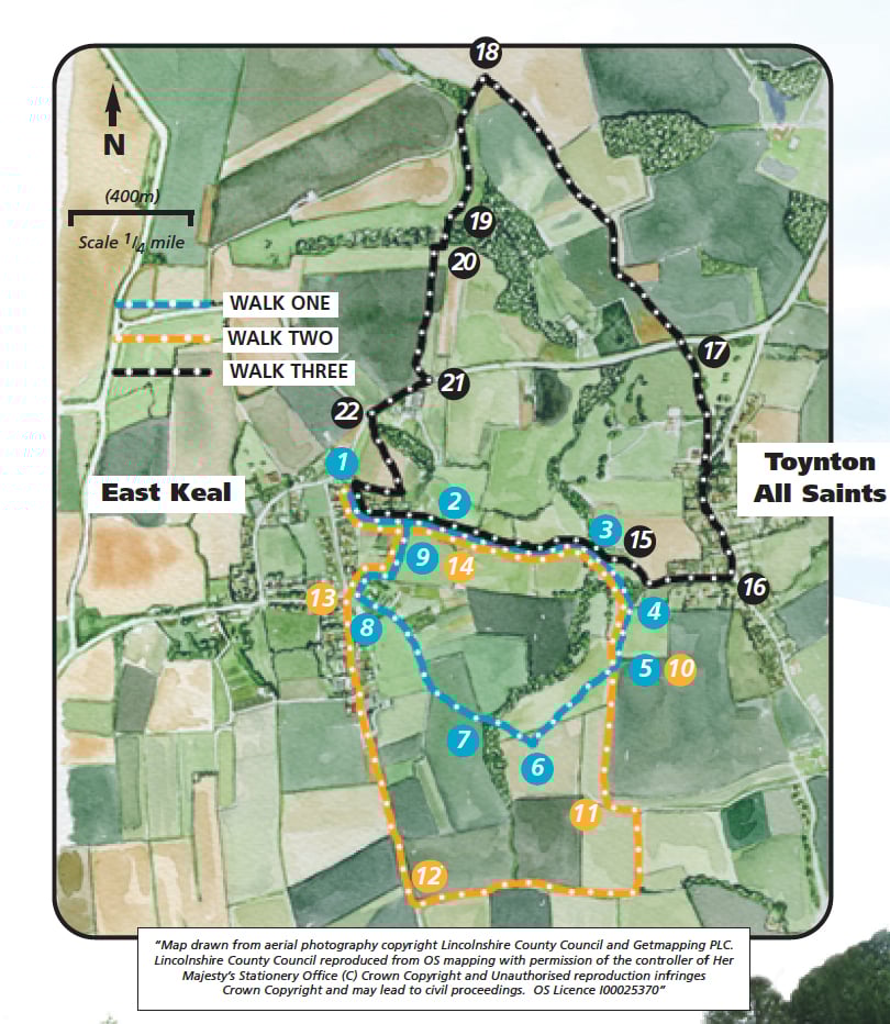
This is one of three walks at East Keal set on the southern edge of the Wolds where they fall away to the Fens. The walks cross a variety of landscapes from undulating hedged pastures to the wide open fenland fields.

By the time of the Domesday Book East Keal was well established. The name Keal originating from kjolr, Old English meaning ‘a ridge’. The underlying geology is Jurassic clays, and the village had its own brickworks until 1906 when bricks started to be massed produced in Peterborough. Many of the village cottages were built using the local bricks.

Toynton All Saints is also documented in the Domesday Book. Known as Totintun, meaning the farmstead or village associated with or called after ‘Tota’ from the Old English, the affix comes from the church dedication. It was a well known medieval and post medieval pottery centre. In 1958, a complete decorated jug was discovered. Later excavations by Mrs E. H. Rudkin in a field known as The Roses, located a kiln and a number of complete or near complete jugs. The decorated jugs associated with the
Toyntons were made from local Jurassic clay and were usually red/yellow in colour with an olive green glaze over the upper part of the jug. Motifs, often of elaborate design, were applied in a thin line of dark brown slip.

The route you will walk from East Keal through to Toynton used to be the main thoroughfare between the villages before the days of the turnpike (now the A16) and was known as Boston Lane. History records trade inpottery and other goods along this route, including the collection of flour from Toynton All Saints for the bakery in East Keal.

Starting point: The General Store at East Keal.
Grid reference: TF 097 169.

  • Linked to Public TransportLinked to Public Transport
  • RefreshmentsRefreshments
  • Dog FriendlyDog Friendly

The church was built during the 13th and 14th centuries but the west tower was rebuilt in the Early English style in 1853 after the original fell down.

The farmhouse on the left of the two bridges is old Toynton watermill. It was working until 1927. The iron mill wheel was removed in 1939 as part of the war effort. At the time of its closure, it was said to be the only overshot wheel in Lincolnshire.

The wooded area on the right bordering the stream, between points 5 and 6, is Lilley’s Carr, a nature reserve. Originally known as Mrs Varley’s Carr, who lived in a hovel in the area, it is the southern most of a series of alder carrs in the wolds. Look out for blackcaps, garden warblers, willow tits and treecreepers.

Alder trees are often found growing along the edge of the water or in wet conditions.
When cut the wood is a blood orange colour and throughout history this has given rise to the belief that the tree is associated with evil spirits.

  • 1Walk down Church Lane, past St Helen’s church and the Old Rectory and through two gates.
  • 2Keep on the bridleway, which bears left, across the field to a gate. Follow the bridleway downhill, by keeping the fence and hedge on your right, to a gate and two footbridges.
  • 3Cross both bridges and turn immediately right (following the yellow footpath arrows) and walk up the hill (avoiding the farm track) to a stile in the hedge on the left.
  • 4Turn right and follow the footpath along the hedge line and onto to the next footpath sign.
  • 5 Bear diagonally right across the field to another footpath sign in the distance. There are good views from here across the fens to Boston Stump approximately 24 km (15 miles) away.
  • 6Turn right and walk across the field and over a stream.
  • 7Walk straight across the next field. The tower of East Keal church can be clearly seen on your right. At the sign and dyke turn right and follow the field edge to the field corner. Go through the gate and follow the path between hedges to a track. Turn left and follow the track and footpath, through a gate, and straight on along a tarmac lane.
  • 8Just before the road junction turn right along the public footpath between the houses. Where the path emerges into a field turn left and follow the field edge towards the church.
  • 9At the church turn left up Church Lane to return to the starting point.

This walk uses field paths, tracks and lanes. You may encounter stiles and livestock.

more information

Starting point: The General Store, East Keal, PE23 4AT

Grid reference: TF 097 169