


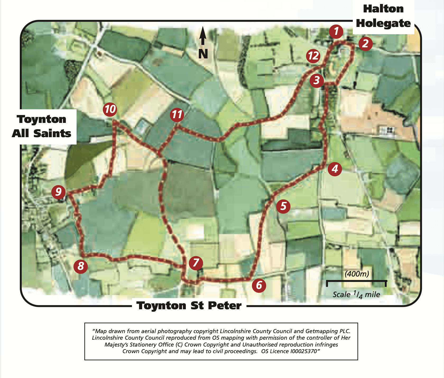
- 1From the pub walk eastwards down the hill heading towards St Andrew’s Church.
- 2As the road bends to the left take the public footpath on the right to the church. Follow the path along the hedge and past the church and out into the field. Bear diagonally right to the far right corner of the field. Follow the footpath through a private garden to the road.
- 3Turn left, walk past the school to the second public footpath on the right, as the road bends. Continue in the same direction through a copse, paddocks, gardens and riding arena (following the waymarkers) to a bridge. Cross the bridge and keep straight ahead along the edge of the next field to the road.
- 4Turn right and follow the road for approximately 50m. Turn right into the field following the public footpath sign. Walk along the edge of the field keeping the hedge on the right for 300m then bear diagonally left across the field to a wooden bridge. The tower of St Peter’s Church at Toynton St Peter can be seen ahead.
- 5Cross the two bridges and bear diagonally right to a tree in the hedge and to a waymarker post. Go through the hedge and cross the field by bearing diagonally left and following the footpath sign to the tree and gap in the hedge line and another footpath sign. Cross into the next field and bear left across the field to another footpath sign on the roadside, halfway along the field hedge.
- 6Turn right and follow the road into Toynton St Peter. In the village turn right along the road signed Toynton All Saints and then right along Church Lane.
- 7Turn left along the public footpath between the barn and the church, through the churchyard to a field. Cross the field by bearing slightly left to a bridge in the hedge.
- 8Cross the bridge and walk along the field edge with the hedge on your right to a gate. Walk straight ahead continuing along field edges and through gates to a field corner where footpaths meet. Turn right and follow the footpath across the field to a bridge in the hedge ahead. Cross the bridge and turn left along the field edge. At a corner and telegraph pole bear left to walk beside paddocks to a lane.
- 9Turn left to visit the village of Toynton All Saints, or to continue the walk turn right and follow the lane as it turns into a track and bends sharp left then right. Take the public footpath on the left, immediately after the bends, beside an area of trees.
- 10At the track turn right along the public bridleway and past a number of fishing ponds. At the next junction of tracks and bridleways turn left along the track marked public bridleway.
- 11 At the next junction of tracks turn right along the track and bridleway. Follow the track as it turns into a tarmac road and enters Halton Holegate. At the end of the lane turn left to return to the starting point.