


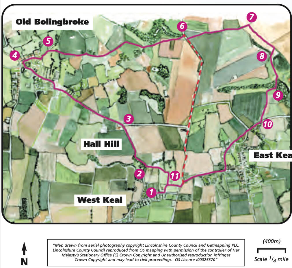
- 1Walk along Church Lane. At the top of the lane bear left on to a public footpath, and cross the field heading towards the church. Walk along the top edge of the second field and enter the churchyard through the gate.
- 2Leave the churchyard through the main gate, to the left of the church, and follow the lane straight ahead. At the end of the lane turn right and follow the tree-lined road for approximately 0.5 miles (800m) to a road junction.
- 3 Follow the road left to Old Bolingbroke. In the village follow the road to the right signed Mavis Enderby. At the end of the road at a T-junction turn right and then almost immediately left along Moat Lane to the entrance of Bolingbroke Castle. Carry on along the lane to a road junction.
- 4Turn right, past St Peter’s and St Paul’s church, and follow the road through the village and stay on it as it bends left, signed Spilsby.
- 5After approximately 200m and just before the village sign turn right onto the public footpath. Follow this path up hill and to the right of the large ash tree.
- Follow the path across the next field by bearing slightly right to the hedge and tree, and then continue by walking along the other side of the hedge.
- Follow the path until it comes out into a field. Walk straight across the field to the right end of the hedge. Then follow the field edge with the hedge on your left. Continue along the edge of the next field.
- At the gap in the hedge on the left and corner of the fields bear right following the footpath sign to a hedge. Follow the sign posted route from the end of the hedge by bearing left to a bridge.
- Bear left uphill across the next field to the edge of the woodland and a footpath sign. Continue in the same direction to cross the field to the road.
- 6Cross the road, turn right and almost immediately turn left to follow the public footpath across the field to a footpath sign on the horizon. At the sign turn right and follow the track, ignoring a footpath on the left. The path continues beside a hedge and area of tree planting.
- 7Where the footpath meets a bridleway, in front of a barn, turn right along the bridleway. After approximately 500m and at the next path junction turn right along the footpath.
- 8Approximately 50m after the stream turn left onto another footpath and follow the path to the entrance into Keal Carr Nature Reserve. Enter the reserve and follow the footpath along a boardwalk and up some steps.
- 9Follow the footpath out of the reserve and walk straight ahead along the fence line for 50m before turning left across the field heading towards the barns on the far side of the A16 road.
- 10At the A16 turn right and follow the roadside path. Take the public footpath on the right immediately after the road to Old Bolingbroke. At a junction of paths and in front of a house turn left, to return to the A16. Turn right and follow the roadside path for approximately 0.75 miles (one kilometre). (You will cross the A16 twice to follow the roadside pavement).
- 11Take the public footpath on the right just after the turning to Old Bolingbroke and cross the field., Walk in front of the farm buildings and across the yard and continue straight on between bungalows to Church Lane. Turn left to return to the starting point.
