(7.64km)
30 mins
Walking
Wainfleet St Mary Walk
Wainfleet St Mary
Enjoy a walk from Wainfleet through the surrounding countryside crossing the Steeping River, the site of the medieval village of Wainfleet, walking along a medieval drove road before returning to Batemans Brewery Visitor Centre.
Starting point
Batemans Brewery Visitors Centre
Mill Lane
Wainfleet All Saints
PE24 4JE
Grid reference: TF 494 586
Linked to Public Transport
Refreshments
Dog Friendly
The parish of Wainfleet St Mary sits on the south side of the Steeping River with the small town of Wainfleet All Saints sitting on the north bank.
During the medieval period Wainfleet was a coastal town and a significant port, with wool and grain being exported. The port went into decline as the river silted up and Boston became an important trading port. The medieval settlement of Wainfleet was located 2 miles west of the current settlement but all that remains today are earthworks across a number of fields.
This rural walk passes a Quaker burial ground, crosses the site of the medieval settlement of Wainfleet, uses what is thought to be a medieval drove road and skirts the boundary of a woodland.
The tower mill at the brewery, known as Salem Bridge Mill, was built in 1820 and worked for 100 years until 1920. It was then bought by Batemans and used as part of the brewery and is now a listed building.
St Mary’s church dates to the Norman period (1066-1200) and is a survivor of the nearby medieval village. Much of the church was restored during the 19th century.
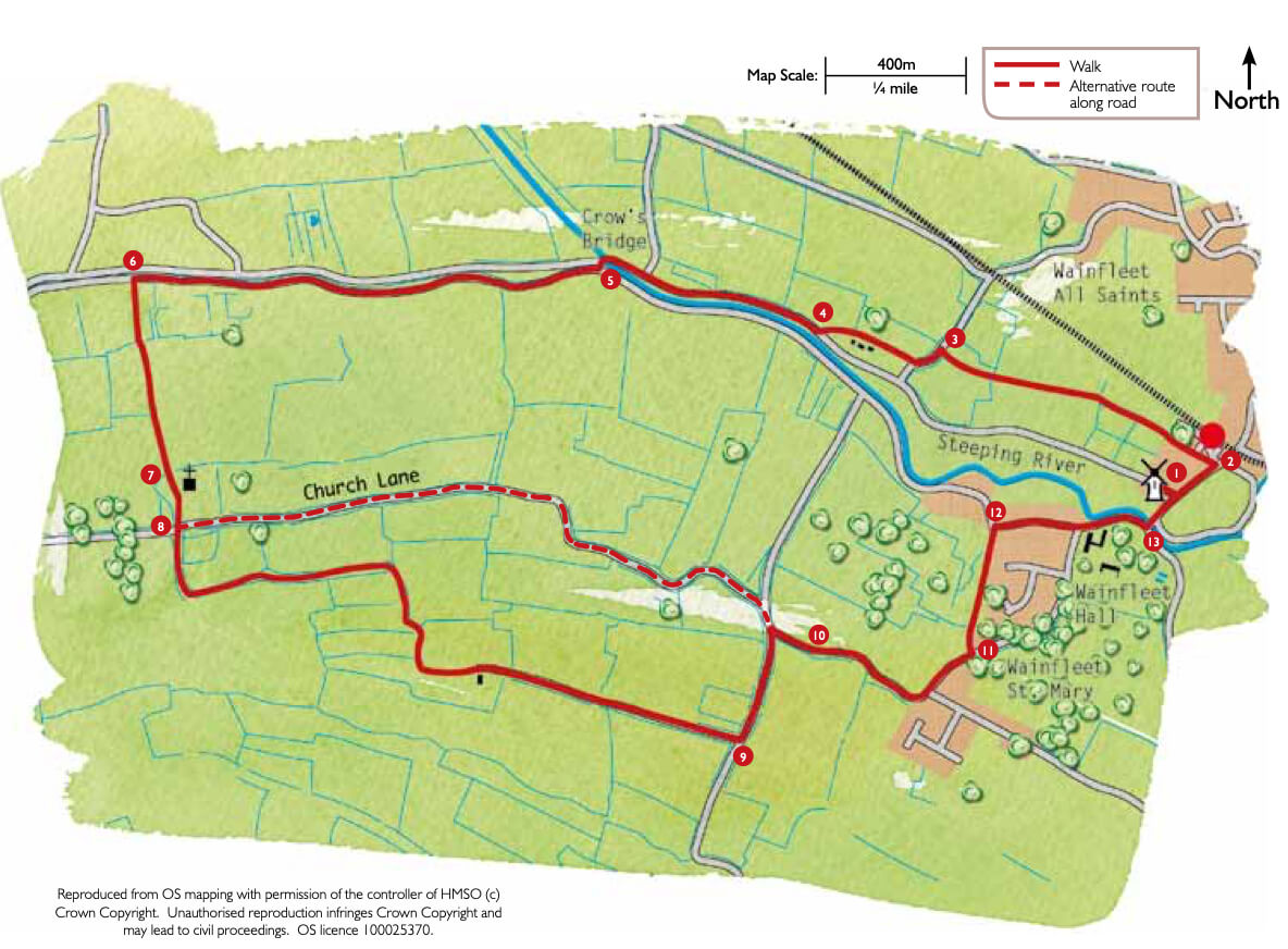
- 1Leave the Visitor Centre car park and turn right.
- 2At the T-junction turn left and after approximately 100m, opposite All Saints’ church, turn left onto a public footpath. Follow the path beside the houses and then straight on between two ditches. Cross a bridge and continue ahead between two fields to another bridge. Cross the bridge and follow the field edge ahead to a road.
- 3Turn left and follow the road for approximately 75m before turning right onto a public footpath around the back of some houses to rejoin the road.
- 4Turn right and follow the road to the river. Cross the river over Crow’s Bridge. You are now in the parish of Wainfleet St Mary.
- 5Immediately after the bridge turn left and then right along Wainfleet Bank. Follow the road for approximately 0.75 miles (one kilometre).
- 6Turn left onto a public footpath heading towards St Mary’s church. Cross the bridge and continue ahead keeping the hedge on your left. After approximately 150m and at a large gap in the hedge, go through the gap and carry on in the same direction but with the hedge now on your right.
- 7Cross the bridge into the churchyard and walk straight ahead to join the church path to the road.
- 8Here you have a choice of routes, one along a quiet country road and the other along a public footpath.
- COUNTRY LANE ROUTE: Turn left along the road (Church Lane) and follow it for approximately 1.5km (1 mile) to a T-junction. Turn right and at the second T-junction turn left, signed Wainfleet. Rejoin the walk at point 10.
- FOOTPATH ROUTE: Cross the road and follow the public footpath opposite, along a track. Continue along the track as it passes a cottage and becomes a surfaced lane leading to a road junction.
- 9Turn left and at the next road junction keep right towards the village.
- 10Follow the road for approximately 600m, past the windmill and St Michael’s Lane.
- 11Turn left onto a public footpath, opposite the play park and adjacent to the Jubilee Orchard. Cross the small grass area and follow the path between two hedges, to the right of the house, and then straight on behind the houses to a road.
- 12Turn right and at the T-junction turn left to walk alongside the river.
- 13At the next T-junction turn left over Salem Bridge to return to Wainfleet All Saints. Take the first left, Mill Lane, to return to the starting point.
The walk uses roadside paths, field paths, quiet roads and tracks. There are stiles and you may encounter livestock.
more information
Starting point
Batemans Brewery Visitors Centre
Mill Lane
Wainfleet All Saints
PE24 4JE
Grid reference: TF 494 586
things to do in the area
Battle of Britain Memorial Flight Visitor Centre (BBMF)
Chapel St Leonards – Coastal Country Park Walks
Gibraltar Point Nature Reserve
Humber to The Wash Cycle Route
Butlin’s Big Weekenders – Skegness
Lincolnshire Aviation Heritage Centre
Lincolnshire Coast Light Railway
Orchard Farm Equestrian Centre
The King Charles III England Coast Path
Chapel St Leonards to Skegness Promenade Cycling
Cleethorpes Seafront Birdwatching
Donna Nook National Nature Reserve Birdwatching
Huttoft Bank Pit Nature Reserve
Lincolnshire Coastal Country Park Birdwatching
Saltfleetby-Theddlethorpe Dunes Birdwatching
Sutton on Sea to Chapel St Leonards Promenade Cycling
The Ship Inn, Chapel St Leonards
Alford to the Coast Cycle Route
Dobson’s Mill & Heritage Centre Burgh le Marsh
Lincolnshire Wolds’ Challenge Cycle Route
Mumby to Hogsthorpe – Coastal Country Park Walks
Spilsby to Wainfleet All Saints Cycle Route