(6.04km)
30 mins
Walking
Chapel Point To Wolla Bank
Chapel Point,Anderby Creek
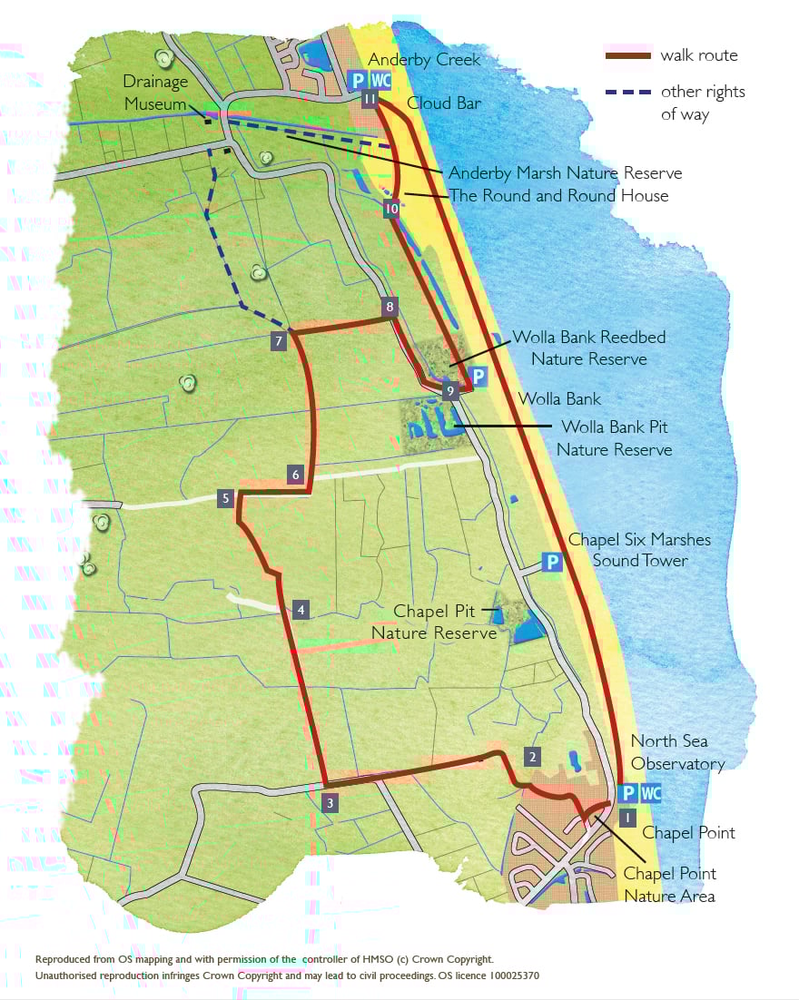
The Lincolnshire Coastal Country Park lies between Sandilands, Chapel St Leonards and Huttoft, on the quiet Lincolnshire coast.
With five miles of beautiful sandy beaches, amazing big skies and some wonderful wildlife sites, the Coastal Country Park is a great place to explore and enjoy.
It aims to create a sustainable, diverse network of wildlife habitats; support the local economy; raise awareness of its natural and cultural heritage and provide recreational opportunities.
One of the best ways to discover the area is on foot and this walk takes in the coast, arable
farmland and nature reserves.
The North Sea Observatory is a purpose-built marine observatory with fantastic views of the dunes and sea. It offers all year round facilities for everyone. The building includes information and exhibitions on the local area’s rich natural history and heritage, an art space, a café and public toilets. It is an impressive gateway to the Coastal Country Park.
Starting point and car park: North Sea Observatory, Anderby Road, Chapel St Leonards.
Grid reference: TF 562 732.
Post code: PE24 5XA.
what3words.com
Parking
Linked to Public Transport
Refreshments
Dog Friendly
Between points 3 and 4 look out for the pill box in the hedgerow on your right. It would have formed part of the Second World War coastal defences built when the country was under threat of invasion during 1940. You may see others as you travel around the local area.
Wolla Bank reedbed nature reserve is on your left as you walk along the bank. After clay was scraped from here to carry out repairs to the sea wall the area developed into reedbeds. Reed warbler, sedge warbler, reed bunting, and whitethroat all nest here. In spring you might be lucky enough to see marsh harriers and hear bitterns.
The blue tower like structure on the edge of the dunes is the Sound Tower. It is a structure designed to focus and concentrate people’s senses and amplify the windy nature of the area. It is a clear point of reference in the landscape, identifiable from land, sea and beach. It is one in a series of structures that are part of the Structures on the Edge, small scale art-led interventions forming a linear gallery of coastal architecture.
- 1Leave the car park via the entrance, cross the road, turn left and then immediately right, past Chapel Point Nature Area. After approximately 90m turn right onto a public footpath through the entrance of Eastfields Park. Take the second road on the left, signed public footpath, and after approximately 60m bear diagonally right to the far corner of the grassed area. Turn right and walk between the rows of chalets to a bridge.
- 2Cross the bridge, turn left and walk around the edge of the caravan park to a gate. Go through the gate, and follow the driveway past the house and out of the caravan park to join a road. Follow the road straight ahead for approximately 400m to a T-junction. Continue straight ahead along the road for approximately 200m.
- 3Turn right along Stones Lane.
- 4At the end of the lane, by a small compound, carry straight on, keeping the drainage ditch on your right. Follow the drain for approximately 550m to a junction with a track and footpath.
- 5Turn right and follow the footpath as it bends to the left.
- 6As the path bends to the right, leave this path and walk straight ahead along another footpath, keeping the ditch on your left. Follow the path straight on as it becomes a track.
- 7At a junction of paths, turn right over a bridge and walk straight ahead along the field edge to a road.
- 8Cross the road with care and walk up the track opposite, turn right and follow the permissive path along the top of Roman Bank to Wolla Bank.
- 9At the road turn left to the car park. Walk straight ahead on to the beach, turn right and walk along the beach back to the North Sea Observatory.
This walk uses field paths, quiet roads, tracks and the beach. There are no stiles and you are unlikely to encounter livestock.
more information
Starting point: North Sea Observatory, Anderby Road, Chapel St Leonards
Grid reference: TF 562 732
Post code: PE24 5XA
things to do in the area
Battle of Britain Memorial Flight Visitor Centre (BBMF)
Chapel St Leonards – Coastal Country Park Walks
Gibraltar Point Nature Reserve
Humber to The Wash Cycle Route
Butlin’s Big Weekenders – Skegness
Lincolnshire Aviation Heritage Centre
Lincolnshire Coast Light Railway
Orchard Farm Equestrian Centre
The King Charles III England Coast Path
Chapel St Leonards to Skegness Promenade Cycling
Cleethorpes Seafront Birdwatching
Donna Nook National Nature Reserve Birdwatching
Huttoft Bank Pit Nature Reserve
Lincolnshire Coastal Country Park Birdwatching
Saltfleetby-Theddlethorpe Dunes Birdwatching
Sutton on Sea to Chapel St Leonards Promenade Cycling
The Ship Inn, Chapel St Leonards
Alford to the Coast Cycle Route
Dobson’s Mill & Heritage Centre Burgh le Marsh
Lincolnshire Wolds’ Challenge Cycle Route
Mumby to Hogsthorpe – Coastal Country Park Walks
Spilsby to Wainfleet All Saints Cycle Route