Walking

Huttoft To Sandilands Walk

Huttoft,Sandilands

The Lincolnshire Coastal Country Park lies between Sandilands, Chapel St Leonards and Huttoft, on the quiet Lincolnshire coast. With five miles of beautiful sandy beaches, amazing big skies and some wonderful wildlife sites, the Coastal Country Park is a great place to explore and enjoy. It aims to create a sustainable, diverse network of wildlife habitats; support the local economy; raise awareness of its natural and cultural heritage and provide recreational opportunities. One of the best ways to discover the area is on foot and this walk will take you through a variety of landscapes including a tree-lined disused railway line, now a nature reserve, across fertile arable farmland and along the coast.

Walk location: Huttoft Bank is located on the coast approximately 1.5 miles south of Sandilands, at the northern end of the Coastal Country Park.

Starting point and parking: Huttoft Car Terrace, Huttoft Bank Grid reference: TF 541 786.
Post code: LN13 9RT or car park on Roman Bank, Sandilands Grid reference: TF 530 804. Post code: LN12 2RJ.

  • ParkingParking
  • Linked to Public TransportLinked to Public Transport
  • RefreshmentsRefreshments
  • Dog FriendlyDog Friendly

The Louth and East Coast Railway opened the line in 1877, linking Louth to Mablethorpe. The line closed in 1970 as part of the Beeching cuts and the track removed in 1971. This section of the line has been managed as a nature reserve by Mablethorpe and Sutton Town Council. A variety of native trees and shrubs have been planted to encourage wildlife, including hawthorn, hazel, spindle, dogwood, ash, oak and cherry. It is a great place to do some bird watching. Look out for barn owls, jays, blue tits, great tits, goldfi nch and sparrowhawk to name but a few.

The verges of the track between point 10 and 11 are designated a Roadside Nature Reserve (RNR) by Lincolnshire Wildlife Trust and Lincolnshire County Council. Plants found include dyer’s greenweed, a small shrub with yellow flowers that gets its name from the yellow dye obtained from its stems and common restharrow, a trailing plant with pink fl owers that got its name from its ability to slow down horse drawn harrows in the days before tractors. With the wide variety of plants and the nearby drain the area is good for dragonflies and butterflies. Also keep your eyes open for heron, marsh harrier, barn owl and kestrel.

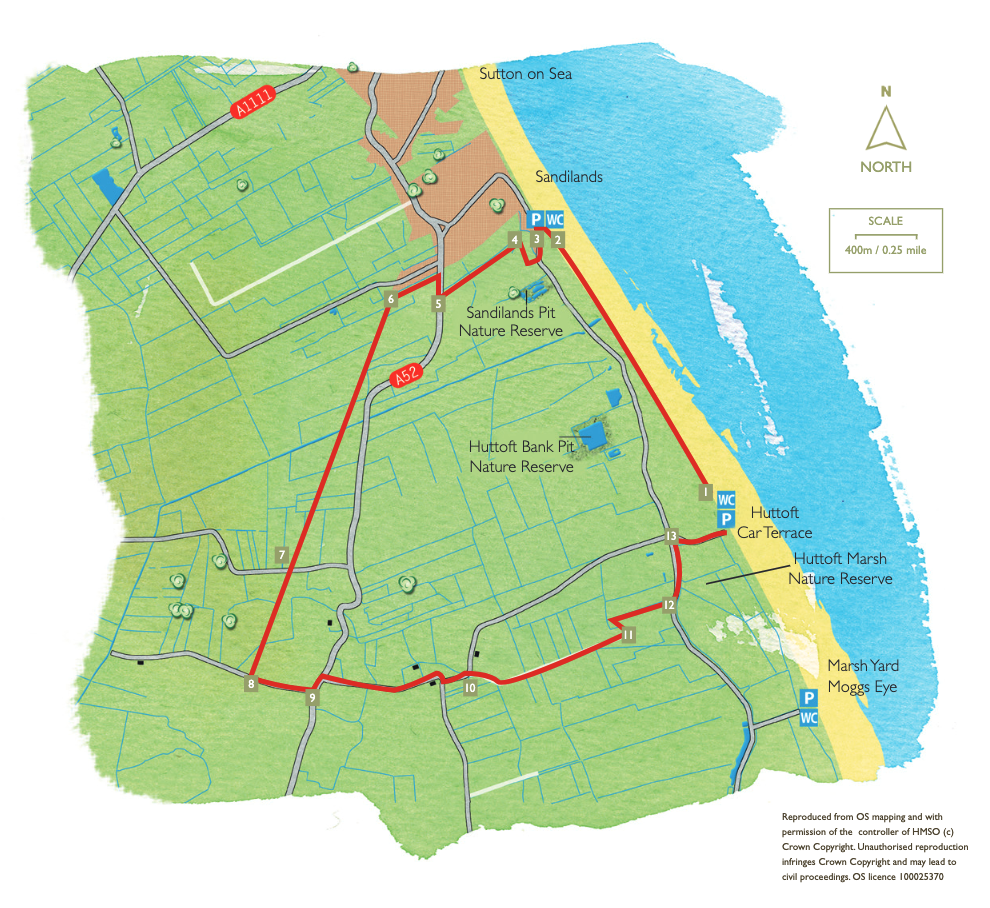
  • 1From the car park access ramp walk through the smaller car park to the north and carry straight on along the concrete sea wall, part of the England Coast Path. Follow this for approximately 2.5 km ( 1.5 miles) towards Sandilands. Sand may cover the sea wall at certain times of year. Alternatively you can walk along the beach. As you approach Sandilands walk past the fi rst row of beach huts to a gap.
  • 2Turn left and leave the sea wall, down some steps, to the car park. Walk across the grass area behind the toilets to the road.
  • 3Turn left along Roman Bank and then right onto a public footpath at the entrance to Masons Close. Follow the path to the right of the bungalow ahead and turn right around the edge of the yard and then behind a barn. Follow the path straight across a small fi eld to a bridge.
  • 4Cross the bridge, turn left and follow the path beside the drain to a road.
  • 5Turn right and walk along the verge for approximately 100m. Turn left onto a public footpath, taking care crossing the road. Follow the path beside the ditch, over a bridge and then straight on to a junction with another footpath.
  • 6Turn left and follow the path straight on along the former railway line known as the Sutton Branch Line Walkway. Cross a large drainage channel and continue straight on along the old railway line for approximately 900m (just over 0.5 mile) to a road.
  • 7Cross the road and walk along the footpath opposite, beside a hedge, to reach another road.
  • 8 Turn left and follow the road to a T-junction.
  • 9 Turn left onto the footpath along the field edge. Cross the road with care and walk along Sea lane, taking care crossing the road walk along Sea Lane past a farm on the left. The road will then bend to the right, left and then to the left again.
  • 10At this last bend leave the road and walk straight ahead along a track with a drain on the right. Follow the track for approximately 1 km (0.6 mile) to its end and the edge of a fi eld where there is a fingerpost and owl box.
  • 11Turn left and follow the path beside a ditch, then across a small field to another ditch. Turn right and follow the path to the road.
  • 12Cross the road with care, turn left and walk along the road for approximately 80m (take care as this road can be busy during the summer months). Walk up onto the roadside bank and continue in the same direction along the bank to the road that leads into Huttoft Car Terrace.
  • 13Turn right to return to the car park and starting point.

This walk uses the sea wall (or sandy beach), field paths, and quiet roads.

There are no stiles or livestock.

more information

Starting point: Huttoft Car Terrace, Huttoft Bank (south end of Sandilands golf course)

Grid reference: TF 541 786

Post code: LN13 9RT

Alternatively use the car park on Roman Bank, Sandilands (north end of Sandilands golf course)

Grid reference: TF 530 804

Post code: LN12 2RJ