


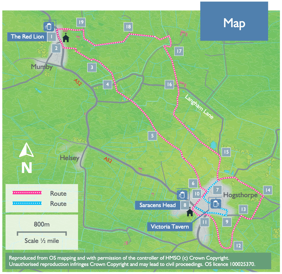
- 1With your back to the pub turn right. Cross the main road (A52) with care and follow the road/layby in front of the church.
- 2Take the public footpath on the left adjacent to the old Methodist chapel. Cross the bridge and follow the path to the right, between a hedge and fence. Cross another bridge and turn left to follow the path between hedges to a bridge. Cross the bridge and continue between hedges to a gate and field.
- 3Walk straight across the field to a waymarker post next to a drain. Turn left and follow the field edge and drain to a bridge.
- 4Cross the bridge and walk straight on alongside the drain. At the end of the field carry straight on over the bridge and follow the path straight on to a road. Cross the road and follow the public footpath straight ahead across a field to a bridge in the hedge. Cross the bridge and follow the path ahead along the field edge. At the field corner cross the bridge and track and continue straight on across the middle of the field to a bridge. Follow the path diagonally right across the field to the corner.
- 5Go through the hedge and bear diagonally right across the field corner. Go through the hedge and cross the field by bearing left to a bridge. Walk straight ahead beside the drain to another bridge. Continue on beside the drain. Cross another bridge and continue beside the drain, which is now on your left. Cross the farm bridge and continue ahead along the field edge. Bear left over a small bridge and walk straight ahead. At the field corner bear diagonally right to the corner of the metal fence.
- 6Go through the gate and along the edge of the playing field and past Hogsthorpe Village Hall to a road.
- 7 Turn right and follow the road to a T-junction with the A52. Look out for the Saracens Head pub and the village information boards.
- 8Turn left and follow the High Street. As the main road bends to the right turn left onto Mill Lane. Follow Mill Lane for approximately 250 metres.
- 9Turn left onto Mill Lane Close and then left onto Goodwin Drive and follow the road straight ahead to a T-junction.
- 10Turn right, walk past the school and village hall. Take the first turning on the left, Langham Road and follow the road for approximately 350 metres to where it bends to the right.
- 15Leave the road here to follow the No Through road straight ahead. Continue as it becomes a track and reaches a road, approximately 1200 metres (0.75 miles).
- 16Cross straight over the road to follow a public footpath slightly left across the fields, heading towards the house and barns. Cross over a culvert, to a gap in the hedge and a track.
- 17Turn right then almost immediately left to walk along the track towards a house, Wesley Farm House. After approximately 100 metres turn left onto a path across fields to a bridge. Cross the bridge and bear right to another bridge. Turn right then almost immediately left to walk alongside the drain, keeping the drain on your left.
- 18At a fingerpost and where the drain turns left, turn left and follow the grass track. Follow the track as it becomes a tarmac lane and reaches a road junction.
- 19Turn left towards Mumby village. At the T-junction with the A52 turn left to return to the starting point.