


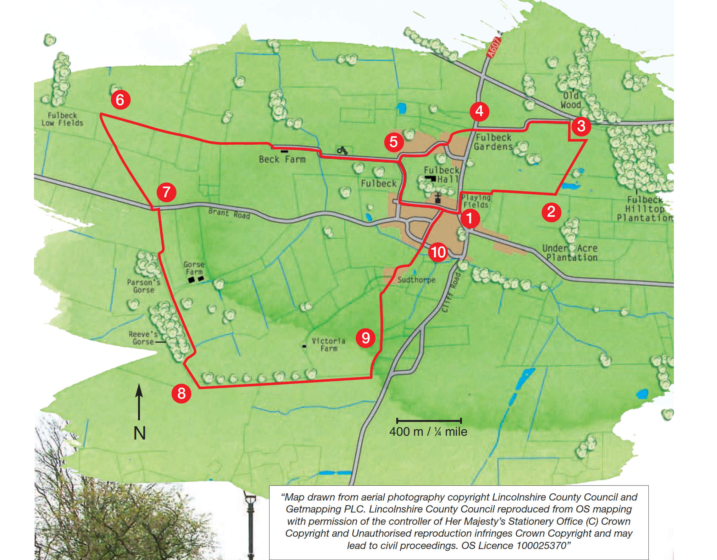
- 1Leave the car park and turn right along the main road. After approximately 30m turn right through a gap in a wall and follow the public footpath along the edge of the playing field. At the corner of the playing field go over a stile, turn right and continue on in the same direction with the hedge now on your right.
- 2At the end of the field go through two gates, crossing a track which was once the Honington railway line, and then bear diagonally left across the field towards a telegraph pole and way marker post.
- 3Bear right across the field to a waymarker post to the left of a large oak tree. Turn left and walk beside the old hedge to another waymarker post close to the corner of the substation fence. Turn right along the bridleway (beside the fence) to a gate and road. Turn left on to North Heath Lane. Walk along the lane to the junction with the A607, crossing the disused railway line again.
- 4Cross the main road with extreme care and go through the gate opposite. Bear diagonally left towards the houses, reaching another gate and tarmac road. Follow the road ahead and turn right after 100m and walk down the road to the bottom of the hill.
- 5Bear left and then second right to follow a tarmac lane marked as a public bridleway and no through road. Continue along this lane which eventually becomes a farm track, for approximately one mile (1.75 kilometres). Where the track bears right towards a farm, continue straight ahead on the bridleway, keeping a hedge on your left.
- 6At a sign where the bridleway crosses a footpath turn sharp left to follow the path diagonally across a field to a bridge in the hedge line. Continue on the same line across a second field, using a distant church spire and mast on the horizon as your aim.
- 7Cross over the minor road and follow the bridleway along the field edge, with a hedge on your left. After approx. 300m follow the bridleway and turn right across the field to the corner of the wood. Turn left and walk alongside the woodland and up the hill. Turn right at the end of the second wood and field corner. Walk around the field edge.
- 8On reaching the top of the ridge, and at a junction of bridleways, turn left along a grass track towards Fulbeck. Carry on along this track for approximately 0.66 miles (one kilometre), passing a radio mast and then a farm on your left.
- 9Just before meeting the main road, at a junction of a footpath and a bridleway, turn left and walk along the field edge. Turn right over a footbridge and then go diagonally left across the field towards a house and footpath sign. Go down the narrow path between the houses. Continue ahead down the tarmac lane.
- 10Go straight ahead at the crossroads, following the High Street as it runs up through the village. Continue straight ahead at the junction with Scots Hill, and then turn right at the Hare and Hounds pub. Walk back to the main road and the car park.