


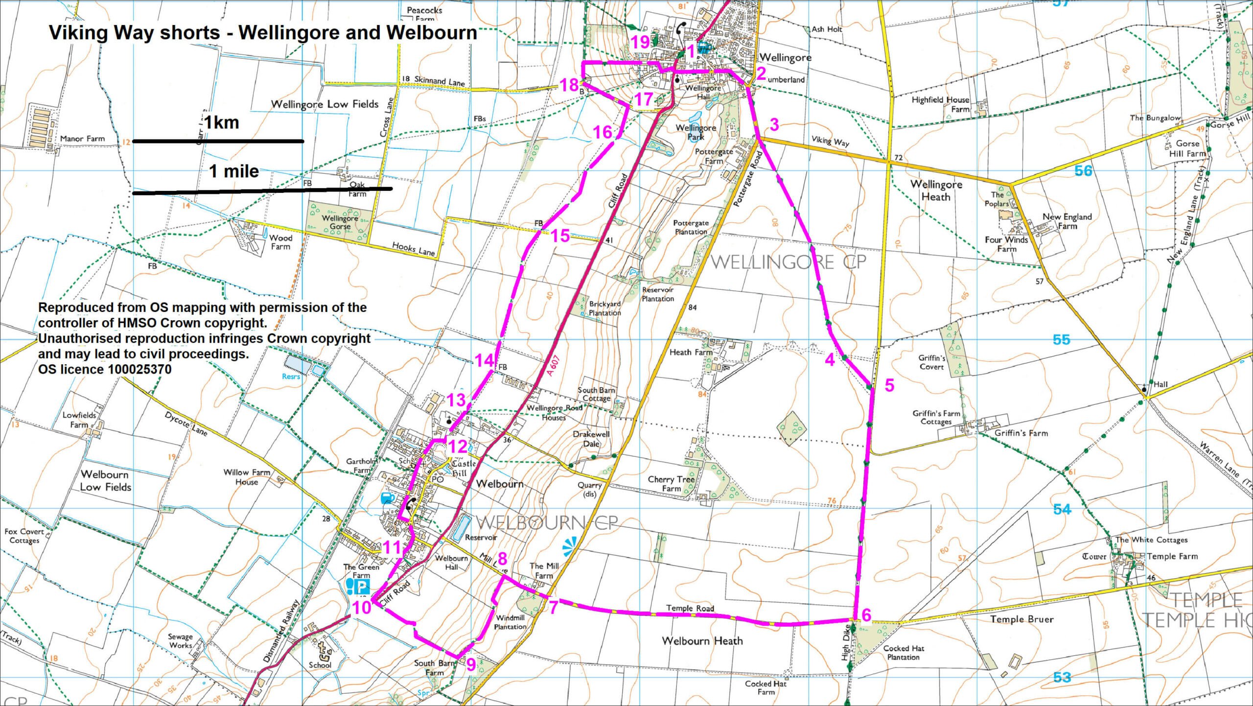
- 1Walk along Hall Street, signed Viking Way, to a T-junction.
- 2Turn right along Pottergate Road to the next road junction.
- 3Turn left and take the footpath on the right from the field corner and walk diagonally left across fields for approx. 1.4 km (0.9 mile) to a concrete roadway.
- 4Cross the roadway and follow the path diagonally left across the next field to a tarmac lane.
- The concrete roadway formed part of RAF Wellingore. Look out for old airfield buildings in the area. The airfield was first used during World War I for RAF Cranwell’s relief landing. In closed in 1945 after playing a role in World War II. Post-war the station served as a camp for ex-prisoners of war from Germany and the Ukraine before being returned to agriculture in the 1950s. Look out for perimeter pill boxes later in this walk.
- 5Turn right, you are now walking along Ermine Street. Where the lane bends to the left continue straight ahead along a grass track and Viking Way to a junction with a road.
- 6Turn right, leaving the Viking Way, and follow the road to a crossroads.
- Notice the wide verges either side of this road. These grass verges form an ideal habitat for a range of colourful wildflowers.
- 7Cross the road with care and continue straight ahead signed Welbourn for approx. 300m
- 8Turn left onto a public footpath and follow it along the field edges for approx. 550m to a farm.
- There are fabulous views from this path across the Trent and Belvoir Vales and along the Lincolnshire edge towards Lincoln.
- 9Turn right onto footpath and walk downhill along field edges to a road.
- 10Cross the road (A607) with care and walk into the layby to join a footpath. Follow the path to the right, parallel to the fence/hedge to the side of the stone cottage and on to a road.
- 11Continue straight ahead into Welbourn village and a T-junction. Turn left (signed Welbourn village) and at the village green turn left and then bear right along the High Street.
- 12After approx. 600m turn left on to North End to an Anglian Water cabinet/installation.
- 13Turn right and at the field edge bear diagonally left across the field to a gap and bridge in the hedge to the left of the farm sheds.
- 14Walk straight across the next few fields to a road.
- 15Cross the road and take the footpath opposite by bearing slightly right towards the houses on the hill (Wellingore) and a bridge.
- 16Cross the bridge and bear slightly right to a gap in the hedge and road.
- 17Turn left along the road for approx. 300m
- 18Turn right onto a restricted byway and after approx. 100m turn right along a restricted byway to walk uphill into Wellingore village.
- 19At the road walk straight ahead to the green. Turn right and then left onto Vicarage Lane to a crossroads. Cross the road (A607) with care to church and starting point.