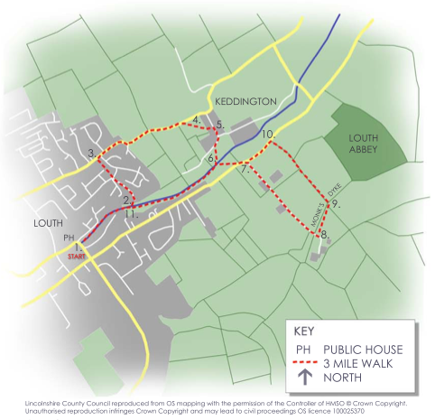
Walk
Loop
3miles
(4.83km)
1 hour
30 mins

Walking

The Elvin Round Walk 

Add to favourites

This walk has been named after the Elvin Sisters, who cared for St Margaret's Church throughout their lives. They were renowned for their twice daily walk around the church. When they passed away they bequeathed their estate to St Margaret's. This fund now pays for the ongoing maintenance of the churchyard.

Starting point
Louth Riverhead
Louth
Lincolnshire
LN11 0DD

Points of interest:

Canal
Louth Navigation Canal used to connect Louth to the River Humber via Tetney Lock, just eleven miles away. Its eight locks accommodated the 46ft difference in level between the two points.

The canal was built in 1770 for the purpose of transporting wool and corn but closed in 1924 after struggling to compete with the arrival of the railway in 1854.

For more info please see www.louthcanal.org.uk

The story of Keddington begins in the Anglo-Saxon period when Louth developed as a regionally important market centre.
Keddington is recorded in the Domesday book of 1086 as 'Cadinton', which is Old English for
'farmstead, village associated with or named after Cedda'.

From the path you can see the Grade II* listed church of St Margaret and its Anglo-Saxon window. A carving of an animal, thought to be a seal, lies under the arch. The church was deconsecrated in 1998 and is now in private ownership but you can see artefacts of interest at Louth Museum, including the tablet commemorating the exhumation of Greek poet Andreas Kalvos and a section of C13th Cross.

Louth Abbey
Louth Park Abbey was founded in 1139 by Cistercian Monks from Fountains Abbey under Bishop Alexander of Lincoln. Unfortunately, the abbey is on private land but the man made 'ditch' you are walking alongside is an important part of the abbey. Known as the Monk's Dyke, this waterway carried fresh water to the abbey.

In 1536 the abbot and local vicar incited the Lincolnshire Uprising to protect a group of nuns from Henry VIlI's commissioners. Thirty-eight men were executed, the instigators being sent to London to be hung, drawn and quartered for their part in the rebellion. Shortly after this the abbey was dissolved. Parts of the abbey are believed to have been incorporated into St Margaret's Church during the Victorian renovations.

  • 1From the Riverhead, take the path along the north bank of the river to the large Tilting Wier, originally Town Lock.
  • 2Stay on the left hand side of the canal and follow the sign pointing ahead which leads you along a track and public footpath to Keddington Road.
  • 3Turn right and follow the minor road for 600m. Go through the kissing gate that appears in the hedge to your right.
  • 4Head across the field towards the church until you enter the churchyard and pass through to the road beyond (this section by kind permission only and could be withdrawn at any time).
  • 5Turn right out of the churchyard. After 20m turn right down River Lane until a footpath branches off to the left. This path leads to the canal.
  • 6At Keddington Lock cross both the canal and the River Lud. Follow this path until you reach the road.
  • 7Turn left along the road until you see a marked footpath along a private road on your right (to Louth Park Farms).
  • 8At the end of this road you will cross the 'Monks' Dyke' and enter a farmyard (deviating from the OS maps as field boundaries have changed). From the farm yard take the path to the left over the stile.
  • 9After 150m turn left and head to the road.
  • 10At the road turn left back towards Louth until you rejoin the path to Keddington Lock across the road on your right.
  • 11On reaching the canal follow the towpath on the left of the river, which leads back to the Riverhead.

Flat and easy. Mainly footpaths with some roadside walking.

more information

Starting point

Louth Riverhead

Louth

Lincolnshire

LN11 0DD