Walk
Loop
5.5miles
(8.85km)
2 hours
45 mins

Walking

Boothby Graffoe Long Walk

Boothby Graffoe

A circular walk set in and around the attractive villages of Boothby Graffoe, Navenby and Coleby. These villages sit on Lincolnshire's limestone ridge - known as Lincoln Edge. There are spectacular views across the Trent Valley on a clear day. This walk is circular and five and a half miles (nine kilometres) in length. The walk uses field paths, tracks and minor roads.

Starting point
Main Street
Boothby Graffoe

  • Linked to Public TransportLinked to Public Transport
  • RefreshmentsRefreshments
  • Dog FriendlyDog Friendly

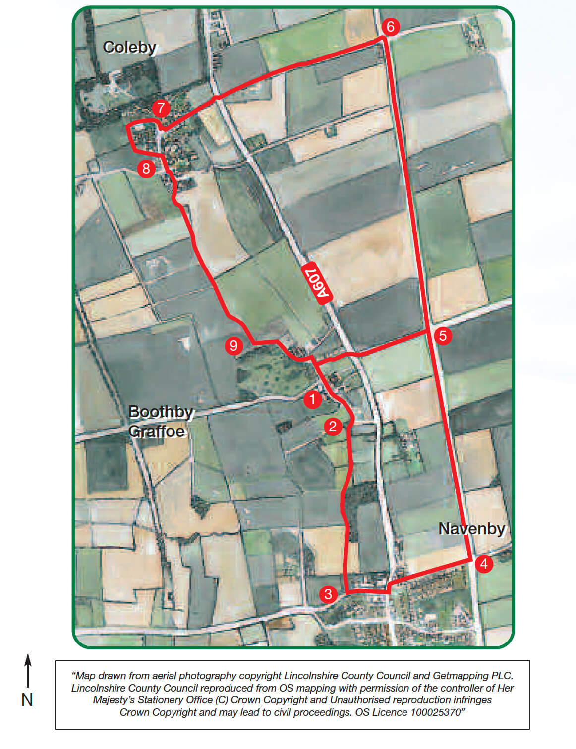
This walk is set in and around the attractive villages of Boothby Graffoe, Navenby and Coleby, small communities strung out along the impressive limestone ridge that is known as Lincoln Edge. Pick a clear day and the walk will reward you with wide horizons and spectacular views.

Lincoln Edge is part of the long limestone ridge that runs through England from Yorkshire to The Cotswolds and the south coast. A steep escarpment lies to the west and leads down to fertile agricultural land that is drained by the river Witham and its tributary, the Brant. To the east is heathland; here the limestone dips gently away until becoming submerged by the Fens.

Boothby Graffoe is just one of a chain of villages that have developed along an old ridge way track and on the spring line. A settlement has been here since the 10th century when the Danes occupied the area. ‘Boothby’ is thought to come from the old Danish word Bodebi, meaning ‘temporary shelter’ (‘Graffoe’ was not added until the 18th century and referred to the local administrative district).

Part of this walk follows The Viking Way, a long distance footpath that runs from the banks of the Humber to the shores of Rutland Water, a distance of 149 miles. Established in 1976, its name reflects the influence of the Danes in the eastern counties of Britain. Look out for the Viking helmet symbol on way markers. You will also walk along sections of a route that was laid out nearly 2000 years ago – the Roman road known as Ermine Street.

  • 1Walk down Main Street towards the church at the southern end of the village.
  • 2Where the road bends to the left to rejoin the A607, continue straight ahead along a track marked by a footpath sign bearing the Viking Way symbol. Follow the track into a field, passing a pond on your left. Continue straight ahead towards Navenby, now keeping parallel with the ridge and passing woodland on your left. Continue along the path as it runs behind some houses. Go down steps on to a road.
  • 3Turn left. At the junction with the main road turn left again and then take the first turn immediately on the right (Green Man Road), taking care crossing the busy road. (To visit the centre of Navenby turn right at the main road.)
  • 4After approx 500m, where High Dyke goes off to the right, turn left along a green lane. Continue northwards along this wide grass track for approx 1.5 kilometres (just under a mile) until you reach a junction with a tarmac road.
  • 5Cross the road and continue straight ahead along Ermine Street, now on a tarmac surface. At a radio mast, where the tarmac road veers off to the left, keep straight ahead along the track to junction with a road.
  • 6Turn left and walk along the road until it meets the A607. Cross this with extreme care and go straight along Rectory Road into Coleby village.
  • 7At the junction next to the church, turn right along Farlane. Walk past the pub (Bell Inn) to the end of the lane. Turn left along the footpath and follow it as it runs alongside the wall. Turn left over a stile and emerge next to the pub (Tempest Arms).
  • 8Now follow the Viking Way by crossing the green and turning right onto Dovecote Lane. Where the road bends to the left, turn right onto the public footpath. At the hedge and junction with another footpath turn left. Carry on along the well-worn path for approx one kilometre (just over ½ a mile), to the outskirts of Boothby Graffoe.
  • 9On reaching a small copse go through the gate on your left. Follow the track that runs diagonally across the grass paddock to the opposite corner and a house. Go through another gate and walk along the road to reach Main Street and the starting point.

This walk uses field paths, tracks and quiet roads. You may encounter stiles and livestock.

more information

Starting point

Main Street

Boothby Graffoe

more about the trail

Viking Way

The Viking Way is a long distance - 147 mile way-marked trail spanning from the River Humber through Lincoln to Oakham in Rutland. The route is signposted with an icon of a Viking helmet on a yellow disk.