Walk
Loop
3miles
(4.83km)
1 hour
30 mins

Walking

Bracebridge Walk

Bracebridge

Explore the ancient parish of Bracebridge on this walk through town and country on the edge of Lincoln.

Once a small parish, Bracebridge started to expand with the industrial revolution and developed into a suburb of Lincoln. The city’s only tramline terminated in Bracebridge and operated between 1883 and 1929, initially drawn by horses until 1905 when it was electrified. One of the country’s oldest garden nurseries, Pennells, was started in Bracebridge by Richard Pennell in 1780 and is still a family run business today. Pennell Street marks the original site of the nursery which has since expanded and moved. The nursery is famous for developing clematis varieties, including Bracebridge Star in the 1950s.

Another link between Bracebridge and horticulture is Ellisons orange apple. It was raised in 1904 by the Revd Ellison and Mr Wipf, the gardener at Mr Ellison’s brotherin-law’s Hartsholme Hall, by crossing Cox’s orange pippin and Calville Blanc. It has a distinctive aniseed flavour and soft juicy flesh.

For information on the history of the area visit the local history section of Bracebridge Library on Newark Road.

Starting point:
The Priory Centre, at the junction of St Catherine’s and Colegrave Street, LN5 8DW. Grid reference: SK 971 694.

  • Linked to Public TransportLinked to Public Transport
  • Dog FriendlyDog Friendly

Built on the site of St Catherine’s, a Gilbertine monastery, the Priory Centre is now a community centre. In the past it has also been a place of worship and more recently a DIY store. The Lady Chapel within the complex remains and regular services take place.

The Honington line opened in 1867 to quicken the journey between Lincoln and London and to serve the villages between Lincoln and Grantham. Use of the line declined from the 1930s due to competition from the buses and in 1965 the line was closed, except for the section serving Bracebridge gasworks until production ceased in 1971.
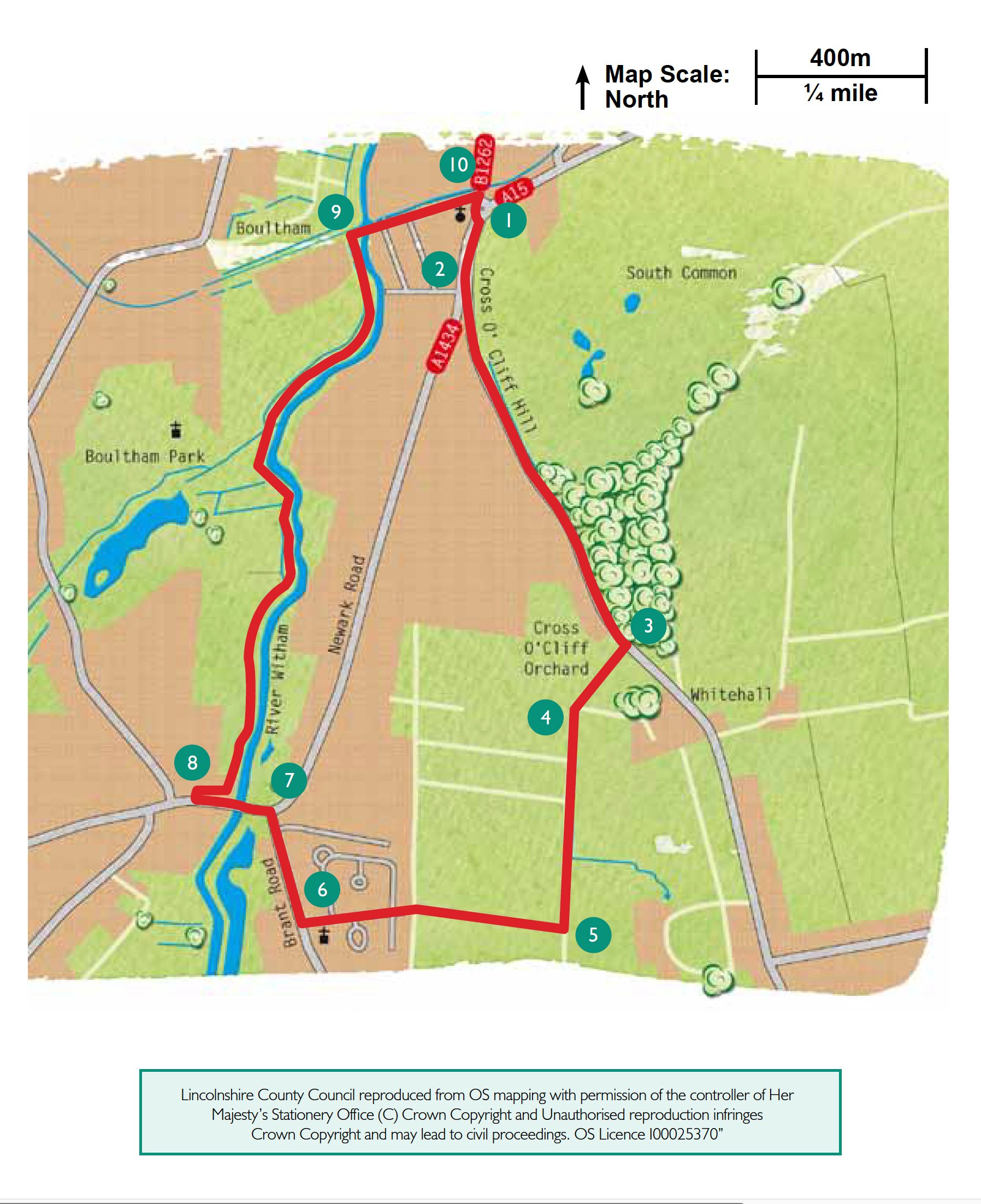
South Common one of three urban commons in Lincoln. Recent archaeological surveys have revealed a number of features on the commons including the line of the Roman road from Lincoln to London, medieval water reservoirs serving St Catherine’s Priory and training trenches for First World War soldiers. South Common covers approximately 80 hectares.

Cross o Cliff Orchard was established by William Best in the latter part of the 19th century and at that time covered approximately 2 hectares. The fruit was picked and sold commercially until the mid 1940s. The orchard contains apple, pear and plum trees, some of which are rarely seen today and have wonderful romantic names like Bolingbroke Beauty and Louise Bonne de Jersey. It is also home to a variety of wildlife and in 2005 was declared a Local Nature Reserve. Owned by the County Council, much of the practical management work is undertaken by local volunteers.

The chimney and old clay pits at the end of Orchard Walk are evidence of a brickworks established during the Lincoln building boom of the 1870s and 1880s. This works amalgamated with three others in the area to form the Lincoln Brick Company. It closed in the early 20th century because of competition from the Peterborough brick works. The old clay pits have been taken over by hawthorn, hazel, elder and dogrose and provide an area ideal for birds and wildlife.

You are now walking along the base of the Lincolnshire Edge, the limestone backbone of the county. The village of Bracebridge Heath sits on top of the edge, or cliff, here. Until 1908, when St John The Evangelist was built as a mission church, villagers had to walk down to All Saints church at Bracebridge to worship.

To the right Lincoln cathedral can be clearly seen.

All Saints is a lovely little church originally built in the 11th century and the nave you see today dates from this time. It was enlarged in the 13th century and the pillars in the south aisle are copies of those in the cathedral. At the same time the chancel was lengthened making it difficult to see the altar from the nave. To overcome this, two windows (one rectangular and one arched) were cut through the chancel wall, making a unique feature of the building. The church was restored in 1875 and the north aisle, vestry and porch added. A look at the outside of the church will show a number of carved stones set into the wall. These are fragments of coffin lids dug up and used when the south aisle was built.

  • 1Leave the Priory Centre and turn right along St Catherine’s (the main road).
  • 2After approximately 150m cross the main road, at the pedestrian crossing, and walk up Cross O’ Cliff Hill. You will walk over the bridge that crosses the old Honington railway line. Continue up Cross O’ Cliff Hill past the Priory Academy entrance. It is worth taking a short detour into Cross O’ Cliff Orchard (its entrance is marked by an information board), a Local Nature Reserve and old orchard.
  • 3Turn right along a public footpath, beside Orchard Walk. Follow the path straight ahead and through a copse.
  • 4At the end of the copse continue straight ahead along the bottom of the field for approximately 200m to the second junction of paths (ignoring the first path on the right). Turn right and immediately left along the field edge, keeping the hedge on your left.
  • 5After approximately 300m, at the second footpath sign turn right, downhill, towards the houses and church tower. Look out for the cathedral and castle on the skyline to your right. As you approach the houses you will cross the old railway line again. Follow the road straight on past a line of mature trees, including horse chestnut and lime, to a junction with Brant Road, with All Saints church on the left.
  • 6At the junction turn right and continue to the traffic lights at the junction with Newark Road.
  • 7Using the pedestrian crossings, cross Newark Road. Turn left and cross the river.
  • 8At the end of the pub car park turn right onto the public footpath and cycleway and after approximately 50m turn right to follow the path along the banks of the River Witham. As you follow the river enjoy the changing views of Lincoln cathedral and castle on the skyline.
  • 9Continue to follow the riverside path to the second bridge. Turn right to cross the river. Continue past Bargate Sluice and walk straight ahead in front of the houses to join the main Newark Road.
  • 10Turn right along Newark Road to return to the Priory Centre.

This walk uses roadside pavements, field paths and riverside path. There are no stiles and you are unlikely to encounter livestock.

more information

The Priory Centre, at the junction of St Catherine’s and Colegrave Street, LN5 8DW. Grid reference: SK 971 694.

more about the trail

Viking Way

The Viking Way is a long distance - 147 mile way-marked trail spanning from the River Humber through Lincoln to Oakham in Rutland. The route is signposted with an icon of a Viking helmet on a yellow disk.