


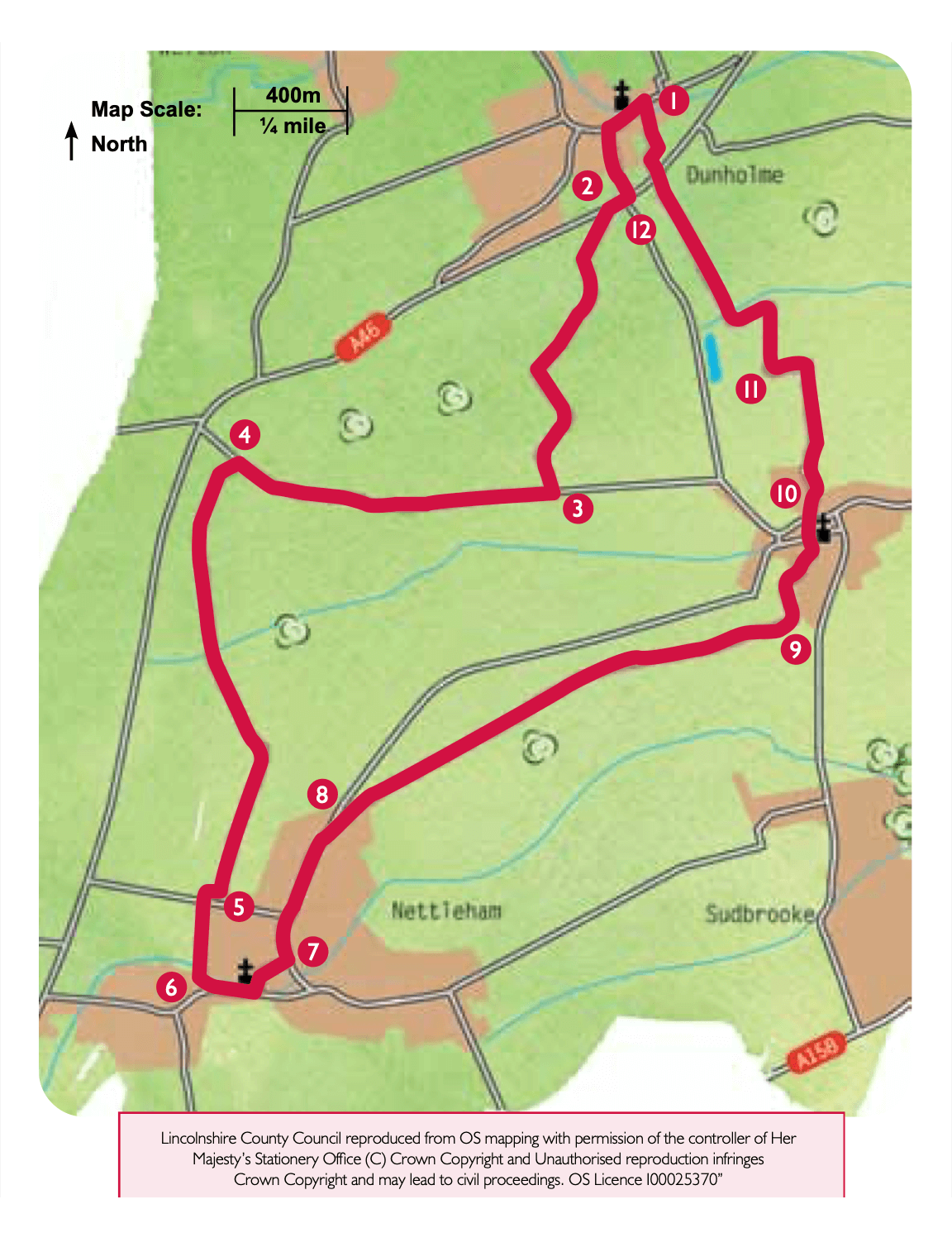
- 1From St Chad’s Church, Dunholme, cross the beck and turn right to walk in front of the Co-op to a mini roundabout. Turn left onto Scothern Lane and walk to the junction with the A46.
- 2Cross this busy road with care and join the public footpath at the corner of the field to the right of the road to Scothern. Cross two fields by bearing diagonally right and then join a track across the next field. After approximately 300m follow the footpath by bearing diagonally right across the field to a bridge. Cross the bridge and bear slightly right across the field to a road.
- 3Turn right along the road and follow it for approximately one mile to just before the junction with the A46.
- 4Turn left onto the public footpath opposite Scothern Cliff Farmhouse. Climb to the top of the ridge and follow the path across the field to the hedgerow and footpath sign. Follow the path straight on alongside the hedgerow and past the farmhouse. Continue in the same direction alongside the hedgerow and across two fields to join a track which climbs to the top of the ridge. As the track bends to the right continue straight ahead following the footpath sign by bearing left to a post in the hedgerow. Turn right and follow the hedgerow. Follow the path as it crosses the hedge and continues in the same direction across the estate road towards Nettleham village.
- 5At the main road turn right and after approximately 50m turn left onto a public bridleway. Follow the bridleway as it becomes a tarmac lane and reaches the beck.
- 6Turn left along Beckside to All Saints’ church. Turn left onto Church Street and walk through the centre of the village to the village green.
- 7Cross the green, bear left and follow the road past the library and Bill Bailey’s playing field. Walk up the hill and turn right onto Highfields.
- 8Turn left along High Leas and almost immediately right onto a public footpath to Scothern. Enter the field, turn left and walk behind the bungalows and continue straight on along the hedgerow to a bridge. Cross the next field by bearing slightly right to another bridge. Continue in the same direction and cross another five fields heading towards Scothern.
- 9At the end of the field, where a black building can be seen behind a fence, turn left and follow the field edge. At the footpath sign, turn right. After approximately 20m, turn left and follow a path along the field edge, behind the houses. Ignore a footpath on the right and at the next field corner, and junction of paths, turn right and cross the open grassed area to the far right corner. Follow the path between the hedge and a fence to a road. Walk straight on in front of St Germain’s Church to the junction with Main Street. Turn right.
- 10Almost immediately turn left into School Crescent. As School Crescent turns to the right walk straight on along the footpath next to The Cottage. Enter the farm yard and bear right, around the buildings to join a farm track. Follow this track alongside the drain turning left at a waymarker.
- 11Approximately 80m after the track bends left, turn right off the track onto a footpath, keeping the hedge on your right, and follow the field edge as it bends left to a bridge. Turn right over the bridge and walk across two fields to the A46.
- 12Cross this busy road with care and follow the footpath opposite between houses. At the estate road turn left. Turn right between the pond and houses, along a public footpath and leave the park via a narrow path which leads through a gate onto a gravel drive. Walk down the drive to Ashing Lane and turn left to return to the War Memorial and St Chad’s Church.