Walk
Loop
5.5miles
(8.85km)
2 hours
45 mins

Walking

Market Deeping Walk

Market Deeping

The Deepings lie on the southern edge of Lincolnshire and are made up of Market Deeping, West Deeping, Deeping St James and Deeping Gate. The name “Deeping” means deep or low lying fen or meadow and was given to the area by the Saxons who first occupied the area around the River Welland during the 5th century. Prior to the Saxons the Romans occupied the area and a number of Roman gravel pits were un-earthed near West Deeping during recent pipeline construction.

There is also evidence of extensive prehistoric settlements in the area between Market Deeping and West Deeping. Market Deeping, the largest of the Deepings, lies on the junction of a number of old coaching routes from London to Lincoln, London to Boston and Stamford to Boston as well as being a main crossing of the River Welland. Most of the buildings are built of stone brought down the once navigable River Welland from quarries in Northamptonshire.

Church Street is regarded as one of the prettiest in Lincolnshire dominated by the church of St Guthlac dating back to the 15th century.The church is named after the Christian who came to nearby Crowland more than twelve centuries ago to spread Christianity.

West Deeping, the smaller of the Deepings, lies on a bend of the River Welland and is one of the most picturesque villages in south Lincolnshire, worthy of a visit are the 14th century St Andrew’s Church and the nearby old water mill now converted to a private house.

Walk location: Market Deeping lies 15 km (9 miles) north of Peterborough on the A15.
Starting point: Market Square, Market Deeping. Grid Reference TF 139 099

  • ParkingParking
  • ToiletsToilets
  • Linked to Public TransportLinked to Public Transport
  • RefreshmentsRefreshments
  • Dog FriendlyDog Friendly

Molecey’s Mill was also known as the Fulling Mill and it is known that in 1563 3 corn mills called the Queens Mills stood on this site, now only the private house once owned by the Van Geest family is left standing.

The Stamford Canal ran between Market Deeping and Stamford a distance of 6¾ miles. The canal was built some time in the 1660s at a cost of £5000, after the river Welland became difficult to navigate when a number of watermills were built along its length. It was used for transporting goods by horse drawn barges until its closure in 1863 when the railway arrived in Stamford. It was the longest locked canal in the country when it was constructed and only the second post-Roman canal to have been built in Britain, the first having been built in Exeter.

Water mills could never have survived in the Fens because of their slow moving rivers and absence of fall but there were many around the edge of this flat expanse of land, particularly close to the surrounding corn growing areas. This mill was built in the 19th century although therewas a water mill on this site for many centuries, at one time West Deeping had four water mills.

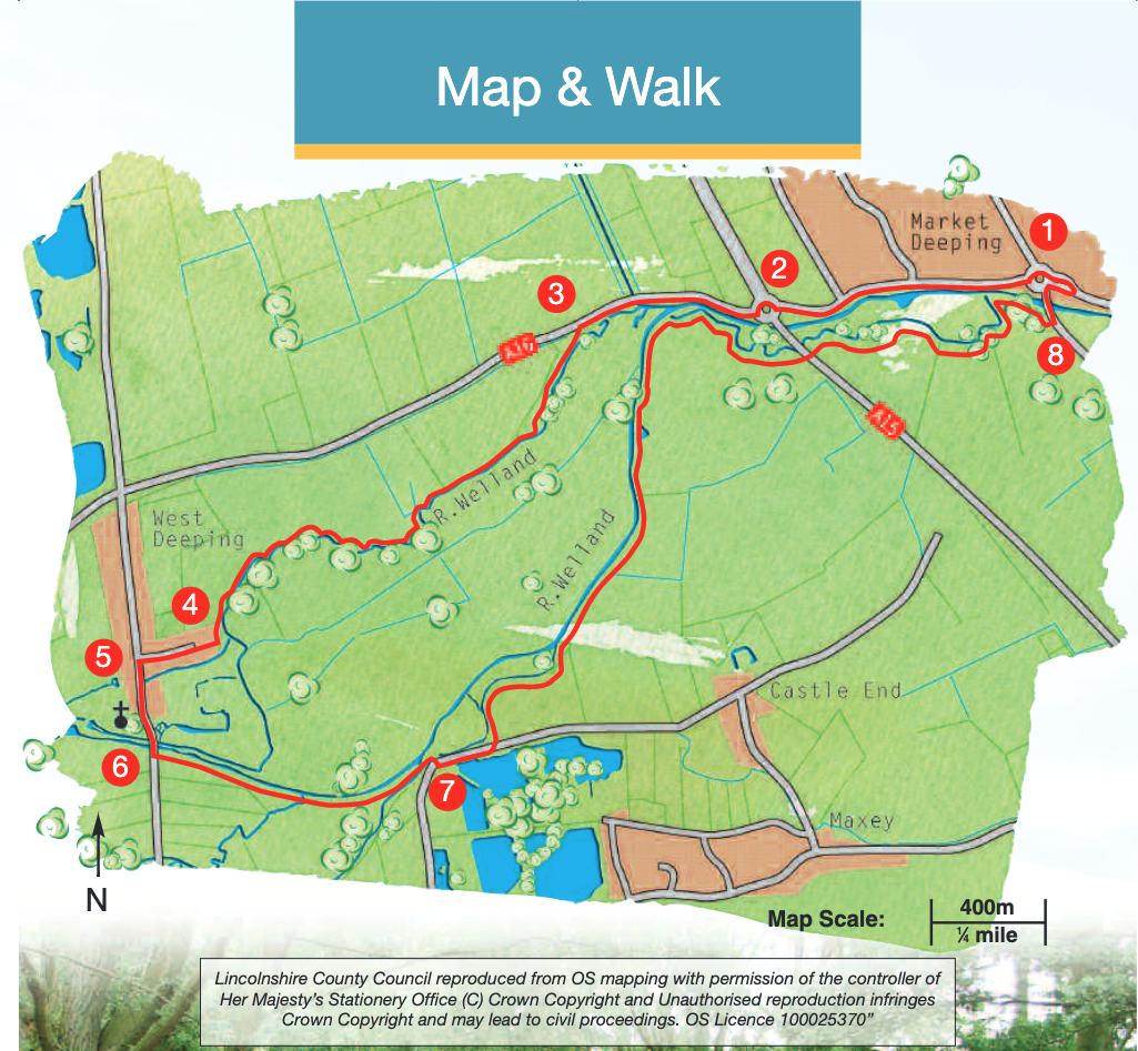
The River Welland is one of the main waterways across the Fens. It rises near Market Harborough, flows through Leicestershire, Northamptonshire and Rutland, finally into Lincolnshire at Stamford. It continues its journey through the Deepings and Spalding before ending its journey at The Wash. A total distance of 35 miles.

The present mill at Maxey dates from 1779 and is poweredfrom a breast shot wheel. The mill currently produces stone ground meal for the Grasmere farm herd of pigs.

Look out for the wildlife using the river,in particular swans, herons and kingfishers. The heron is a large majestic bird feeding on fish it catchesin the river. They nest high in trees in groups known as heronries.

The old stone bridge that carries the A15 over the River Welland was opened in 1842 and cost £8000 to build. It replaced a wooden bridge that had been at this point since the 16th century.

  • 1Leave the Market Square and walk west along Stamford Road, keeping to the right hand side roadside pavement.
  • 2At the roundabout cross the busy road with care to continue in the same direction towards Stamford. Continue over the drain known as the Greatford Cut with the old water mill on your left.
  • 3Approximately 100m past the old mill cross the road with care and follow the public footpath between the hedge and fence until you come to a tributary of the River Welland, and possibly the line of the old Stamford Canal. Follow the path along the bank for approximately 1.25 miles (two kilometres).
  • 4As you arrive at West Deeping do not cross the river but follow the path right between the house wall and fence. Follow the path between the houses to a lane. Walk down the lane to the centre of West Deeping, the Red Lion pub is immediately on your right.
  • 5Turn left down what was the old Roman road of King Street which was originally used for cattle droving and trading but is now the main street through the village. At the end of the houses take a detour right down Church Lane to admire St Andrew's Church and the old water mill.
  • 6Retrace your steps up Church Lane and turn right (from here there is a lovely view of the church across the meadows ). Cross the river over two stone bridges (next to each other) before turning left onto a public footpath into the meadows by the river. Walk the length of the field to a stile and bridge over a small stream. The path continues along the edge of the next field, through some trees and back onto the banks of the River Welland. Follow this lovely stretch of river to the sluice gate the roar of which can be heard as you approach through the trees. Continue over the sluice and follow the grassy area to the road at the corner of Maxey Mill which is the building on your right.
  • 7Turn left and after approximately 100m, turn left onto a public footpath and follow it alongside the trees until you are once again on the banks of the River, this time on the south bank and actually now in Peterborough. Continue following the river bank with views of the village of Maxey to your right. Eventually the path passes a small mast and continues under a bridge carrying the A15. Continue alongside the meandering river until you come to the old Market Deeping Bridge and road.
  • 8Turn left and walk over the bridge and return to the Market Square, Market Deeping.

The walk uses roadside pavements and field paths. The busy A15 is crossed once.

There are stiles and you may encounter livestock.

more information

Starting point: Market Square, Market Deeping, PE6 8EA

Grid Reference: TF 139 099