Walking

Bardney Short Walk

Bardney

The Lincolnshire Limewoods area, between Wragby, Bardney and Woodhall Spa, is a great place to explore with ancient woodlands, medieval abbey ruins, and a wealth of wildlife and history. This walk is one in a series where you can experience all this and more! The Lincolnshire Limewoods are the most important examples of small-leaved lime woodland remaining in Britain and as such have been designated as a National Nature Reserve (NNR). These woodlands date back to prehistoric times and are believed to be one of the few remaining examples of wildwood with continuous woodland cover for the last 8000 years. They provide a range of habitats for a variety of wildlife. Who knows what you might see! Owls, woodpeckers, bats, butterflies, moths and deer as well as colourful displays of wildflowers including wood anemones, lily of the valley, water avens, woodruff and orchids. The Witham valley has one of the largest concentrations of abbeys and priories in the country. These medieval religious houses were located close to the river following a tradition of ritual use in the prehistoric period, and because it was an important link to Lincoln and the port at Boston. In medieval times some of the woodlands would have been owned by the abbeys and played a vital role in the local economy. This walk visits two woods, Southrey and Scotgrove, and the remains of two abbeys, Tupholme and Bardney.

A circular walk through the Lincolnshire Limewoods where there are ancient woodlands, medieval abbey ruins and a wealth of wildlife and history. The walk takes in two woods, Southrey and Scotgrove, and the remains of Bardney abbey.

Starting point
War Memorial at the junction of Silver Street, Horncastle Road and Church Lane. Grid reference: TF 120 694.

  • Linked to Public TransportLinked to Public Transport
  • RefreshmentsRefreshments
  • Dog FriendlyDog Friendly

Bardney church was rebuilt after 1434 when the old parish church at the Abbey collapsed. It includes re-used architectural pieces from the Abbey. You are welcome to look around the church where you will see a large monumental slab to Abbot Richard Horncastle and a model of Bardney Abbey.

Southrey Wood is part of the Bardney Limewoods NNR and is a Site of Special Scientific Interest (SSSI). It is owned and managed by the Forestry Commission. There are a variety of tree species, look out for oak, hazel and ash, as well as lime. You may also see hazel and lime coppice stools. Coppicing is a traditional woodland management technique where stems are cut back to just above ground level and allowed to re-shoot. Coppicing is being carried out by volunteers from Butterfly Conservation to create open glades which will attract a variety of butterflies including white admiral and purple hairstreak.

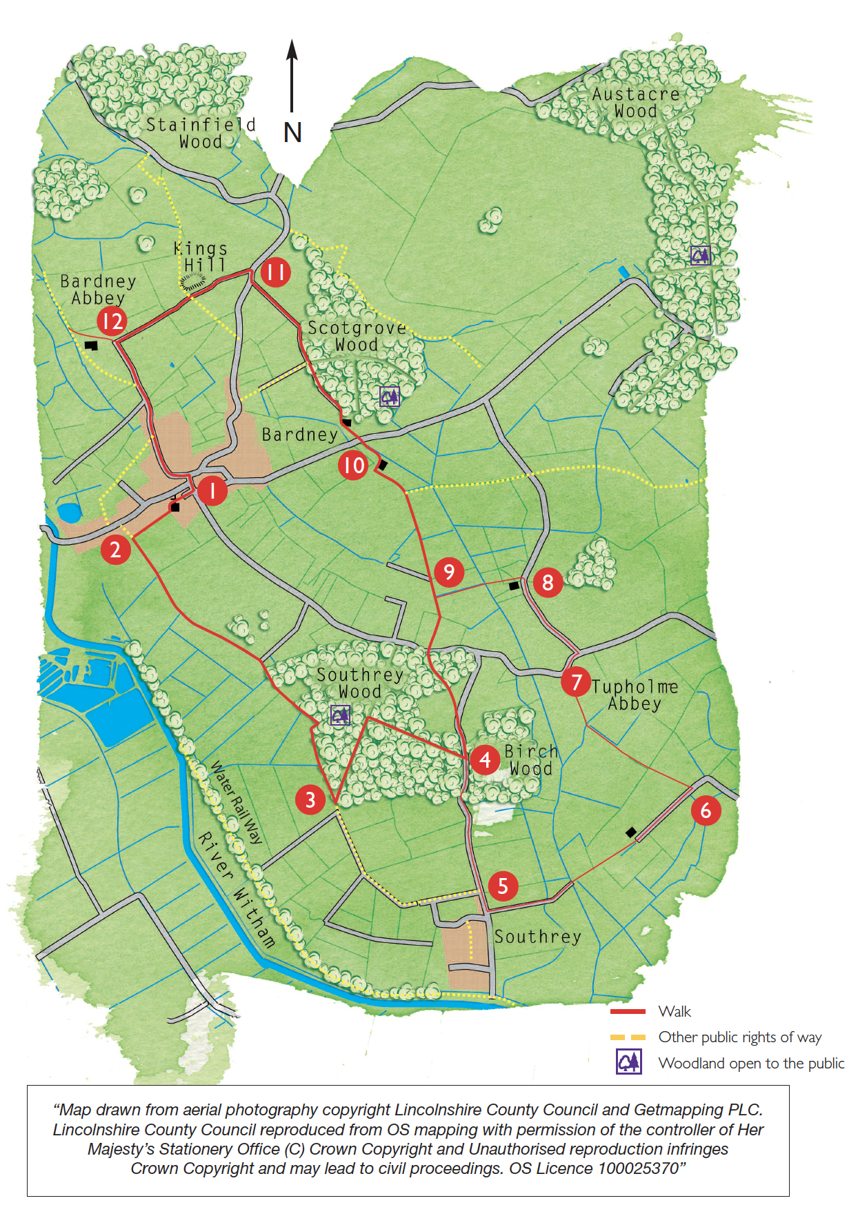
Scotgrove Wood is also a Site of Special Scientific Interest (SSSI) and part of the Bardney Limewoods NNR. It is one of several woods owned by the Forestry Commission and is open to the public. It is a working woodland so if you enter please follow any signs and requests.

There is some debate over King’s Hill as to whether it is an Anglo-Saxon burial mound associated with Oswald of Northumbria or Aethelred of Mercia, or a pillow mound (a medieval rabbit warren). It is thought more likely to be a rabbit warren. The water tower was built around 1903 and stored water from nearby boreholes for use by the village. It was used until 1938 when mains water was introduced.

The first monastery at Bardney was built in Anglo-Saxon times and from 675 housed the relics of St Oswald. It was destroyed by Vikings in 870 and the monastery re-founded in 1087 by Gilbert de Gant as part of the Benedictine Order. In 1536 with the threat of dissolution a local rebellion broke out and six monks from Bardney were hanged, drawn and quartered in Lincoln for joining the rising. The Abbey was finally dissolved in 1538.

Sir Robert Tyrwhitt acquired the land and demolished the church using the stone to build a grand house, leaving the rest to go to ruin. By 1718 all the buildings on the site had gone except for a small part of the gatehouse.
Between 1909 and 1915 the ruins were excavated and left open for public view until 1933 when due to damage by the weather, the ruins were covered over. The building outlines still remain visible today giving a sense of scale of the original structures.

  • 1Walk down Church Lane, opposite the war memorial, past St Lawrence’s church. As the road bends sharp right, turn left along the public footpath. Follow the path behind a row of houses to a junction with a bridleway.
  • 2Turn left along the bridleway and follow it straight on along the edge of Southrey Wood for approximately 1.4 miles (2.2 kilometres).
  • 3At the far corner of the wood turn left into the woodland. Turn immediately left, ignoring the permissive bridleway to the right. This is a working woodland so please respect any signs or requests. Follow this path along the edge of the wood for approximately 50m before turning right along a woodland ride. Follow the ride for approximately 500m to a clearing where the ride becomes surfaced, and turn right along a path and follow it to a road.
  • 4Turn left and follow either the path just inside the woodland and then a short stretch of road, or the road for approximately 300m. Turn left onto a public footpath and follow the old hedgerow across the field towards the wood. Enter the woodland, walk past the house and continue along the driveway to a road. Cross the road with care and follow the public bridleway opposite by walking straight on with the hedge on your left. Walk past the warehouse and follow the instructions from point 9.
  • 9Continue straight on keeping to the right-hand side of the hedge. Continue along the track to a road.
  • 10Cross the road with care and continue straight ahead along the bridleway, through the farmyard and along the track. Follow the green lane along the edge of the wood, Scotgrove Wood, and continue straight on to a road.
  • 11Turn right and walk along the road with care for approximately 70m before turning left along a bridleway. Continue past King’s Hill, the mound on the right, towards the water tower to join a lane.
  • 12To visit the Abbey site, turn right at the lane and follow it through the farmyard to the site entrance. To return to Bardney, retrace your steps through the farmyard to the lane. To return to Bardney, without visiting the Abbey site, turn left at the lane. Follow the lane into the village. At the junction with Wragby Road turn right to return to the starting point.

The walk uses village paths, field paths, woodland rides and quiet lanes, which may be muddy and uneven in places. You are likely to encounter livestock and stiles on this walk.

more information

War Memorial at the junction of Silver Street, Horncastle Road and Church Lane. Grid reference: TF 120 694.

more about the trail

Viking Way

The Viking Way is a long distance - 147 mile way-marked trail spanning from the River Humber through Lincoln to Oakham in Rutland. The route is signposted with an icon of a Viking helmet on a yellow disk.